AI-Generated Results
Finding matches…
RD Station Marketing is a marketing automation platform simply designed to help businesses grow. The software allows you to attract visitors to your website, turn them into leads and nurture them into customers, all in one place.
Not seeing what you're looking for?
Dive deeper into "StationX" on G2 AI

Online Tenant Screening: The easiest way to get great tenants and protect your investment.

RewardStation provides compensation administration and analysis tools.

NetLogo is a multi-agent programmable modeling environment designed for simulating natural and social phenomena. Developed by Uri Wilensky in 1999, it has been continuously enhanced at the Center for Connected Learning and Computer-Based Modeling. NetLogo is particularly adept at modeling complex systems that evolve over time, allowing users to instruct numerous independent "agents" operating concurrently. This capability enables exploration of the relationship between individual behaviors and the emergent patterns resulting from their interactions.
Key Features and Functionality:
- Cross-Platform Compatibility: Operates seamlessly on Mac, Windows, and Linux systems.
- Fully Programmable Language: Utilizes an extended dialect of Logo to support agent-based modeling.
- Agent-Based Modeling: Facilitates the creation and control of mobile agents (turtles) that interact over a grid of stationary agents (patches), with the ability to form networks and aggregates through link agents.
- Extensive Models Library: Offers a comprehensive collection of pre-written simulations across various disciplines, including biology, physics, chemistry, mathematics, computer science, economics, and social psychology.
- Interactive Environment: Features an interface builder with tools like buttons, sliders, switches, and monitors, along with a command center for real-time interaction.
- Visualization Tools: Provides 2D and 3D viewing options, scalable vector shapes, and dynamic plotting systems for data representation.
- Participatory Simulations with HubNet: Enables networked participatory simulations where each participant can control an agent, enhancing collaborative learning experiences.
Primary Value and User Solutions:
NetLogo serves as a versatile platform for educators, students, and researchers to construct and analyze simulations of complex systems. Its user-friendly interface and extensive documentation make it accessible for beginners, while its robust programming capabilities cater to advanced research needs. By bridging the gap between individual behaviors and collective phenomena, NetLogo aids users in understanding and predicting the dynamics of various systems, thereby facilitating informed decision-making and deeper insights into complex processes.

GeoHECRAS is an advanced hydraulic modeling software that simplifies HEC-RAS modeling as it accelerates river and floodplain analysis by reducing repetitive GIS and CAD processing. Tasks like merging DEMs, generating elevation profiles, or building HEC-RAS floodplain surfaces are completed in half the time. The software integrates LiDAR surveying data, NLCD Land Cover data, and FEMA Flood maps directly into AutoCAD, MicroStation, or ArcGIS workflows. GeoHECRAS is used for river modeling, 1D and 2D hydraulic modeling, dam breach analysis, and HEC-RAS bridge modeling, along with complex floodplain encroachment studies—all with built-in reporting and reduced external GIS dependency.

DICE Central Station is built to reduce central station activity and data entry, providing a seamless interface for operators.

Mandaala offers an all-in-one solution that transforms corporate gifting and printing into seamless engagement. With 500+ customisable products and a dedicated SaaS platform tailored to your needs, Mandaala helps streamline and automate engagement programs for employees, clients, and other stakeholders. From onboarding kits and branded stationery to marketing collateral, celebrations, and long-service awards, we simplify workflows, save time, and deliver consistent quality to help you create connections that matter.

Register visitors using kiosk or attended stations. Issue professional visitor badges and notify the host upon visitor arrival with Lobby Track.
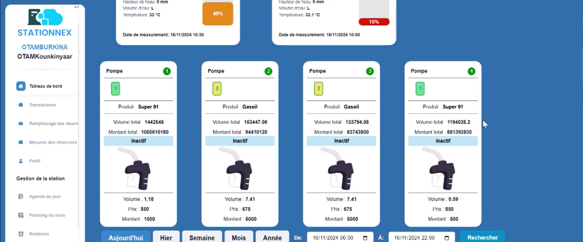
Stationnex is a comprehensive solution designed to simplify gas station management by streamlining inventory tracking, sales monitoring, and daily operations. With its user-friendly interface, you can monitor fuel levels in real-time, automate transaction tracking, and access detailed reports to boost profitability.

Trimble Field Points is designed for MEP contractors who need to create field layout points in SketchUp, Revit, or AutoCAD for direct integration with Trimble's robotic total stations.

Fleetworthy Weigh Station Bypass allows users to track their fuel, time, and money savings based on bypassing weigh stations, and their return on investment (ROI).


StationManager is a database application for tracking regulator and relief valve station information.

StationOps enables developers to manage cloud infrastructure. Provision and deploy production ready workloads on day 0 using our PaaS for your AWS account.

Leica Geosystems, a pioneer in geospatial measurement solutions, offers a comprehensive suite of products designed to enhance efficiency and precision across various construction and surveying applications. With nearly two centuries of innovation, Leica Geosystems provides tools that integrate advanced technologies such as GPS satellite navigation, laser rangefinders, and imaging laser scanners to deliver accurate and reliable data for professionals worldwide.
Key Features and Functionality:
- Total Stations: The Leica Builder series offers intuitive total stations tailored for construction sites, enabling tasks like layout, volume calculation, and as-built checks with ease.
- GNSS Solutions: The iCON gps 30 and iCON gps 70 Series provide lightweight, high-accuracy GNSS RTK rovers with advanced RTK technologies and tilt compensation, ensuring precise positioning even in challenging environments.
- Reality Capture: Devices like the BLK2GO and BLK360 imaging laser scanners capture detailed 3D representations of spaces, facilitating accurate as-built documentation and project planning.
- Machine Control Systems: The Leica iCON MC1 software platform, combined with the MCP80 control unit, offers a unified solution for various heavy construction machines, enhancing productivity through automated guidance and control.
Primary Value and User Solutions:
Leica Geosystems' products address critical challenges in the construction and surveying industries by providing:
- Enhanced Productivity: Automated and user-friendly tools reduce manual labor, allowing for faster project completion.
- Precision and Accuracy: Advanced measurement technologies ensure high-quality data, minimizing errors and rework.
- Seamless Integration: Interoperable hardware and software solutions facilitate smooth workflows across different project stages and teams.
- Scalability and Flexibility: Modular systems cater to a wide range of applications, from small-scale projects to large infrastructure developments.
By leveraging Leica Geosystems' innovative solutions, professionals can achieve greater efficiency, accuracy, and collaboration, ultimately leading to successful project outcomes.
DIgSILENT StationWare provides centralized asset management software for primary and secondary equipment.


netroStation is a visual bookmark manager to save & organize hundreds of links.

Station10 is a data consultancy firm specializing in delivering actionable insights by analyzing complex data from both online and offline sources. They collaborate closely with clients to investigate and interpret data, providing answers to strategic questions through structured 'Insight Sprints' that ensure rapid and effective results.
Key Features and Functionality:
- Customer Data Analysis: Expertise in analyzing and interpreting customer data to uncover valuable insights.
- Multichannel Journey Analysis: Comprehensive examination of customer interactions across various channels to understand behavior and optimize experiences.
- Marketing Data Interpretation: Evaluation of marketing data to assess campaign performance and inform future strategies.
- Attribution Model Development: Creation and refinement of attribution models to accurately assign value to different marketing touchpoints.
- Single Customer View Construction: Building a unified view of the customer or citizen to enhance personalization and engagement.
- Customer Segmentation and Persona Validation: Identification of distinct customer segments and validation of personas to tailor marketing efforts effectively.
- Behavioral Insights: Addressing specific questions about customer or citizen behavior to inform decision-making.
- Insight Sprints: Structured, short-term projects designed to deliver rapid, actionable insights.
Primary Value and Solutions Provided:
Station10 empowers organizations to harness their data effectively, transforming complex information into clear, actionable insights. By integrating multiple data sources and employing a tool-agnostic approach, they enable businesses to make informed decisions, optimize customer journeys, and enhance overall performance. Their rapid 'Insight Sprints' ensure that clients receive timely and relevant insights, driving strategic growth and operational efficiency.

Audio.Ad allows terrestrial radio stations and pure streaming players to monetize their digital audio streams easily, using tools to segment, serve and measure digital audio campaigns.