Top Free GIS Software

How Many GIS Software Products Does G2 Track?

Total Products under this Category: 415

Category Stats (Sep 2026)

  • Average Rating: 4.29/5 The average rating of products in this category, based on all submitted ratings
  • Top Trending Product: Smappen (+9.51%) - Among all products in this category, Smappen recorded the largest rating increase compared to last month

Last updated: September 01, 2026

How Does G2 Rank GIS Software Products?

Why You Can Trust G2's Software Rankings:

  • 30 Analysts and Data Experts
  • 8,100+ Authentic Reviews
  • 415+ Products
  • Unbiased Rankings

G2's software rankings are built on verified user reviews, rigorous moderation, and a consistent research methodology maintained by a team of analysts and data experts. Each product is measured using the same transparent criteria, with no paid placement or vendor influence. While reviews reflect real user experiences, which can be subjective, they offer valuable insight into how software performs in the hands of professionals. Together, these inputs power the G2 Score, a standardized way to compare tools within every category.

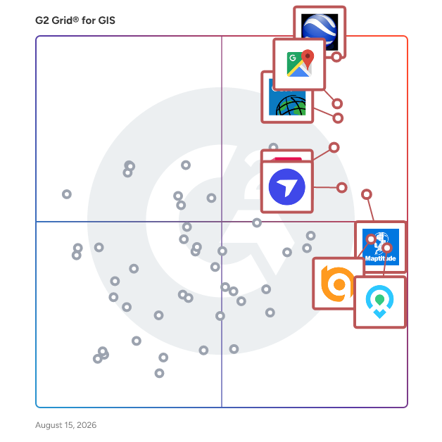
G2 Grid® for GIS Software

G2 Grid® for GIS Software plotting products by satisfaction and market presence

Highlighted products: Google Earth Pro, Google Maps Platform, Esri ArcGIS, AutoCAD, Maptitude, DroneDeploy, Mapme, and BatchGeo.

Underlying data: [Grid® JSON](https://www.g2.com/categories/gis/grids.json?focus%5B%5D=google-earth-pro&focus%5B%5D=google-maps-platform&focus%5B%5D=esri-arcgis&focus%5B%5D=autocad&focus%5B%5D=maptitude&focus%5B%5D=dronedeploy&focus%5B%5D=mapme&focus%5B%5D=batchgeo)

Esri ArcGIS

ArcGIS is a comprehensive suite of mapping and location intelligence tools and capabilities. ArcGIS can be deployed on local machines (ArcGIS Pro), on your remote or on-premises servers (ArcGIS Enterprise), or as SaaS hosted by Esri (ArcGIS Online). ArcGIS includes focused apps to deliver complete solutions for your business or organization. Along with software, Esri provides a comprehensive collection of data and content to geo-enrich your own data. ArcGIS also provides rich software development tools for you to configure and create your own mapping and location intelligence products.

Average Rating: 4.5/5.0

Total Reviews: 516

How Do G2 Users Rate Esri ArcGIS?

  • Data Capture: 9.0/10 (Category avg: 8.6/10)
  • Data Visualization: 9.1/10 (Category avg: 8.6/10)
  • Ease of Use: 7.3/10 (Category avg: 8.4/10)
  • Spatial Analysis: 9.2/10 (Category avg: 8.4/10)

Who Is the Company Behind Esri ArcGIS?

  • Seller: Esri
  • Year Founded: 1969
  • HQ Location: Redlands, CA
  • Twitter: @Esri
    188,738 Twitter followers
  • LinkedIn® Page: www.linkedin.com
    7,396 employees on LinkedIn®

Who Uses This Product?

  • Who Uses This: GIS Analyst, GIS Specialist
  • Top Industries: Government Administration, Environmental Services
  • Company Size: 39% Medium, 32% Large

What Do G2 Reviewers Say About Esri ArcGIS?

AI-generated summary from verified user reviews

Pros
  • Users find Esri ArcGIS easy to use, with a user-friendly interface that simplifies geospatial tasks and analysis.
  • Users value the high-quality 3D visualization in ArcGIS, enhancing their decision-making for professional use cases.
  • Users value the excellent data visualization capabilities of Esri ArcGIS Pro, enhancing clarity and user experience significantly.
  • Users find Esri ArcGIS to be extremely user-friendly, appreciating its ease of learning and implementation.
  • Users value the superior visualization capabilities of Esri ArcGIS, enhancing clarity and usability in geospatial analysis.
Cons
  • Users face issues with stability and integration, leading to crashes and complications when managing large datasets.
  • Users find Esri ArcGIS to be costly for small businesses, limiting access for those wanting to learn geospatial analysis.
  • Users often face integration issues with ArcGIS, making file management and sharing a frustrating experience.
  • Users find the learning curve steep, indicating a need for better training resources and tool compatibility.
  • Users find Esri ArcGIS to have a learning difficulty, suggesting additional training opportunities to improve usability.

What Are Recent G2 Reviews of Esri ArcGIS?

What Are G2 Users Discussing About Esri ArcGIS?

AutoCAD

Redefine how you create with Autodesk® AutoCAD®. Autodesk AI empowers you to reimagine your creative process in AutoCAD, delivering advanced automation and meaningful performance enhancements that help you design faster and work smarter. Intelligent features reduce repetitive tasks and surface actionable insights, so you can spend more time creating with precision and confidence. Use natural, conversational interactions to ask questions, check standards unique to your team, and quickly validate designs against established workflows. Securely managed data supports informed decision making and helps turn ideas into high quality results more efficiently. A truly collaborative design experience brings teams together through Forma Data Management. Purpose built cloud storage makes it easy to save, manage, and access project files while supporting collaborative design processes. Multiple users can add markups to a single drawing on desktop or web with Multi-user Markup, improving transparency and reducing errors. Checkout transforms collaborative drafting by allowing contributors to work on specific geometry, submit edits for review, and merge changes smoothly by eliminating manual collation and file conflicts. Your data and intellectual property remain secure and governed, giving you confidence across every stage of design. Optimize productivity with seven specialized toolsets, including Electrical, Mechanical, and Plant 3D. Automate routine tasks with AutoLISP, tailor workflows to your discipline, and extend AutoCAD through APIs and thousands of apps on the Autodesk App Store.

Average Rating: 4.4/5.0

Total Reviews: 1,850

How Do G2 Users Rate AutoCAD?

  • Data Capture: 8.6/10 (Category avg: 8.6/10)
  • Data Visualization: 8.8/10 (Category avg: 8.6/10)
  • Ease of Use: 8.3/10 (Category avg: 8.4/10)
  • Spatial Analysis: 8.5/10 (Category avg: 8.4/10)

Who Is the Company Behind AutoCAD?

  • Seller: Autodesk
  • Company Website:
  • Year Founded: 1982
  • HQ Location: San Francisco
  • Twitter: @autodesk
    273,215 Twitter followers
  • LinkedIn® Page: www.linkedin.com
    15,757 employees on LinkedIn®

Who Uses This Product?

  • Who Uses This: Architect, Designer
  • Top Industries: Architecture & Planning, Civil Engineering
  • Company Size: 45% Small, 34% Medium

What Do G2 Reviewers Say About AutoCAD?

AI-generated summary from verified user reviews

Pros
  • Users find AutoCAD to be easy to use, enhancing productivity with its intuitive tools and extensive features.
  • Users appreciate AutoCAD for its precision and professional standards, significantly enhancing their design skills and career prospects.
  • Users appreciate AutoCAD for its precision and professional standards, enhancing accuracy in engineering and architectural designs.
  • Users value the powerful 3D modeling capabilities of AutoCAD, benefiting from its precision and flexibility in design.
  • Users commend AutoCAD for its detailed engineering drawings, enhancing precision and understanding in design and drafting.
Cons
  • Users find the high subscription cost of AutoCAD to be a significant barrier, especially for students and freelancers.
  • Users struggle with the steep learning curve of AutoCAD, making it difficult for newcomers to effectively begin using the software.
  • Users find the high cost of AutoCAD to be prohibitive for freelancers and small businesses.
  • Users find the difficult learning curve of AutoCAD challenging, especially for newcomers trying to navigate its complexity.
  • Users face high hardware requirements for AutoCAD, necessitating costly, powerful computers for optimal performance.

What Are Recent G2 Reviews of AutoCAD?

What Are G2 Users Discussing About AutoCAD?

Maptitude

Maptitude is the best mapping software and GIS, on both desktop and online/SaaS/Cloud, to: • Optimize sales territories, vehicle routes, and site locations • Visualize, analyze, and present mission-critical data • Maximize profits, time, and resources Maptitude GIS and mapping software gives you the tools, maps, and data you need to analyze and understand how geography affects you and your organization. Maptitude is the most capable, and least expensive, full-featured mapping software available. With Maptitude you can create maps and map images from spreadsheets and you can see external data on the map from a variety of sources including Google Maps KML/KMZ files. Designed for data visualization and geographic analysis, Maptitude comes with a comprehensive library of maps and GIS data for your country. What Can You Do with Maptitude Mapping Software Features? • Optimize sales territories, districts, service areas, vehicle routes, and site locations • Map customer locations, visualize sales performance, and identify over- and under-served areas • Reveal hidden geographic patterns, trends, data density, and hotspots from spreadsheets and databases • Visualize and analyze population, income, and other demographic data • Plan efficient travel routes with advanced proximity, navigation, and travel time tools • Customize every aspect of your maps including symbols, themes, layers, annotations, and 3D graphics to tailor both appearance and functionality to your specific needs • Customize maps with flexible color schemes, layers, and annotations to highlight mission-critical data • Connect to corporate databases, add your own data, and answer geographic questions impacting operations • Find growth opportunities by spotting patterns you can't see in tables • Create, edit, and manage interactive maps with zoom, pan, filter, query, and layer toggle features for dynamic exploration and improved decision-making • Create, edit, and manage interactive, shareable maps for better decision-making

Average Rating: 4.7/5.0

Total Reviews: 150

How Do G2 Users Rate Maptitude?

  • Data Capture: 9.6/10 (Category avg: 8.6/10)
  • Data Visualization: 9.6/10 (Category avg: 8.6/10)
  • Ease of Use: 8.2/10 (Category avg: 8.4/10)
  • Spatial Analysis: 9.3/10 (Category avg: 8.4/10)

Who Is the Company Behind Maptitude?

  • Seller: Caliper
  • Company Website:
  • Year Founded: 1983
  • HQ Location: Newton, MA
  • Twitter: @Maptitude
    1,195 Twitter followers
  • LinkedIn® Page: www.linkedin.com
    40 employees on LinkedIn®

Who Uses This Product?

  • Who Uses This: President, Owner
  • Top Industries: Hospital & Health Care, Higher Education
  • Company Size: 54% Small, 26% Large

What Do G2 Reviewers Say About Maptitude?

AI-generated summary from verified user reviews

Pros
  • Users find Maptitude's extensive feature set invaluable for logistics and spatial analysis with user-friendly tools.
  • Users appreciate the ease of use of Maptitude, finding it straightforward for logistics and analytical tasks.
  • Users love the clear data visualization in Maptitude, enabling informed decisions and impressive narrative creation from mapping.
  • Users appreciate the data accuracy of Maptitude, which enhances their analytical capabilities and project outcomes.
  • Users appreciate the powerful GIS analysis capabilities of Maptitude, enhancing logistics and demographic project efficiency.
Cons
  • Users face limited accessibility with Maptitude, needing to deactivate licenses and lacking sufficient sharing options.
  • Users find Maptitude to be expensive due to limited sharing options and costly annual license upgrades.
  • Users find the limited sharing options in Maptitude restrictive, desiring more flexibility for collaboration without extra costs.
  • Users find the learning curve challenging, particularly for beginners, but training resources can help ease the transition.
  • Users find Maptitude a bit bewildering for newcomers, though online training helps to improve familiarity quickly.

What Are Recent G2 Reviews of Maptitude?

What Are G2 Users Discussing About Maptitude?

DroneDeploy

DroneDeploy powers field teams with robotics and AI. As the only platform that combines robotic automation, AI agents and truly unified reality capture, DroneDeploy allows critical industries to operate with speed and confidence. From construction and energy to agriculture, the world’s largest companies use DroneDeploy to simplify field operations, improve safety and make smarter decisions, faster. By combining aerial drones, 360 and fixed cameras, ground robots and proprietary AI, we’re bringing the power of automation and visual intelligence to all stakeholders, from the field to the boardroom.

Average Rating: 4.6/5.0

Total Reviews: 110

How Do G2 Users Rate DroneDeploy?

  • Ease of Use: 8.8/10 (Category avg: 8.4/10)

Who Is the Company Behind DroneDeploy?

  • Seller: DroneDeploy
  • Year Founded: 2013
  • HQ Location: San Francisco, US
  • Twitter: @DroneDeploy
    34,433 Twitter followers
  • LinkedIn® Page: www.linkedin.com
    386 employees on LinkedIn®

Who Uses This Product?

  • Who Uses This: Project Engineer
  • Top Industries: Construction, Architecture & Planning
  • Company Size: 44% Small, 39% Medium

What Do G2 Reviewers Say About DroneDeploy?

AI-generated summary from verified user reviews

Pros
  • Users appreciate the ease of use of DroneDeploy, enjoying intuitive features for planning and collaboration.
  • Users praise the user-friendly interface and exceptional customer service of DroneDeploy, enhancing their overall experience.
  • Users value the responsive and knowledgeable customer support from DroneDeploy, enhancing their overall experience and productivity.
  • Users value the intuitive flight planning and rapid map processing of DroneDeploy, significantly enhancing their workflow efficiency.
  • Users value the user-friendly flight management and mapping tools of DroneDeploy for efficient collaboration and accurate measurements.
Cons
  • Users find the service expensive, leading to difficulties in retention and understanding pricing plans.
  • Users report missing features like bulk GCP processing and account restrictions, making tasks tedious and less efficient.
  • Users experience slow processing times with DroneDeploy, impacting efficiency and usability in critical situations.
  • Users report upload issues with DroneDeploy, finding it sometimes slow and complicating their project workflows.
  • Users find 3D integration issues frustrating, with limitations on mobile and manual adjustments needed for PDFs.

What Are Recent G2 Reviews of DroneDeploy?

What Are G2 Users Discussing About DroneDeploy?

BatchGeo

BatchGeo is the easiest way to get your list of addresses on a map. Since 2006 BatchGeo has hosted millions of maps for Fortune 50 companies, non-profits, and individuals. The idea behind BatchGeo is most geographic data is stored in some sort of spreadsheet, list, or simple table (ex: Excel, CSV, Google Spreadsheets, etc.) So its optimized for those formats, making it super easy to drag in or copy/paste your tabular data into a map. Once your data is mapped the real fun begins. Your data points are spread out on an easy to navigate Google Map. Data can be color coded by groups or ranges, or even heat mapped. If routing is what you are interested in, BatchGeo can give you optimized routes for up to 23 points at a time. This ensures you don't waste time when visiting your customers. Finally, if you want to share your map it's easy to do. You can choose if your map is to be secured (password protected) or generally available to the public. BatchGeo can even be used for a store locator for your website.

Average Rating: 4.7/5.0

Total Reviews: 998

How Do G2 Users Rate BatchGeo?

  • Data Capture: 8.8/10 (Category avg: 8.6/10)
  • Data Visualization: 8.8/10 (Category avg: 8.6/10)
  • Ease of Use: 9.1/10 (Category avg: 8.4/10)
  • Spatial Analysis: 8.8/10 (Category avg: 8.4/10)

Who Is the Company Behind BatchGeo?

  • Seller: BatchGeo
  • HQ Location: VANCOUVER, Washington
  • Twitter: @batchgeo
    552 Twitter followers
  • LinkedIn® Page: www.linkedin.com
    1 employees on LinkedIn®

Who Uses This Product?

  • Who Uses This: Manager, Analyst
  • Top Industries: Real Estate, Marketing and Advertising
  • Company Size: 59% Small, 27% Medium

What Do G2 Reviewers Say About BatchGeo?

AI-generated summary from verified user reviews

Pros
  • Users find BatchGeo to be extremely easy to use, efficiently transforming data into interactive maps without technical skills.
  • Users value the easy sharing capabilities of BatchGeo, enhancing their ability to communicate geographic insights effectively.
  • Users love how BatchGeo effortlessly transforms data into interactive maps, streamlining visualization and sharing of location insights.
  • Users value the easy-to-use location services of BatchGeo, transforming data into interactive maps effortlessly.
  • Users appreciate the variety of mapping options in BatchGeo, enhancing their ability to visualize and share location data.
Cons
  • Users find the feature limitations of BatchGeo restrict advanced usage, with capped records and minimal customization options.
  • Users find the high cost of BatchGeo's Pro plan burdensome, especially for small businesses with limited budgets.
  • Users find BatchGeo to offer limited customization, especially when compared to more advanced mapping tools.
  • Users find the manual input requirement tedious as they must re-upload data after every update to BatchGeo.
  • Users find the update issues frustrating due to lack of live-sync and restrictive record limits, impacting usability.

What Are Recent G2 Reviews of BatchGeo?

What Are G2 Users Discussing About BatchGeo?

MapTiler

MapTiler is a professional-grade geospatial platform and cloud ecosystem engineered for the creation, hosting, and deployment of sophisticated digital maps. It is the preferred solution for organizations requiring granular customization, rigorous data privacy, and robust offline functionality. Leveraging high-fidelity OpenStreetMap data, MapTiler provides the foundational infrastructure necessary to power interactive mapping experiences across web, mobile, and specialized GIS environments. MapTiler makes maps easy to help everyone understand the world better. Core Products and Services: MapTiler isn't just one tool; it’s an ecosystem of products designed for different stages of the mapping process: MapTiler Cloud: A hosting platform that provides ready-to-use map styles (Streets, Satellite, Outdoor) via APIs and SDKs. MapTiler Engine: A desktop application that converts your own data - such as drone imagery, scanned paper maps, or large TIFF files—into "map tiles" that can be easily loaded on the web. MapTiler On-Prem: self-hosting solution that allows you to run maps on your own hardware. This is essential for secure environments or apps that need to work entirely offline. MapTiler SDK: A JavaScript library (based on MapLibre) that developers use to add interactive features, markers, and 3D terrain to their web applications. Why People Use It: Privacy & Security: Unlike other mapping providers, MapTiler does not collect any hidden information about people who interact with the maps. No Telemetry, saved activity, or any other data, other than voluntarily sharing their location. In addition, MapTiler supports fully on-premises hosting. This means your data (and your users' location data) never has to leave your own servers. Customization: You can edit every detail of the map’s appearance - changing colors, hiding labels, or adding your own branding - using the Map Designer tool. Scalable Financial Predictability: MapTiler offers a sustainable pricing structure that eliminates the 'success tax' common in pay-per-load models, making it the preferred choice for high-traffic applications that require cost certainty. Open Source Roots: MapTiler is a major contributor to the OpenMapTiles project, which defines how map data is structured for modern vector styling.They also helped found and continue to contribute to MapLibre, and other components of the modern OpenSource Geospatial stack.

Average Rating: 4.8/5.0

Total Reviews: 24

How Do G2 Users Rate MapTiler?

  • Data Capture: 9.2/10 (Category avg: 8.6/10)
  • Data Visualization: 9.6/10 (Category avg: 8.6/10)
  • Ease of Use: 9.6/10 (Category avg: 8.4/10)
  • Spatial Analysis: 7.5/10 (Category avg: 8.4/10)

Who Is the Company Behind MapTiler?

  • Seller: MapTiler
  • Year Founded: 2020
  • HQ Location: Zug, CH
  • Twitter: @MapTiler
    5,301 Twitter followers
  • LinkedIn® Page: www.linkedin.com
    63 employees on LinkedIn®

Who Uses This Product?

  • Company Size: 68% Small, 28% Medium

What Do G2 Reviewers Say About MapTiler?

AI-generated summary from verified user reviews

Pros
  • Users commend the API efficiency of MapTiler, enhancing their development experience with robust support and variety.
  • Users appreciate the ease of use of MapTiler, finding it responsive even on low-spec devices like Raspberry Pi.
  • Users find fast performance with MapTiler, especially on low-spec devices like Raspberry Pi-4, enhancing usability.
  • Users value the good variety of map styles in MapTiler, enhancing the overall customization experience.
Cons
  • Users face feature limitations in MapTiler, particularly regarding advanced customization and visual control options.
  • Users face limited customization options with MapTiler, particularly for advanced features like globe projection and visual control.

What Are Recent G2 Reviews of MapTiler?

Badger Maps

Your field sales tool kit to sell more– Badger Maps is the top rated mobile app for B2B reps in the field and a total territory management for your entire field team. With Badger, outside sales & field service reps get a mobile app (available on both iPhone and Android) that cuts drive time, improves data collection, and increases sales. Activities that were once a time sink like customer mapping, route planning, scheduling, data collection, and reporting are all made easy with Badger’s mobile mapping app. Paired with a suite of territory management tools that includes performance dashboards and a robust territory mapping interface, Badger Maps will enhance the workflows of everyone on your field team with features like: Route Planner & Mobile Sales Mapping - Fit 2 more meetings into each day by optimizing routes with up to 120 stops. - Visualize all your Accounts, Contacts, Leads, and Opportunities on an interactive map on your phone. - Filter and colorize accounts by custom metrics like priority status or last order date to instantly spot your best opportunities as you plan your day. - Plan and save all your routes in advance so you never fly blind on the road. Scheduling & Reminders - Sync routes to your calendar with the touch of the button. - Get alerts for follow-ups or nearby accounts that need attention. Mobile Lead Generation - Find new, qualified leads near your route– great for downtime on the road! Data Collection & A Mobile CRM Front-End - Take notes, capture photos, and keep all your customer information up to date from your phone. - Automatically sync all your data with the leading CRMs including Salesforce, HubSpot, Zoho, Microsoft Dynamics, NetSuite, Pipedrive, monday.com, Veeva, Insightly, SugarCRM, and more. - Map and access all your CRM data in the field. See the relationship between different data types so you’re never left fumbling for the information you need to serve your customers. Reporting & Mileage Tracking - Get automated reports summarizing your routes and customer activity. - Generate mileage tracking reports that make submitting your expenses easy. Territory Mapping & Management - See all your reps’ data represented in performance dashboards and customizable charts & graphs. - Use territory alignment software to automatically balance and optimize your territories. - Automate lead routing to assign new leads to the right territory instantly- no manual work needed! - Create competitions and incentivize your reps with dynamic leaderboards. - Uncover insights with territory mapping tools like heat maps, bubble maps, thematic maps & more. Get a free 14-day trial, integrated with your CRM. With optimized routes, Badger pays for itself with just the savings on gas!

Average Rating: 4.7/5.0

Total Reviews: 339

How Do G2 Users Rate Badger Maps?

  • Data Capture: 10.0/10 (Category avg: 8.6/10)
  • Data Visualization: 8.9/10 (Category avg: 8.6/10)
  • Ease of Use: 9.2/10 (Category avg: 8.4/10)
  • Spatial Analysis: 8.3/10 (Category avg: 8.4/10)

Who Is the Company Behind Badger Maps?

  • Seller: Badger Maps, Inc
  • Company Website:
  • Year Founded: 2012
  • HQ Location: San Francisco, California
  • Twitter: @BadgerMaps
    2,095 Twitter followers
  • LinkedIn® Page: www.linkedin.com
    75 employees on LinkedIn®

Who Uses This Product?

  • Who Uses This: Territory Manager, Owner
  • Top Industries: Medical Devices, Wholesale
  • Company Size: 63% Small, 24% Medium

What Do G2 Reviewers Say About Badger Maps?

AI-generated summary from verified user reviews

Pros
  • Users value the ease of use of Badger Maps, praising its smooth setup and intuitive interface for efficiency.
  • Users love the visual mapping feature of Badger Maps, which enhances organization and optimizes scheduling efficiency.
  • Users value the route optimization feature of Badger Maps, enhancing efficiency and saving valuable time.
  • Users highly value the route planning capabilities of Badger Maps, enabling efficient organization and follow-ups on visits.
  • Users appreciate the exceptional customer support of Badger Maps, enhancing their experience and product utilization.
Cons
  • Users experience routing issues with backtracking and sluggish performance, complicating navigation and efficiency in their territory.
  • Users often face mapping issues with Badger Maps, leading to imprecise navigation and address inaccuracies.
  • Users find Badger Maps to be expensive, especially for those using only a fraction of its capabilities.
  • Users feel that improvement is needed in syncing mobile and online features, and loading potential clients effectively.
  • Users find the route optimizer's lack of appointment time consideration limits efficiency and planning accuracy.

What Are Recent G2 Reviews of Badger Maps?

What Are G2 Users Discussing About Badger Maps?

Fulcrum

Fulcrum is the Field Operations Management platform field organizations use to run, record, and close out their work. Almost 3,000 companies run on Fulcrum, including electric, gas, water, and wastewater utilities and the engineering, construction, and inspection firms that serve them. Built specifically for the challenges of field teams, Fulcrum automates workflows, captures real-time location data, and integrates seamlessly with GIS and other systems to ensure a continuous, accurate flow of information before, during, and after inspections. From utilities to construction, Fulcrum supports diverse industries by offering customizable workflows that adapt to evolving field conditions. Running the whole job in one platform improves data quality at the source, builds safety into the work itself, and drives field efficiency by cutting rework and repeat trips. Non-technical users can quickly build field apps, while enterprise clients enjoy advanced scalability to manage even the most complex processes. Fulcrum’s AI-powered tools extend the platform beyond standard field operations management. Audio FastFill automatically populates forms using information captured from voice input, photos, and text, reducing manual entry in the field. Insights transforms field data into instant charts, graphs, and maps by answering plain-language questions in seconds. Teams build the workflows their jobs require and extend the platform using AI, with offline sync, geospatial data, security, and validation built in. And teams can also deploy custom AI models to support specialized workflows such as anomaly detection or vegetation management. Next, Fulcrum will introduce AI-driven photo recognition, followed by intelligent, in-the-moment guidance designed to assist field crews as they work. Organizations worldwide rely on Fulcrum to improve data accuracy, reduce operational inefficiencies, and drive digital transformation. By eliminating time-consuming manual processes, Fulcrum helps field teams work faster, smarter, and with greater confidence. Whether capturing inspection results, monitoring assets, or ensuring compliance, Fulcrum delivers the clarity and control needed to make better decisions in real time.

Average Rating: 4.6/5.0

Total Reviews: 245

How Do G2 Users Rate Fulcrum?

  • Data Capture: 8.9/10 (Category avg: 8.6/10)
  • Data Visualization: 8.0/10 (Category avg: 8.6/10)
  • Ease of Use: 9.1/10 (Category avg: 8.4/10)
  • Spatial Analysis: 10.0/10 (Category avg: 8.4/10)

Who Is the Company Behind Fulcrum?

  • Seller: Fulcrum
  • Company Website:
  • Year Founded: 2011
  • HQ Location: San Francisco, California, United States
  • Twitter: @fulcrumapp
    2,743 Twitter followers
  • LinkedIn® Page: www.linkedin.com
    162 employees on LinkedIn®

Who Uses This Product?

  • Who Uses This: Project Manager
  • Top Industries: Environmental Services, Utilities
  • Company Size: 52% Small, 29% Medium

What Do G2 Reviewers Say About Fulcrum?

AI-generated summary from verified user reviews

Pros
  • Users find Fulcrum very easy to navigate, appreciating its efficiency and ability to enhance productivity effortlessly.
  • Users find Fulcrum user-friendly, allowing easy app customization and a seamless experience for employees in the field.
  • Users appreciate the easy setup of Fulcrum, which enhances their workflow and data management during inspections.
  • Users value the high customization options of Fulcrum, tailoring apps effortlessly to meet their business needs.
  • Users value the excellent customer support of Fulcrum, ensuring quick assistance and smooth operations for their projects.
Cons
  • Users face challenges with editing after synchronization, limiting their ability to correct mistakes in Fulcrum.
  • Users find the limited features of Fulcrum hinder their ability to create complex forms and aggregated reports.
  • Users find Fulcrum's interface not user-friendly, facing challenges with navigation and report customization without coding skills.
  • Users express frustration over limited functionality and challenges in creating customized complex forms for client data aggregation.
  • Users find the form complexity in Fulcrum challenging, especially when customizing reports without coding knowledge.

What Are Recent G2 Reviews of Fulcrum?

What Are G2 Users Discussing About Fulcrum?

Smarty

Smarty offers global address verification, address validation, and geocoding via API, bulk upload, and a collection of 3rd party integrations that transform how organizations handle address data. With real-time address autocomplete, correction, standardization, and validation, it guarantees the accuracy and reliability of addresses. Smarty's US rooftop geocoding, reverse geocoding, and property data APIs help you enrich and hone your address data. These powerful APIs have far-reaching benefits, from improving the efficiency of your marketing campaigns to enhancing data analysis and operational processes.

Average Rating: 4.6/5.0

Total Reviews: 313

How Do G2 Users Rate Smarty?

  • Data Capture: 9.5/10 (Category avg: 8.6/10)
  • Data Visualization: 9.0/10 (Category avg: 8.6/10)
  • Ease of Use: 9.3/10 (Category avg: 8.4/10)
  • Spatial Analysis: 9.2/10 (Category avg: 8.4/10)

Who Is the Company Behind Smarty?

  • Seller: Smarty
  • Company Website:
  • Year Founded: 2011
  • HQ Location: Provo, Utah
  • Twitter: @smartycompany
    1,251 Twitter followers
  • LinkedIn® Page: www.linkedin.com
    153 employees on LinkedIn®

Who Uses This Product?

  • Who Uses This: CTO, CEO
  • Top Industries: Computer Software, Financial Services
  • Company Size: 51% Small, 38% Medium

What Do G2 Reviewers Say About Smarty?

AI-generated summary from verified user reviews

Pros
  • Users appreciate the ease of use of Smarty, enhancing efficiency and saving time in address verification processes.
  • Users appreciate the effective address validation by Smarty, significantly reducing undelivered mail and saving costs.
  • Users praise the easy integration of Smarty, enhancing workflows and streamlining processes effortlessly.
  • Users value the data accuracy of Smarty, appreciating its precise address suggestions and error correction capabilities.
Cons
  • Users face integration issues due to the lack of a testing environment and limited support responsiveness.
  • Users express frustration with address validation issues, citing formatting errors that occasionally disrupt functionality.
  • Users find the API issues confusing, impacting the ease of obtaining desired results and navigating the service.

What Are Recent G2 Reviews of Smarty?

Mergin Maps

Mergin Maps is a field data collection tool built on the free and open-source QGIS which allows you to collect, store and synchronise your data with your team. It removes the pain of writing down paper notes, georeferencing photos and transcribing GPS coordinates. With Mergin Maps, you can get your QGIS projects into the mobile app, collect data and synchronise it back on the server. Setting up your project with Mergin Maps only takes a few minutes. First, create your survey project in QGIS, then connect it to Mergin Maps with a plugin and synchronise it with the mobile app to start collecting in the field. The data you capture in the field survey is shown on a map and can be exported to a wide variety of formats including CSV, Microsoft Excel, ESRI Shapefile, Mapinfo, GeoPackage, PostGIS, AutoCAD DXF, and KML. Mergin Maps allows you to do live position tracking, fill out survey forms and capture and edit points, lines or polygons. You can also connect external GPS/GNSS devices via Bluetooth for high-precision surveying. Map layers look the same as in QGIS desktop so you can set your layer symbology how you want it on the desktop and it will appear that way on your mobile device. Mergin Maps supports offline field data capture for situations where a data connection is unavailable. It can be configured to use either offline or web-based background maps and contextual layers. Perks of the Mergin Maps sync system: - No need for cables to get your data on/off your device - Share projects with others for collaborative working, even offline - Updates from different surveyors are intelligently merged - Push data back from the field in real time - Version history and cloud-based backup - Fine-grained access control - Record metadata such as EXIF, GPS and external GNSS device information - Sync with your PostGIS datasets and external media storage such as S3 and MinIO Supported field types for forms are: - Text (single or multi-line) - Numeric (plain, with +/- buttons or with slider) - Date / time (with calendar picker) - Photo - Checkbox (yes/no values) - Drop-down with predefined values - Drop-down with values from another table

Average Rating: 4.7/5.0

Total Reviews: 34

How Do G2 Users Rate Mergin Maps?

  • Data Capture: 9.2/10 (Category avg: 8.6/10)
  • Data Visualization: 7.6/10 (Category avg: 8.6/10)
  • Ease of Use: 8.8/10 (Category avg: 8.4/10)
  • Spatial Analysis: 7.7/10 (Category avg: 8.4/10)

Who Is the Company Behind Mergin Maps?

Who Uses This Product?

  • Top Industries: Environmental Services
  • Company Size: 71% Small, 29% Medium

What Do G2 Reviewers Say About Mergin Maps?

AI-generated summary from verified user reviews

Pros
  • Users commend the ease of use of Mergin Maps, appreciating its intuitive interface and minimal training requirements.
  • Users value the user-friendly interface of Mergin Maps, making data collection and analysis straightforward and efficient.
  • Users value the easy integration with QGIS, enhancing their field data collection experience significantly.
  • Users enjoy the user-friendly mapping features of Mergin Maps, facilitating efficient data collection and visualization.
  • Users commend the responsive and helpful customer support from Mergin Maps, enhancing their overall experience.
Cons
  • Users face integration issues that require additional training and adjustments for compatibility with existing systems.
  • Users find the learning curve steep due to limited familiarity in the industry, necessitating additional training.
  • Users find the DB sync setup overly complex, particularly due to the requirement for an API to access cloud data.
  • Users face slow support response times, particularly concerning urgent issues like data access and subscription complications.
  • Users face storage limitations on the free plan, which can hinder the use of larger datasets in Mergin Maps.

What Are Recent G2 Reviews of Mergin Maps?

MapBusinessOnline

MapBusinessOnline is a mapping software for business intelligence. Thousands of businesses choose MapBusinessOnline to generate insightful maps, manage territories, perform market analysis, optimize logistics, and more. Designed for general business users, it addresses all business mapping needs in one easy-to-use application. MapBusinessOnline contains commercial-grade data, including ZIP codes, street-level maps, demographic data, and business listings. Capable of handling small and large datasets, MapBusinessOnline is a proven solution for increasing business efficiency. Choose from three location-based mapping product options: MapBusinessOnline Pro for advanced territory management, driving time, and distances queries, and for maximum demographic analysis capabilities. MapBusinessOnline Standard for affordable territory management and excellent map visualizations. MapBusinessOnline Starter for beginners and basic map visualizations. All advanced products include the features of lower-priced options.

Average Rating: 4.5/5.0

Total Reviews: 52

How Do G2 Users Rate MapBusinessOnline?

  • Data Capture: 8.1/10 (Category avg: 8.6/10)
  • Data Visualization: 8.1/10 (Category avg: 8.6/10)
  • Ease of Use: 8.4/10 (Category avg: 8.4/10)
  • Spatial Analysis: 8.5/10 (Category avg: 8.4/10)

Who Is the Company Behind MapBusinessOnline?

  • Seller: SpatialTEQ Inc.
  • Year Founded: 1996
  • HQ Location: Cornish, ME
  • Twitter: @MapBusinessLive
    508 Twitter followers
  • LinkedIn® Page: www.linkedin.com
    2 employees on LinkedIn®

Who Uses This Product?

  • Top Industries: Manufacturing
  • Company Size: 46% Medium, 40% Small

What Do G2 Reviewers Say About MapBusinessOnline?

AI-generated summary from verified user reviews

Pros
  • Users praise the ease of use of MapBusinessOnline, highlighting its simple setup and intuitive functionality.
  • Users value the mapping features of MapBusinessOnline for insightful data visualization and regional management.
  • Users value the easy integrations of MapBusinessOnline, enabling seamless setup and efficient updates for their teams.
  • Users value the comprehensive features of MapBusinessOnline, enhancing their ability to manage and visualize company territories effectively.
  • Users value the comprehensive features of MapBusinessOnline, enhancing their ability to visualize data and make informed decisions.
Cons
  • Users face a steep learning curve with MapBusinessOnline, needing time and resources to fully understand its features.
  • Users note a learning difficulty with MapBusinessOnline, often requiring extensive time and resources to master its features.
  • Users face big data issues with limits that can max out quickly, requiring regular maintenance and caution.
  • Users find data issues problematic, noting limits can max out quickly without regular maintenance, causing inconvenience.
  • Users find data management time-consuming, often needing to create and format multiple data files for each map.

What Are Recent G2 Reviews of MapBusinessOnline?

What Are G2 Users Discussing About MapBusinessOnline?

Mapbox

Mapbox is the live location platform preferred by over 4 million developers. Mapbox provides precise location data and flexible developer tools that equip any business to add geospatial features to their applications and enhance operations with location intelligence. Customers span automotive, logistics, business intelligence, retail, travel, data visualization, consumer apps, weather, IoT, geospatial analysis, and beyond. With the leading map rendering technology for web and mobile, Mapbox is known for providing highly performant, customizable, reliable, and scalable location services trusted by developers, companies, and business leaders. Mapbox services include global map data, real-time traffic, geocoding and address search, and routing and directions for navigation. Build with Mapbox via APIs, code libraries, SDKs, and comprehensive developer documentation. Designed for businesses of all sizes, Mapbox is free to start building with and pricing is based on monthly usage, no upfront licenses or contracts required. Mapbox is a global team of 700+ with offices in Washington D.C., Helsinki, and Tokyo. Mapbox was founded in 2010. Today, Mapbox powers the location intelligence of platforms, apps, and brands around the world.

Average Rating: 4.3/5.0

Total Reviews: 41

How Do G2 Users Rate Mapbox?

  • Data Capture: 9.0/10 (Category avg: 8.6/10)
  • Data Visualization: 9.2/10 (Category avg: 8.6/10)
  • Ease of Use: 8.4/10 (Category avg: 8.4/10)
  • Spatial Analysis: 8.3/10 (Category avg: 8.4/10)

Who Is the Company Behind Mapbox?

  • Seller: Mapbox
  • Year Founded: 2011
  • HQ Location: Washington D.C.
  • Twitter: @Mapbox
    76,538 Twitter followers
  • LinkedIn® Page: www.linkedin.com
    956 employees on LinkedIn®

Who Uses This Product?

  • Company Size: 66% Small, 20% Medium

What Are Recent G2 Reviews of Mapbox?

CARTO

CARTO is the leading Agentic GIS platform. Unlike other GIS systems, CARTO removes data fragmentation and technical bottlenecks by letting you build AI Agents, geospatial workflows, and interactive maps directly inside your cloud data warehouse or lakehouse. With CARTO for Agents, those same capabilities extend into the agentic platforms your teams already use, so spatial analysis and reports run at scale without manual effort. Every team gets Location Intelligence that lives inside your existing, governed cloud infrastructure, and powers use cases like network planning, risk assessments, and identifying growth opportunities. 100% CLOUD-NATIVE: YOUR DATA NEVER MOVES CARTO runs natively on top of the cloud data warehouse you already use, including Google BigQuery, Snowflake, Amazon Redshift, Databricks, Oracle, and PostgreSQL. Every action, from querying a table to running an AI Agent, happens inside your warehouse. There is no data replication, no separate spatial database to maintain, and no ETL to move geospatial data in and out. Many platforms claim to be cloud-native but still ask you to copy or process data externally. CARTO operates where your data already lives. AGENTIC GIS: TWO WAYS TO PUT AI AGENTS TO WORK CARTO AI Agents bring conversational spatial analysis to business users inside CARTO Builder maps and deck.gl applications. Users ask questions in plain language and get back answers, maps, and analysis, without waiting on a specialist. CARTO for Agents brings the platform into the agentic tools your teams already work in, including Claude, ChatGPT, Gemini, Microsoft Copilot, and Snowflake Cortex, plus coding agents such as Claude Code, Codex, Cursor, and Gemini CLI. It is built on the open Agent Skills and Model Context Protocol (MCP) standards, and delivered through the CARTO MCP Server, the CARTO CLI, and CARTO Agent Skills. There is no lock-in to a single agent stack. The platform is model-agnostic. You use your own approved LLMs and endpoints, so your data never has to move into a vendor's AI environment. Because agents call versioned CARTO Workflows rather than generating one-off SQL, results are deterministic and any analyst can open the workflow and see exactly how an answer was produced. WHAT YOU CAN BUILD CARTO Builder: interactive maps, dashboards, and map-based applications with no code required, including maps with AI Agents built in. CARTO Workflows: hundreds of low-code, drag-and-drop components for spatial analysis and data preparation. Workflows can be scheduled, versioned, and published as MCP Tools for AI Agents to call. Analytics Toolbox: advanced spatial SQL functions installed and run natively in your data warehouse, covering Spatial Indexes such as H3 and Quadbin, clustering, statistics, routing, and spatial data science. Data Observatory: public and premium spatial datasets, including demographics, mobility, points of interest, and environmental data, delivered straight into your warehouse. CARTO for Developers: deck.gl based libraries, APIs, and templates for building custom geospatial applications at any data volume. Integrations: QGIS plugin, embedding in BI tools, and connections across your wider cloud and AI stack.

Average Rating: 4.5/5.0

Total Reviews: 64

How Do G2 Users Rate CARTO?

  • Data Capture: 8.3/10 (Category avg: 8.6/10)
  • Data Visualization: 8.3/10 (Category avg: 8.6/10)
  • Ease of Use: 8.7/10 (Category avg: 8.4/10)
  • Spatial Analysis: 8.3/10 (Category avg: 8.4/10)

Who Is the Company Behind CARTO?

  • Seller: CartoDB
  • Year Founded: 2012
  • HQ Location: New York, NY
  • Twitter: @CARTO
    31,099 Twitter followers
  • LinkedIn® Page: www.linkedin.com
    343 employees on LinkedIn®

Who Uses This Product?

  • Top Industries: Telecommunications, Information Technology and Services
  • Company Size: 47% Small, 31% Large

What Do G2 Reviewers Say About CARTO?

AI-generated summary from verified user reviews

Pros
  • Users commend the ease of use of CARTO, making map creation and data visualization intuitive and efficient.
  • Users love the easy and intuitive map creation with CARTO, enhancing their ability to visualize complex data.
  • Users highlight the user-friendly 3D visualization capabilities of CARTO, making complex data easy to interpret and share.
  • Users value the powerful and user-friendly data visualization tools of CARTO, enhancing their ability to share insights effortlessly.
  • Users value the powerful and intuitive visualization capabilities of CARTO, enhancing their data-driven decision-making processes.
Cons
  • Users face challenges with big data issues, as advanced features require SQL knowledge and performance may lag with large datasets.
  • Users find the customization difficult, often needing SQL skills or workarounds for advanced features.
  • Users find the limited customization options of CARTO frustrating, often needing SQL knowledge for advanced features.
  • Users experience slow loading times when CARTO handles large datasets, impacting their overall efficiency.
  • Users report that CARTO can be slow when handling large datasets, impacting overall user experience and efficiency.

What Are Recent G2 Reviews of CARTO?

What Are G2 Users Discussing About CARTO?

Scribble Maps

Trusted for over 15 years by hobbyists and professionals, Scribble Maps offers an intuitive online platform for web mapping and data visualization. Users can annotate maps, plot territories, filter and analyze data, optimize routes, and more—all with a low learning curve that makes map creation accessible to every level of an organization. Founded in 2009, Scribble Maps has been continuously refined through direct user feedback. Our team portal lets teams collaborate and work together on maps and with a host of exporting options, Scribble Maps can integrate with existing work flows to bring geospatial capability to your entire organization.

Average Rating: 4.6/5.0

Total Reviews: 195

How Do G2 Users Rate Scribble Maps?

  • Data Capture: 9.2/10 (Category avg: 8.6/10)
  • Data Visualization: 9.5/10 (Category avg: 8.6/10)
  • Ease of Use: 9.0/10 (Category avg: 8.4/10)
  • Spatial Analysis: 8.9/10 (Category avg: 8.4/10)

Who Is the Company Behind Scribble Maps?

  • Seller: Scribble Maps
  • Company Website:
  • Year Founded: 2009
  • HQ Location: Walnut, California
  • Twitter: @scribblemaps
    4,106 Twitter followers
  • LinkedIn® Page: www.linkedin.com
    4 employees on LinkedIn®

Who Uses This Product?

  • Top Industries: Construction, Real Estate
  • Company Size: 70% Small, 24% Medium

What Do G2 Reviewers Say About Scribble Maps?

AI-generated summary from verified user reviews

Pros
  • Users value the ease of use of Scribble Maps, enabling quick map creation without prior training or expertise.
  • Users appreciate the intuitive mapping features of Scribble Maps, enabling easy customization and effective communication for projects.
  • Users appreciate the intuitive interface of Scribble Maps, enabling effortless map creation and sharing without prior expertise.
  • Users appreciate the intuitive interface of Scribble Maps, enabling effortless map personalization and easy sharing of information.
  • Users appreciate the intuitive design quality of Scribble Maps, enabling quick and easy customization for diverse mapping needs.
Cons
  • Users find the limited customization options of Scribble Maps can lead to cluttered interfaces and inefficiency in managing projects.
  • Users experience lag and cluttered maps when adding many elements, making navigation and organization challenging.
  • Users find that app bugs lead to a disorganized interface in Scribble Maps, making navigation difficult with too many markers.
  • Users find customization difficult, especially when handling large projects that require precise tools and easier CAD integration.
  • Users experience feature limitations with Scribble Maps, noting lag and a desire for more creative options.

What Are Recent G2 Reviews of Scribble Maps?

What Are G2 Users Discussing About Scribble Maps?

MapInfo Pro

Location-based decisions: Explore, model and act with confidence. Harness the power of sophisticated mapping and geographical analysis software to make intelligent and productive business decisions. Location adds complexity to many decisions, and mistakes are too expensive for a “trial and error” approach. With MapInfo Pro, customers can easily identify – and make better decisions on – people, places, and patterns of interest. More and more people need to explore, model and act with confidence on… - Site selection - Asset management - Demand management - Risk management/ service resource allocation MapInfo Pro delivers: 1) An all-in-one solution A full-featured desktop solution to prepare data for web mapping applications and create presentation quality maps in a familiar environment that combines data analysis, visual insights, and map publishing. - Data analysis - Visual insights - Map publishing 2) MapInfo Marketplace Enhance your location analytics with the MapInfo Marketplace. Bring analytics to life and solve your specific business needs with customized apps that are released and updated continuously. 3) Team MapInfo Pro supports the larger team of business experts, database experts, and developers who collaborate to deliver “self-serve” decision tools across the entire organization allowing location analysts to focus on special projects and creating templates for others to use. 4) Community The MapInfo community is your professional peer group of location analysts who can provide ideas, tips and tricks, and help guide the future development of MapInfo Pro Make the move to MapInfo Pro v2021 and join the MapInfo Pro community. Together, we’ll take a new, exciting journey as we collaborate to improve the future of mapping analytics.

Average Rating: 4.1/5.0

Total Reviews: 107

How Do G2 Users Rate MapInfo Pro?

  • Data Capture: 8.7/10 (Category avg: 8.6/10)
  • Data Visualization: 8.3/10 (Category avg: 8.6/10)
  • Ease of Use: 7.9/10 (Category avg: 8.4/10)
  • Spatial Analysis: 8.2/10 (Category avg: 8.4/10)

Who Is the Company Behind MapInfo Pro?

  • Seller: Precisely
  • HQ Location: Burlington, Massachusetts
  • Twitter: @PreciselyData
    3,963 Twitter followers
  • LinkedIn® Page: www.linkedin.com
    3,046 employees on LinkedIn®

Who Uses This Product?

  • Top Industries: Civil Engineering, Telecommunications
  • Company Size: 46% Large, 28% Medium

What Are Recent G2 Reviews of MapInfo Pro?

What Are G2 Users Discussing About MapInfo Pro?