Best GIS Software - Page 4

How Many GIS Software Products Does G2 Track?

Total Products under this Category: 353

Category Stats (Aug 2026)

  • Average Rating: 4.28/5 The average rating of products in this category, based on all submitted ratings
  • Top Trending Product: Octave Alto SDKs (Luciad) (+3.41%) - Among all products in this category, Octave Alto SDKs (Luciad) recorded the largest rating increase compared to last month

Last updated: August 06, 2026

How Does G2 Rank GIS Software Products?

Why You Can Trust G2's Software Rankings:

  • 30 Analysts and Data Experts
  • 8,000+ Authentic Reviews
  • 353+ Products
  • Unbiased Rankings

G2's software rankings are built on verified user reviews, rigorous moderation, and a consistent research methodology maintained by a team of analysts and data experts. Each product is measured using the same transparent criteria, with no paid placement or vendor influence. While reviews reflect real user experiences, which can be subjective, they offer valuable insight into how software performs in the hands of professionals. Together, these inputs power the G2 Score, a standardized way to compare tools within every category.

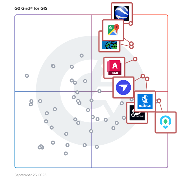
G2 Grid® for GIS Software

G2 Grid® for GIS Software plotting products by satisfaction and market presence

Highlighted products: Google Earth Pro, Google Maps Platform, Esri ArcGIS, AutoCAD, Maptitude, DroneDeploy, Mapme, and BatchGeo.

Underlying data: [Grid® JSON](https://www.g2.com/categories/gis/grids.json?focus%5B%5D=google-earth-pro&focus%5B%5D=google-maps-platform&focus%5B%5D=esri-arcgis&focus%5B%5D=autocad&focus%5B%5D=maptitude&focus%5B%5D=dronedeploy&focus%5B%5D=mapme&focus%5B%5D=batchgeo)

Sponsored

Smarty

Smarty offers global address verification, address validation, and geocoding via API, bulk upload, and a collection of 3rd party integrations that transform how organizations handle address data. With real-time address autocomplete, correction, standardization, and validation, it guarantees the accuracy and reliability of addresses. Smarty's US rooftop geocoding, reverse geocoding, and property data APIs help you enrich and hone your address data. These powerful APIs have far-reaching benefits, from improving the efficiency of your marketing campaigns to enhancing data analysis and operational processes.

Visit website

ZeeMaps

ZeeMaps is a company that allows a consumer to make and publish maps that are interactive.

Average Rating: 4.4/5.0

Total Reviews: 34

How Do G2 Users Rate ZeeMaps?

  • Data Capture: 7.8/10 (Category avg: 8.6/10)
  • Data Visualization: 8.9/10 (Category avg: 8.6/10)
  • Ease of Use: 8.3/10 (Category avg: 8.4/10)
  • Spatial Analysis: 7.6/10 (Category avg: 8.4/10)

Who Is the Company Behind ZeeMaps?

  • Seller: ZeeMaps
  • HQ Location: Cupertino, California
  • Twitter: @zeemaps
    1,001 Twitter followers
  • LinkedIn® Page: www.linkedin.com
    2 employees on LinkedIn®

Who Uses This Product?

  • Top Industries: Information Technology and Services, Computer Software
  • Company Size: 59% Medium, 24% Small

What Are Recent G2 Reviews of ZeeMaps?

What Are G2 Users Discussing About ZeeMaps?

Global Mapper

Global Mapper’s intuitive user interface and logical layout help smooth the learning curve and ensure that users will be up-and-running in no time. To add to the usability, nearly 400 file formats are supported for import and export. This all-in-one software allows users to complete their entire workflow within the same software with tools such as contour creation, watershed analysis, and multiband raster calculations. Top Tools Include: • Access to online data sources for streaming imagery, terrain and vector data • Immersive 3D visualization • Workflow automation with scripting • Site plan with cut and fill analysis • Generate terrain models (REM, DSM, and DEM) • Terrain analysis including contour generation and path profile Global Mapper Pro® expands upon the extensive functionality of the standard version of the application. Users can take advantage of the comprehensive collection of tools for advanced 3D analysis, lidar and photogrammetric point cloud processing, drone-collected image analysis, Python scripting methods, machine-learning integration and much more. Award-winning machine learning has been integrated with the beloved automatic point cloud classification. In addition to the built-in models for auto-classifying ground, building, vegetation and powerline points, custom classes can be created by users. Top Tools Include: • Pixels to Points: Photogrammetric toolset • Filtering and editing of lidar point clouds • Automatic classification of ground, vegetation, buildings, power lines, and poles • Terrain Painting • Solar analysis from loaded terrain and 3D features • Global Mapper Insight and Learning Engine: Deep-learning powered object detection and land cover classification Developed for both GIS professionals and map enthusiasts, Global Mapper® has all the functionality you need in a GIS software. Take GIS into the field with Global Mapper Mobile. This iOS and Android application makes viewing and collecting data on-the-go easy. • Display vector, raster, and elevation layers • Drawing, tracing and form-based collection • Connection to GNSS and GPS receivers • Terrain Analysis: contour creation, volume calculation and viewshed

Average Rating: 4.3/5.0

Total Reviews: 30

How Do G2 Users Rate Global Mapper?

  • Data Capture: 8.7/10 (Category avg: 8.6/10)
  • Data Visualization: 8.7/10 (Category avg: 8.6/10)
  • Ease of Use: 7.8/10 (Category avg: 8.4/10)
  • Spatial Analysis: 8.0/10 (Category avg: 8.4/10)

Who Is the Company Behind Global Mapper?

  • Seller: Blue Marble
  • Year Founded: 1993
  • HQ Location: Hallowell, ME
  • Twitter: @BlueMarbleGeo
    1,854 Twitter followers
  • LinkedIn® Page: www.linkedin.com
    56 employees on LinkedIn®

Who Uses This Product?

  • Top Industries: Oil & Energy, Civil Engineering
  • Company Size: 40% Medium, 33% Small

What Are Recent G2 Reviews of Global Mapper?

What Are G2 Users Discussing About Global Mapper?

eSpatial

eSpatial is cloud-based mapping software that is engineered for the enterprise and designed for the user. We believe mapping should be fast, easy and powerful. With our mapping software, you can easily upload, visualize, and analyze multiple layers of data. It’s rapid visual insight that takes the guesswork out of decision making. We are mapping experts and have been delivering geographic solutions for over twenty years. Trusted by our customers and partners from Fortune 500 companies to non-profit organizations that span nearly every industry, we are committed to helping our users reach their mapping goals. eSpatial has a comprehensive set of features that enables you to visualize, analyze and share your business data currently stored in spreadsheets, CRM or ERP systems.

Average Rating: 4.3/5.0

Total Reviews: 38

How Do G2 Users Rate eSpatial?

  • Data Capture: 8.3/10 (Category avg: 8.6/10)
  • Data Visualization: 8.7/10 (Category avg: 8.6/10)
  • Ease of Use: 8.2/10 (Category avg: 8.4/10)
  • Spatial Analysis: 8.6/10 (Category avg: 8.4/10)

Who Is the Company Behind eSpatial?

  • Seller: eSpatial Solutions
  • Year Founded: 1997
  • HQ Location: Swords, Dublin
  • Twitter: @espatial
    1,662 Twitter followers
  • LinkedIn® Page: www.linkedin.com
    32 employees on LinkedIn®

Who Uses This Product?

  • Top Industries: Marketing and Advertising
  • Company Size: 45% Medium, 29% Large

What Do G2 Reviewers Say About eSpatial?

AI-generated summary from verified user reviews

Pros
  • Users find eSpatial extremely user friendly, with quick learning and responsive support enhancing their experience.
  • Users value the user-friendly interface of eSpatial, enhancing customization and ensuring easy data uploads and quick learning.
  • Users praise the extremely helpful and quick customer support of eSpatial, enhancing their overall experience significantly.
  • Users value the great customization options in eSpatial, enhancing usability and flexibility for diverse applications.
  • Users value the great customization options of eSpatial, enhancing usability and enabling diverse applications.
Cons
  • Users experience slow performance with eSpatial, as it occasionally freezes during mapping, causing temporary frustration.
  • Users experience system lagging that disrupts mapping and updating, though interruptions are usually brief.

What Are Recent G2 Reviews of eSpatial?

What Are G2 Users Discussing About eSpatial?

GIS Mapviewer

PubWorks MapViewer is an advanced GIS (Geographic Information System) module designed to seamlessly integrate with the PubWorks suite, providing public works departments with a dynamic visual representation of their assets and operations. By overlaying asset data onto interactive maps, MapViewer enhances spatial awareness and facilitates more informed decision-making. Key Features and Functionality: - Asset Visualization: Display various public works assets, such as roads, utilities, and facilities, directly on a GIS map, allowing for immediate spatial context. - Service Request Mapping: Instantly project service requests onto the map, enabling quick identification of issues and efficient resource allocation. - Work Order Integration: Map work orders to visualize ongoing and scheduled tasks, ensuring clarity in work distribution and progress tracking. - Attribute Inspection: Access detailed asset attributes within the map interface, providing comprehensive information without leaving the visual context. - Clipboard and Reporting: Select multiple assets, copy them to the clipboard, and generate tailored reports, streamlining data analysis and reporting processes. Primary Value and User Solutions: MapViewer addresses the challenge of managing and interpreting vast amounts of asset data by offering a spatially intuitive platform. Users can quickly locate assets, assess service requests, and monitor work orders, leading to improved operational efficiency and more effective resource deployment. The integration of GIS mapping with PubWorks' data ensures that public works departments can make data-driven decisions with a clear understanding of geographic implications.

Average Rating: 4.4/5.0

Total Reviews: 15

How Do G2 Users Rate GIS Mapviewer?

  • Data Capture: 9.5/10 (Category avg: 8.6/10)
  • Data Visualization: 9.2/10 (Category avg: 8.6/10)
  • Ease of Use: 8.2/10 (Category avg: 8.4/10)
  • Spatial Analysis: 8.8/10 (Category avg: 8.4/10)

Who Is the Company Behind GIS Mapviewer?

  • Seller: Tracker Software
  • Year Founded: 1997
  • HQ Location: Snowmass Village, US
  • Twitter: @PubWorks1
    42 Twitter followers
  • LinkedIn® Page: www.linkedin.com
    7 employees on LinkedIn®

Who Uses This Product?

  • Company Size: 80% Small, 13% Large

What Do G2 Reviewers Say About GIS Mapviewer?

AI-generated summary from verified user reviews

Pros
  • Users praise the data visualization capabilities of GIS Mapviewer, enabling them to create interactive and informative maps.
  • Users value the ability to visualize diverse data with GIS Mapviewer, enhancing their interactive mapping experiences.
  • Users value the interactive mapping capabilities of GIS Mapviewer, allowing seamless visualization of diverse geographic data.
Cons
  • Users note a steeper learning curve with GIS Mapviewer, leading to frustrations and adjustments in functionality.
  • Users report technical issues such as performance problems and a steep learning curve affecting their experience.

What Are Recent G2 Reviews of GIS Mapviewer?

What Are G2 Users Discussing About GIS Mapviewer?

GeoServer

Designed for interoperability, GeoServer publishes data from any major spatial data source using open standards. GeoServer implements industry standard OGC protocols such as Web Feature Service (WFS), Web Map Service (WMS), and Web Coverage Service (WCS). Additional formats and publication options are available as extensions including Web Processing Service (WPS), and Web Map Tile Service (WMTS).

Average Rating: 4.5/5.0

Total Reviews: 20

How Do G2 Users Rate GeoServer?

  • Data Capture: 8.2/10 (Category avg: 8.6/10)
  • Data Visualization: 8.2/10 (Category avg: 8.6/10)
  • Ease of Use: 8.9/10 (Category avg: 8.4/10)
  • Spatial Analysis: 7.7/10 (Category avg: 8.4/10)

Who Is the Company Behind GeoServer?

  • Seller: GeoServer
  • Year Founded: 2020
  • HQ Location: İstanbul, İstanbul
  • Twitter: @geoserver
    20 Twitter followers
  • LinkedIn® Page: www.linkedin.com
    1 employees on LinkedIn®

Who Uses This Product?

  • Top Industries: Environmental Services
  • Company Size: 52% Small, 40% Medium

What Are Recent G2 Reviews of GeoServer?

What Are G2 Users Discussing About GeoServer?

Octave GeoMedia

GeoMedia is a powerful, flexible GIS management platform that lets you aggregate data from a variety of sources and analyze them in unison to extract clear, actionable information. It provides simultaneous access to geospatial data in almost any form and displays it in a single unified map view for efficient processing, analysis, presentation, and sharing. GeoMedia’s functionality makes it ideal for extracting information from an array of dynamically changing data to support making informed, smarter decisions.

Average Rating: 3.9/5.0

Total Reviews: 22

How Do G2 Users Rate Octave GeoMedia?

  • Data Capture: 8.1/10 (Category avg: 8.6/10)
  • Data Visualization: 8.3/10 (Category avg: 8.6/10)
  • Ease of Use: 7.7/10 (Category avg: 8.4/10)
  • Spatial Analysis: 8.5/10 (Category avg: 8.4/10)

Who Is the Company Behind Octave GeoMedia?

Who Uses This Product?

  • Company Size: 58% Small, 31% Medium

What Are Recent G2 Reviews of Octave GeoMedia?

What Are G2 Users Discussing About Octave GeoMedia?

SAGA GIS

SAGA is the abbreviation for System for Automated Geoscientific Analyses. SAGA provides an easily approachable user interface with many visualisation options.

Average Rating: 4.0/5.0

Total Reviews: 17

How Do G2 Users Rate SAGA GIS?

  • Data Capture: 8.3/10 (Category avg: 8.6/10)
  • Data Visualization: 7.4/10 (Category avg: 8.6/10)
  • Ease of Use: 7.0/10 (Category avg: 8.4/10)
  • Spatial Analysis: 9.3/10 (Category avg: 8.4/10)

Who Is the Company Behind SAGA GIS?

Who Uses This Product?

  • Company Size: 56% Medium, 33% Small

What Are Recent G2 Reviews of SAGA GIS?

What Are G2 Users Discussing About SAGA GIS?

GRASS

GRASS is an open-source GIS package that provides tools and programs that can be sued for data management, image processing, graphic production, spatial modelling, and visualization of GIS data.

Average Rating: 4.2/5.0

Total Reviews: 16

How Do G2 Users Rate GRASS?

  • Data Capture: 8.7/10 (Category avg: 8.6/10)
  • Data Visualization: 8.0/10 (Category avg: 8.6/10)
  • Ease of Use: 7.2/10 (Category avg: 8.4/10)
  • Spatial Analysis: 8.7/10 (Category avg: 8.4/10)

Who Is the Company Behind GRASS?

  • Seller: OSGeo
  • Year Founded: 2013
  • HQ Location: Amstelveen, NH
  • Twitter: @OSGeo
    29,946 Twitter followers
  • LinkedIn® Page: www.linkedin.com
    2 employees on LinkedIn®

Who Uses This Product?

  • Company Size: 59% Medium, 29% Small

What Are Recent G2 Reviews of GRASS?

TerrSet

The TerrSet system incorporates the IDRISI GIS Analysis and IDRISI Image Processing tools along with a constellation of vertical applications.

Average Rating: 4.1/5.0

Total Reviews: 11

How Do G2 Users Rate TerrSet?

  • Data Capture: 7.8/10 (Category avg: 8.6/10)
  • Data Visualization: 8.3/10 (Category avg: 8.6/10)
  • Ease of Use: 7.4/10 (Category avg: 8.4/10)
  • Spatial Analysis: 8.6/10 (Category avg: 8.4/10)

Who Is the Company Behind TerrSet?

Who Uses This Product?

  • Company Size: 67% Small, 17% Medium

What Are Recent G2 Reviews of TerrSet?

What Are G2 Users Discussing About TerrSet?

MapTiler

MapTiler is a professional-grade geospatial platform and cloud ecosystem engineered for the creation, hosting, and deployment of sophisticated digital maps. It is the preferred solution for organizations requiring granular customization, rigorous data privacy, and robust offline functionality. Leveraging high-fidelity OpenStreetMap data, MapTiler provides the foundational infrastructure necessary to power interactive mapping experiences across web, mobile, and specialized GIS environments. MapTiler makes maps easy to help everyone understand the world better. Core Products and Services: MapTiler isn't just one tool; it’s an ecosystem of products designed for different stages of the mapping process: MapTiler Cloud: A hosting platform that provides ready-to-use map styles (Streets, Satellite, Outdoor) via APIs and SDKs. MapTiler Engine: A desktop application that converts your own data - such as drone imagery, scanned paper maps, or large TIFF files—into "map tiles" that can be easily loaded on the web. MapTiler On-Prem: self-hosting solution that allows you to run maps on your own hardware. This is essential for secure environments or apps that need to work entirely offline. MapTiler SDK: A JavaScript library (based on MapLibre) that developers use to add interactive features, markers, and 3D terrain to their web applications. Why People Use It: Privacy & Security: Unlike other mapping providers, MapTiler does not collect any hidden information about people who interact with the maps. No Telemetry, saved activity, or any other data, other than voluntarily sharing their location. In addition, MapTiler supports fully on-premises hosting. This means your data (and your users' location data) never has to leave your own servers. Customization: You can edit every detail of the map’s appearance - changing colors, hiding labels, or adding your own branding - using the Map Designer tool. Scalable Financial Predictability: MapTiler offers a sustainable pricing structure that eliminates the 'success tax' common in pay-per-load models, making it the preferred choice for high-traffic applications that require cost certainty. Open Source Roots: MapTiler is a major contributor to the OpenMapTiles project, which defines how map data is structured for modern vector styling.They also helped found and continue to contribute to MapLibre, and other components of the modern OpenSource Geospatial stack.

Average Rating: 4.8/5.0

Total Reviews: 19

How Do G2 Users Rate MapTiler?

  • Data Capture: 8.3/10 (Category avg: 8.6/10)
  • Data Visualization: 9.8/10 (Category avg: 8.6/10)
  • Ease of Use: 9.7/10 (Category avg: 8.4/10)
  • Spatial Analysis: 7.5/10 (Category avg: 8.4/10)

Who Is the Company Behind MapTiler?

  • Seller: MapTiler
  • Year Founded: 2020
  • HQ Location: Zug, CH
  • Twitter: @MapTiler
    5,301 Twitter followers
  • LinkedIn® Page: www.linkedin.com
    63 employees on LinkedIn®

Who Uses This Product?

  • Company Size: 63% Small, 32% Medium

What Do G2 Reviewers Say About MapTiler?

AI-generated summary from verified user reviews

Pros
  • Users appreciate the strong API efficiency of MapTiler, enhancing their development experience with seamless integrations.
  • Users find MapTiler's ease of use impressive, particularly for self-hosted solutions on devices like Raspberry Pi.
  • Users commend the fast performance of MapTiler, especially on low-resource devices like the Raspberry Pi.
  • Users value the variety of tools offered by MapTiler, enhancing flexibility and ease of use in mapping.
Cons
  • Users face feature limitations in MapTiler, particularly in advanced customization and granular visual control.
  • Users face limited customization in MapTiler, especially for advanced features like globe projection and detailed visual controls.

What Are Recent G2 Reviews of MapTiler?

Esri Location Data

Esri Demographics helps you understand the characteristics of a population based on a specific location. Esri Demographics are accessible through ArcGIS Online as maps, reports, and data that you can use to enrich your maps and data.

Average Rating: 4.2/5.0

Total Reviews: 9

How Do G2 Users Rate Esri Location Data?

  • Data Visualization: 8.3/10 (Category avg: 8.6/10)
  • Ease of Use: 8.6/10 (Category avg: 8.4/10)
  • Spatial Analysis: 8.3/10 (Category avg: 8.4/10)

Who Is the Company Behind Esri Location Data?

  • Seller: Esri
  • Year Founded: 1969
  • HQ Location: Redlands, CA
  • Twitter: @Esri
    188,738 Twitter followers
  • LinkedIn® Page: www.linkedin.com
    7,311 employees on LinkedIn®

Who Uses This Product?

  • Company Size: 64% Medium, 27% Small

What Are Recent G2 Reviews of Esri Location Data?

What Are G2 Users Discussing About Esri Location Data?

HERE Location Services

HERE is Ovum Location Platform Index’s top-ranked platform for map creation and location data services. Our 20+ APIs and SDKs are built to be used by any size team, and backed by always reliable data and intuitive toolsets. Our Freemium Offerings include tools for Geocoding and Search, Routing and Fleet Management, and Mapping. With our Data Layers, your team gains access to accurate, granular urban map data for civic, geologic, and navigational features. With our tools, you can increase your business visibility, optimize transportation, and provide better service to clients. HERE Studio requires no coding experience to start making your own data-rich maps, and our more programming-reliant tools come with excellent documentation and support.

Average Rating: 4.0/5.0

Total Reviews: 13

How Do G2 Users Rate HERE Location Services?

  • Data Capture: 7.3/10 (Category avg: 8.6/10)
  • Data Visualization: 9.0/10 (Category avg: 8.6/10)
  • Ease of Use: 7.6/10 (Category avg: 8.4/10)
  • Spatial Analysis: 8.9/10 (Category avg: 8.4/10)

Who Is the Company Behind HERE Location Services?

  • Seller: HERE Technologies
  • Year Founded: 2023
  • HQ Location: Eindhoven, North Brabant
  • Twitter: @here
    39,538 Twitter followers
  • LinkedIn® Page: www.linkedin.com
    9,134 employees on LinkedIn®

Who Uses This Product?

  • Company Size: 46% Large, 38% Small

What Do G2 Reviewers Say About HERE Location Services?

AI-generated summary from verified user reviews

Pros
  • Users appreciate the clear 3D visualization of HERE Location Services, making navigation and turn identification more effective.
  • Users appreciate the intuitive 3D user interface of HERE Location Services, enhancing navigation and reducing confusion.
  • Users appreciate the navigation ease of HERE Location Services, enhancing clarity with 3D highlights for safer driving.
  • Users appreciate the clear and intuitive user interface of HERE Location Services, enhancing navigation safety and ease.
Cons
  • Users express concerns about the accuracy issues of HERE Location Services, noting unreliable routes and delays.
  • Users often face connection issues with HERE Location Services, leading to less reliable routing and longer travel times.
  • Users are frustrated by the limited functionality of HERE Location Services, as accuracy and routing suggestions often fall short.
  • Users experience accuracy issues with HERE Location Services, citing suboptimal routes and unreliable suggestions.

What Are Recent G2 Reviews of HERE Location Services?

What Are G2 Users Discussing About HERE Location Services?

Maply

Maply, previously known as Geolytics, is a super easy-to-use mapping application for visualizing and analyzing location based data, or geospatial data. It turns your location data into custom-made heat maps, radius maps, network maps and territory maps so you can see your data with better clarity. It helps you to discover hidden value and get new insights. In addition, Maply provides advanced calculations, such as calculating Center of Gravity of locations and creating optimized travel route, to support property and facility planning and route planning. Custom made maps are powerful tools for storytelling. When you put your data on the map, the insights reveal themselves. You can use them to get your message across and build consensus around your ideas. Map aims to make this powerful tool accessible to everyone, both technologically and commercially. Designed and developed by a passionate and experienced team, Maply has an intuitive user interface, accompanied with helpful guides that assumes no prerequisite knowledge. It is really made for everyone, from students, teachers, small and medium businesses and organizations to multinational enterprises. Powered by Google Maps Platform, Maply provides one of the largest global coverages that includes most countries and territories on earth. Maply is cloud native and fully web-based, accessible on any devices with a modern browser and internet, including PCs, laptops, tablets and smartphones, across different operating systems. Maply has a fully working FREE plan that requires absolutely nothing other than a simple registration of account, to start accessing its powerful features, such as heat maps, radius maps, network maps, territory maps, customized icons, Center of Gravity, Route Optimization. A generous amount of quota has been provided so people in small businesses can use it without any cost, forever. Our paid plans are priced in the range of consumer product level, making Maply truly accessible and affordable to every business and professional.

Average Rating: 4.3/5.0

Total Reviews: 9

How Do G2 Users Rate Maply?

  • Data Capture: 9.4/10 (Category avg: 8.6/10)
  • Data Visualization: 9.4/10 (Category avg: 8.6/10)
  • Ease of Use: 9.1/10 (Category avg: 8.4/10)
  • Spatial Analysis: 8.3/10 (Category avg: 8.4/10)

Who Is the Company Behind Maply?

  • Seller: Maply
  • Year Founded: 2020
  • HQ Location: Singapore, SG
  • Twitter: @geolytics
    18 Twitter followers
  • LinkedIn® Page: www.linkedin.com
    5 employees on LinkedIn®

Who Uses This Product?

  • Company Size: 78% Medium, 22% Small

What Do G2 Reviewers Say About Maply?

AI-generated summary from verified user reviews

Pros
  • Users love the ease of use in Maply, appreciating its intuitive interface and seamless project integration.
  • Users appreciate the easy implementation of Maply, finding it user-friendly and ideal for visualizing ideas.
  • Users love the easy learning curve of Maply, enabling quick implementation and future project references.
  • Users love the free access to Maply, finding it easy to implement ideas and return for future projects.
  • Users love the ease of use and integration of Maply's interface, making project implementation effortless.
Cons
  • Users experience feature limitations in Maply, which may necessitate upgrading for enhanced functionality and support access.
  • Users report poor customer support, making it difficult to get help when needed, which hampers their experience.

What Are Recent G2 Reviews of Maply?

Plex-Earth

Plex-Earth is your geospatial go-to tool in CAD. Satellite and aerial imagery, years of historical archives, and 3D terrain, all inside your drawing. Built for AEC teams across civil engineering, solar, wind, telecom, oil & gas, and utilities, it integrates into AutoCAD, Civil 3D, Map 3D, and BricsCAD. Choose from basemaps including Google Maps, Azure Maps, and OpenStreetMap for general reference, or bring in premium imagery from Nearmap, Vexcel, Hexagon, Airbus, and Vantor when the project demands higher resolution and defensible source data. Historical archives from Airbus and Vantor let you review how a site has changed over years, or let you bring datasets a few days old for a near-real-time view of current conditions. Useful for permitting, progress documentation, and more. Full KML and KMZ import and export keeps everything connected to Google Earth, so client deliverables, field data, and existing GIS layers move in and out of CAD. Elevation, slope, and direction analysis turn raw terrain data into design-ready insight in seconds, sourced from Google Elevation, free country-level terrain providers, or premium DTM and DSM datasets. Contours are generated directly in your drawing, ready to use. From solar site assessment and fiber route design to drainage studies, cut-and-fill volumes, and construction monitoring, the whole workflow stays inside CAD. An Autodesk Authorized Developer since 2010, Plex-Earth is one of the most popular plugins on the Autodesk App Store, used by thousands of AEC professionals worldwide . Start a free trial at www.plexearth.com, or reach out at support@plexearth.com for more information.

Average Rating: 4.6/5.0

Total Reviews: 20

How Do G2 Users Rate Plex-Earth?

  • Data Capture: 9.7/10 (Category avg: 8.6/10)
  • Data Visualization: 9.6/10 (Category avg: 8.6/10)
  • Ease of Use: 8.9/10 (Category avg: 8.4/10)
  • Spatial Analysis: 9.4/10 (Category avg: 8.4/10)

Who Is the Company Behind Plex-Earth?

  • Seller: Plex-Earth
  • Year Founded: 2010
  • HQ Location: Nea Ionia, Athens
  • Twitter: @plexearth
    271 Twitter followers
  • LinkedIn® Page: www.linkedin.com
    16 employees on LinkedIn®

Who Uses This Product?

  • Top Industries: Civil Engineering
  • Company Size: 50% Small, 30% Medium

What Are Recent G2 Reviews of Plex-Earth?

What Are G2 Users Discussing About Plex-Earth?

Mapware

Mapware is the future of drone mapping software. Generate bigger, better 3D maps in the cloud. With Mapware’s easy-to-use interface, anyone can turn 2D drone photos into photorealistic 3D environments using a process called photogrammetry. Powerful enough for the biggest challenges. Simple enough for any project. Whether you want to map one building, a dozen cell towers, a whole oil field, or even an entire city, Mapware is the best tool for the job. Our browser-based software is easy to access from any device.

Average Rating: 4.3/5.0

Total Reviews: 15

How Do G2 Users Rate Mapware?

  • Ease of Use: 8.8/10 (Category avg: 8.4/10)

Who Is the Company Behind Mapware?

  • Seller: Mapware.ai
  • Year Founded: 2015
  • HQ Location: Washington, District of Columbia
  • LinkedIn® Page: www.linkedin.com
    17 employees on LinkedIn®

Who Uses This Product?

  • Company Size: 80% Small, 27% Medium

What Are Recent G2 Reviews of Mapware?

What Are G2 Users Discussing About Mapware?

Daniel Rivera
DR
Researched and written by Daniel Rivera
Updated March 4, 2025