Best Drone Analytics Software

How Many Drone Analytics Software Products Does G2 Track?

Total Products under this Category: 78

Category Stats (Sep 2026)

  • Average Rating: 4.48/5 The average rating of products in this category, based on all submitted ratings
  • Top Trending Product: DroneDeploy (+0.15%) - Among all products in this category, DroneDeploy recorded the largest rating increase compared to last month

Last updated: September 15, 2026

How Does G2 Rank Drone Analytics Software Products?

Why You Can Trust G2's Software Rankings:

  • 30 Analysts and Data Experts
  • 400+ Authentic Reviews
  • 78+ Products
  • Unbiased Rankings

G2's software rankings are built on verified user reviews, rigorous moderation, and a consistent research methodology maintained by a team of analysts and data experts. Each product is measured using the same transparent criteria, with no paid placement or vendor influence. While reviews reflect real user experiences, which can be subjective, they offer valuable insight into how software performs in the hands of professionals. Together, these inputs power the G2 Score, a standardized way to compare tools within every category.

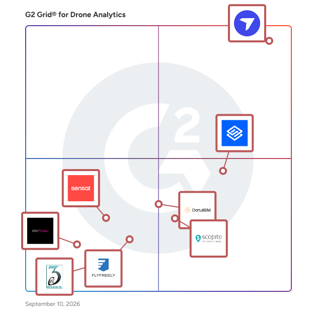
G2 Grid® for Drone Analytics Software

G2 Grid® for Drone Analytics Software plotting products by satisfaction and market presence

Highlighted products: DroneDeploy, Sitemark, DatuBIM, Scopito, Sensat, FlyFreely, DigitRobo, and MayaDrone.

Underlying data: [Grid® JSON](https://www.g2.com/categories/drone-analytics/grids.json?focus%5B%5D=dronedeploy&focus%5B%5D=sitemark&focus%5B%5D=datubim&focus%5B%5D=scopito&focus%5B%5D=sensat&focus%5B%5D=flyfreely&focus%5B%5D=digitrobo&focus%5B%5D=mayadrone)

DroneDeploy

DroneDeploy powers field teams with robotics and AI. As the only platform that combines robotic automation, AI agents and truly unified reality capture, DroneDeploy allows critical industries to operate with speed and confidence. From construction and energy to agriculture, the world’s largest companies use DroneDeploy to simplify field operations, improve safety and make smarter decisions, faster. By combining aerial drones, 360 and fixed cameras, ground robots and proprietary AI, we’re bringing the power of automation and visual intelligence to all stakeholders, from the field to the boardroom.

Average Rating: 4.6/5.0

Total Reviews: 116

Who Is the Company Behind DroneDeploy?

  • Seller: DroneDeploy
  • Year Founded: 2013
  • HQ Location: San Francisco, US
  • Twitter: @DroneDeploy
    34,433 Twitter followers
  • LinkedIn® Page: www.linkedin.com
    386 employees on LinkedIn®

Who Uses This Product?

  • Who Uses This: Project Engineer, VDC Manager
  • Top Industries: Construction, Architecture & Planning
  • Company Size: 42% Medium, 42% Small

What Do G2 Reviewers Say About DroneDeploy?

AI-generated summary from verified user reviews

Pros
  • Users appreciate the ease of use of DroneDeploy, enjoying intuitive features for planning and collaboration.
  • Users praise the user-friendly interface and exceptional customer service of DroneDeploy, enhancing their overall experience.
  • Users value the responsive and knowledgeable customer support from DroneDeploy, enhancing their overall experience and productivity.
  • Users value the intuitive flight planning and rapid map processing of DroneDeploy, significantly enhancing their workflow efficiency.
  • Users love the easy sharing capabilities of DroneDeploy, enabling seamless collaboration and effective project management.
Cons
  • Users find the service expensive, leading to difficulties in retention and understanding pricing plans.
  • Users report missing features like bulk GCP processing and account restrictions, making tasks tedious and less efficient.
  • Users report upload issues with DroneDeploy, finding it sometimes slow and complicating their project workflows.
  • Users face limited access to important logs and support, hindering their ability to effectively utilize DroneDeploy.

What Are Recent G2 Reviews of DroneDeploy?

What Are G2 Users Discussing About DroneDeploy?

Sitemark

Sitemark provides an all-in-one platform to boost productivity, quality, and performance of renewable energy projects across their entire lifecycle, powered by AI and robotics. By empowering Asset Managers, EPCs, and O&M Teams, Sitemark ensures that solar sites are constructed to the highest standards and continue to deliver exceptional results throughout their lifecycle. With over 8,500 solar sites, 100 GWp, and deployments in 75+ countries, Sitemark is the trusted partner for leading renewable energy companies worldwide, enabling scalable and successful solar operations on a global scale.

Average Rating: 4.9/5.0

Total Reviews: 30

Who Is the Company Behind Sitemark?

  • Seller: Sitemark
  • Year Founded: 2016
  • HQ Location: Leuven, BE
  • LinkedIn® Page: www.linkedin.com
    55 employees on LinkedIn®

Who Uses This Product?

  • Top Industries: Renewables & Environment, Oil & Energy
  • Company Size: 63% Small, 27% Medium

What Do G2 Reviewers Say About Sitemark?

AI-generated summary from verified user reviews

Pros
  • Users rave about Sitemark's excellent customer support, praising their quick responses and helpful, flexible approach.
  • Users appreciate the exceptional responsiveness of SiteMark, enhancing collaboration and ensuring seamless project execution.
  • Users commend Sitemark for its efficiency improvement, noting exceptional support and streamlined solutions that enhance productivity.
  • Users appreciate the implementation ease of Sitemark, finding it user-friendly with excellent customer support throughout the process.
  • Users value the exceptional responsiveness and professionalism of SiteMark, enhancing efficiency and trust in solar project management.
Cons
  • Users face alignment issues with documents and images in Sitemark, though some have found workaround solutions.
  • Users face form complexity as document-image alignment issues occasionally disrupt their workflows, although workarounds are available.
  • Users find integration issues frustrating, making it difficult to connect valuable third-party applications effectively.
  • Users find the learning curve steep initially, but tutorials and support ease the process over time.
  • Users experience alignment issues with documents and images, leading to occasional incorrect string layouts but seek workaround solutions.

What Are Recent G2 Reviews of Sitemark?

DatuBIM

Datumate, founded in 2011, is a construction technology (contech) company that offers a SaaS, cloud-based photogrammetry solution for stakeholders across the construction project lifecycle. Our product DatuBIM was launched in 2020 and is used by construction, engineering, and departments of transportation (DOTs) in the United States, Europe, and Middle East. DatuBIM is designed specifically for infrastructure construction and heavy civil projects. It focuses on three main areas:mapping and measuring sites; tracking and monitoring projects; and reporting on project progress as well as comprehensive quality control. How does DatuBIM help our clients? Below we have listed several use cases that illustrate the time and money savings DatuBIM provides. 1. Time Savings with DatuBIM’s Automated Engineering Report: Cross Section Volume Report in Highway Expansion Project. The challenge for a project engineer on a heavy civil highway project is accurately tracking the required quantity of aggregates for each base layer. DatuBIM's Cross Section Volume Report offers an efficient solution by comparing surface design files and a precise 3D model of the highway to generate cut fill volumes at each station on the alignment. Automated reporting allows for as needed calculations during the lifecycle of the project. Benefits include improved accuracy, increased efficiency, cost optimization, and enhanced project control. By utilizing DatuBIM's Cross Section Volume Report, project engineers can streamline the process of analyzing and quantifying earthwork volumes in civil engineering projects. 2. Scaling Data: Cloud Based Data Processing and Storage to Eliminate Data Silo. The challenge for a resident engineer is accessing drone photogrammetry data confined to a surveyor's desktop computer. Transitioning to DatuBIM's cloud-based photogrammetry solution solves this challenge by providing centralized data storage, real-time accessibility, collaborative environment, easy data sharing, and scalability. With DatuBIM, the resident engineer can overcome limitations in accessing and sharing data, ensuring seamless collaboration, enhanced productivity, and accessing time sensitive data as needed. 3. Dispute Resolution: Avoiding Costly Mediation with Subcontractors. The project manager faced a challenge when a subcontractor claimed to have completed the precast storm water drain installation before the deadline. Using DatuBIM's time-stamped images and 3D models, the project manager reviewed drone flights and discovered visible gaps and unfinished sections, contradicting the subcontractor's claim. Armed with this evidence, they engaged in a transparent conversation, and the subcontractor acknowledged the incomplete installation, resolving the dispute. DatuBIM's accurate and objective documentation showcased its effectiveness in conflict resolution, providing visual evidence and facilitating fair resolutions in construction projects. 4. Mass Haul Analysis: Avoiding Costly Hauling Fees. Grade Control Managers can optimize material distribution on construction sites by using DatuBIM's Volume Grid Heatmap Report. By integrating design models and drone data, DatuBIM generates a volume grid and heatmap report. Project managers can analyze the heatmap to identify optimal material placement, minimizing haulage distances and reducing costs. Regular flights enable ongoing adjustments. The report saves money by reducing haulage fees and maximizing efficiency. DatuBIM's Volume Grid Heatmap Report enables better decisions, resulting in significant cost and time savings. It enhances project efficiency, budget management, and overall construction operations. 5. Optimized Reporting: Relieve Month End Backlogs. DatuBIM simplifies end-of-the-month reporting for project managers dealing with multiple stockpiles in highway gores. The platform allows easy grouping of stockpile data into a single report, eliminating manual consolidation. Project managers can integrate information on stockpile locations, quantities, and changes, and download a comprehensive spreadsheet report. This streamlines the reporting process, saves time, and ensures data accuracy. DatuBIM's capability to consolidate stockpiles into a downloadable spreadsheet greatly enhances efficiency in end-of-the-month reporting tasks for project managers.

Average Rating: 4.9/5.0

Total Reviews: 11

Who Is the Company Behind DatuBIM?

  • Seller: Datumate
  • Year Founded: 2012
  • HQ Location: Yoqneam , Israel
  • LinkedIn® Page: www.linkedin.com
    35 employees on LinkedIn®

Who Uses This Product?

  • Top Industries: Civil Engineering
  • Company Size: 45% Small, 36% Medium

What Are Recent G2 Reviews of DatuBIM?

Scopito

Scopito is a cloud-based platform for visual data management. It aids Utilities and DSPs in storing, analysing and sharing images from their visual inspections and provides an overview of their assets and the assets' condition. Scopito is not subscription-based, but rather customers pay a fixed amount per inspection stored on the platform, with the option of volume-based discounts. Scopito comes complete with powerful image analysis tools and smart keyboard shortcuts, to optimize the workflow for fault detection and management. Integrations to SAP systems is available. Additionally, customers have the option to outsource analysis to Scopito's team, which leverages Artificial Intelligence algorithms and subject matter experts for the task, and delivers results directly in the platform. Because the product is cloud-based, sharing inspections for review or analysis is easy. Additional users are free of charge, and companies can manage access levels as well as roles and rights themselves, directly from the platform. It is also possible to host Scopito on-premise. For deliveries, Scopito has a fully customizable reporting feature that exports to both PDF and CSV. For companies wishing to personalize the platform, Scopito offers a white-labeling solution. White-label clients can use the platform from a custom URL and with a specialized design as per their choice. ______ Scopito started it's career as a drone manufacturer under the name Danish Drones. However, the team's focus quickly shifted, and Danish Drones became Heliscope; a Drone Service Provider who developed their own image management software. In 2016 the software became the sole focus, and Heliscope sold it's inspections business to become Scopito. Today Scopito servers more than 7000 companies worldwide and has headquarters in Denmark and The United States.

Average Rating: 4.9/5.0

Total Reviews: 20

Who Is the Company Behind Scopito?

  • Seller: Scopito
  • Year Founded: 2014
  • HQ Location: Aarhus N, Danmark
  • Twitter: @Scopito
  • LinkedIn® Page: www.linkedin.com
    14 employees on LinkedIn®

Who Uses This Product?

  • Company Size: 70% Small, 13% Medium

What Are Recent G2 Reviews of Scopito?

What Are G2 Users Discussing About Scopito?

Sensat

Sensat is a visualisation platform enabling better collaboration and decision-making for all project teams involved. By collecting and delivering infrastructure data our platform translates the real world into a digital version. This enables physical industries to analyse and understand their built environments and make smarter decisions. Together with the likes of Aecom, Connect Plus, and Heathrow & Kier, we’re revolutionising the way we plan, build, and manage large civil infrastructure projects worth over £150bn.

Average Rating: 4.3/5.0

Total Reviews: 11

Who Is the Company Behind Sensat?

  • Seller: Sensat
  • Year Founded: 2017
  • HQ Location: London, England
  • Twitter: @sensat_ai
    3,695 Twitter followers
  • LinkedIn® Page: www.linkedin.com
    54 employees on LinkedIn®

Who Uses This Product?

  • Company Size: 45% Small, 36% Medium

What Are Recent G2 Reviews of Sensat?

FlyFreely

FlyFreely enables businesses and enterprises to start, scale and sustain their drone operations. Plan, execute and reconcile all your drone operations in one simple to use platform. We achieve this through our flexible platform technology that caters for any combination of operational and regulatory requirements. We can support all types of operations from simple VLOS to complex BVLOS operations like drone-in-a-box, delivery and urban air mobility. We tailor all data sources, rules, workflows, forms and reports to your specific country's regulatory requirements to make operating in one or multiple countries a breeze. Furthermore, the platform even enables offline planning and execution of missions to ensure you can operate anywhere in the world at anytime. Developed by formed commercial drone operators we understand the challenges faced by operators in the field. With FlyFreely you will spend less time on paperwork and more time flying.

Average Rating: 4.1/5.0

Total Reviews: 15

Who Is the Company Behind FlyFreely?

  • Seller: FlyFreely
  • Year Founded: 2017
  • HQ Location: Fortitude Valley, Queensland
  • Twitter: @FlyFreelyIO
    103 Twitter followers
  • LinkedIn® Page: www.linkedin.com
    13 employees on LinkedIn®

Who Uses This Product?

  • Company Size: 60% Small, 47% Medium

What Are Recent G2 Reviews of FlyFreely?

DigitRobo

DigitRobo is designed to fly in complex, narrow indoor and outdoor spaces, can perform surveillance, deployment, and deliver actionable insights.

Average Rating: 4.5/5.0

Total Reviews: 11

Who Is the Company Behind DigitRobo?

  • Seller: Digit7
  • Year Founded: 2021
  • HQ Location: Richardson, Texas
  • LinkedIn® Page: www.linkedin.com
    69 employees on LinkedIn®

Who Uses This Product?

  • Company Size: 55% Small, 36% Medium

What Are Recent G2 Reviews of DigitRobo?

MayaDrone

MayaDrone is an autonomous drone application for various industries like telecom, energy, construction, agriculture and supply chain and it not required any experienced in drone. Mobile Application to do all tasks automatically without human intervention. With one click drone will hoover up, survey for selected object or area and create a 3D model instantly which can be populated in your dedicated cloud folder. There are additional services like AI, image recognition by ML, on the flight calculation and more customization solution will support your projects.

Average Rating: 4.5/5.0

Total Reviews: 15

Who Is the Company Behind MayaDrone?

  • Seller: 3Cell
  • Year Founded: 2009
  • HQ Location: London, London
  • Twitter: @3cellInnovative
    10 Twitter followers
  • LinkedIn® Page: www.linkedin.com
    3 employees on LinkedIn®

Who Uses This Product?

  • Top Industries: Information Technology and Services
  • Company Size: 53% Large, 33% Small

What Are Recent G2 Reviews of MayaDrone?

ArcGIS Drone2Map

ArcGIS Drone2Map streamlines the creation of professional imagery products from drone-captured still imagery for visualization and analysis in ArcGIS.

Average Rating: 4.4/5.0

Total Reviews: 15

Who Is the Company Behind ArcGIS Drone2Map?

  • Seller: Esri
  • Year Founded: 1969
  • HQ Location: Redlands, CA
  • Twitter: @Esri
    188,738 Twitter followers
  • LinkedIn® Page: www.linkedin.com
    7,396 employees on LinkedIn®

Who Uses This Product?

  • Company Size: 53% Small, 27% Medium

What Are Recent G2 Reviews of ArcGIS Drone2Map?

What Are G2 Users Discussing About ArcGIS Drone2Map?

Mapware

Mapware is the future of drone mapping software. Generate bigger, better 3D maps in the cloud. With Mapware’s easy-to-use interface, anyone can turn 2D drone photos into photorealistic 3D environments using a process called photogrammetry. Powerful enough for the biggest challenges. Simple enough for any project. Whether you want to map one building, a dozen cell towers, a whole oil field, or even an entire city, Mapware is the best tool for the job. Our browser-based software is easy to access from any device.

Average Rating: 4.3/5.0

Total Reviews: 15

Who Is the Company Behind Mapware?

  • Seller: Mapware.ai
  • Year Founded: 2015
  • HQ Location: Washington, District of Columbia
  • LinkedIn® Page: www.linkedin.com
    19 employees on LinkedIn®

Who Uses This Product?

  • Company Size: 80% Small, 27% Medium

What Are Recent G2 Reviews of Mapware?

What Are G2 Users Discussing About Mapware?

Skyward.io

The Skyward platform connects all the people, projects, and equipment involved in your drone program into one efficient workflow. Companies and fleet operators configure Skyward to meet their business requirements in order to scale faster and easily manage complex processes.

Average Rating: 4.1/5.0

Total Reviews: 7

Who Is the Company Behind Skyward.io?

Who Uses This Product?

  • Company Size: 86% Small, 14% Medium

What Are Recent G2 Reviews of Skyward.io?

What Are G2 Users Discussing About Skyward.io?

Delta Drone

Delta Drone is a French UAV manufacturer company.Delta Drone offers to its customers a complete solution of aerial analysis collecting the automated processing of acquired data, relying on its proprietary cloud solution.

Average Rating: 4.0/5.0

Total Reviews: 5

Who Is the Company Behind Delta Drone?

  • Seller: Delta Drone
  • Year Founded: 2011
  • HQ Location: Cannes, FR
  • LinkedIn® Page: www.linkedin.com
    17 employees on LinkedIn®
  • Ownership: EPA: ALDR

Who Uses This Product?

  • Company Size: 60% Medium, 40% Small

What Are Recent G2 Reviews of Delta Drone?

HUVR

Produces the richest set of reports, customized to what each constituent within an organization needs to perform their job.

Average Rating: 4.2/5.0

Total Reviews: 5

Who Is the Company Behind HUVR?

  • Seller: HUVR
  • Year Founded: 2014
  • HQ Location: Austin, US
  • LinkedIn® Page: www.linkedin.com
    21 employees on LinkedIn®

Who Uses This Product?

  • Company Size: 40% Medium, 40% Small

What Are Recent G2 Reviews of HUVR?

Aviotix

Aviotix delivers secure, production-ready software built on deep IT and AI expertise. Our team combines senior technical leadership with disciplined engineering execution, enabling rapid innovation while meeting enterprise standards for reliability, security, and regulatory compliance.

Average Rating: 4.6/5.0

Total Reviews: 4

Who Is the Company Behind Aviotix?

  • Seller: Aviotix
  • Year Founded: 2025
  • HQ Location: Dublin, IE
  • LinkedIn® Page: www.linkedin.com
    2 employees on LinkedIn®

Who Uses This Product?

  • Company Size: 50% Medium, 50% Small

What Are Recent G2 Reviews of Aviotix?

BlueVu

BlueVu allows for 360 degree navigation of the asset and delivers the precise UAV data and imagery (both high definition and thermal) location on the asset and vantage points that the user wishes to observe. This allows for a complete and detailed inspection of the entire asset to be performed, including aerial overviews, zoom in to inspect anomalies, annotate and generate custom reports right out of the software.

Average Rating: 4.4/5.0

Total Reviews: 4

Who Is the Company Behind BlueVu?

  • Seller: Qii.AI
  • Year Founded: 2014
  • HQ Location: Toronto, CA
  • Twitter: @Ind_SkyWorks
    703 Twitter followers
  • LinkedIn® Page: www.linkedin.com
    10 employees on LinkedIn®

Who Uses This Product?

  • Company Size: 50% Small, 25% Large

What Are Recent G2 Reviews of BlueVu?

What Are G2 Users Discussing About BlueVu?

Bijou Barry
BB
Researched and written by Bijou Barry
Updated October 3, 2024