Best GIS Software - Page 3

How Many GIS Software Products Does G2 Track?

Total Products under this Category: 414

Category Stats (Sep 2026)

  • Average Rating: 4.29/5 The average rating of products in this category, based on all submitted ratings
  • Top Trending Product: Smappen (+9.51%) - Among all products in this category, Smappen recorded the largest rating increase compared to last month

Last updated: September 01, 2026

How Does G2 Rank GIS Software Products?

Why You Can Trust G2's Software Rankings:

  • 30 Analysts and Data Experts
  • 8,100+ Authentic Reviews
  • 414+ Products
  • Unbiased Rankings

G2's software rankings are built on verified user reviews, rigorous moderation, and a consistent research methodology maintained by a team of analysts and data experts. Each product is measured using the same transparent criteria, with no paid placement or vendor influence. While reviews reflect real user experiences, which can be subjective, they offer valuable insight into how software performs in the hands of professionals. Together, these inputs power the G2 Score, a standardized way to compare tools within every category.

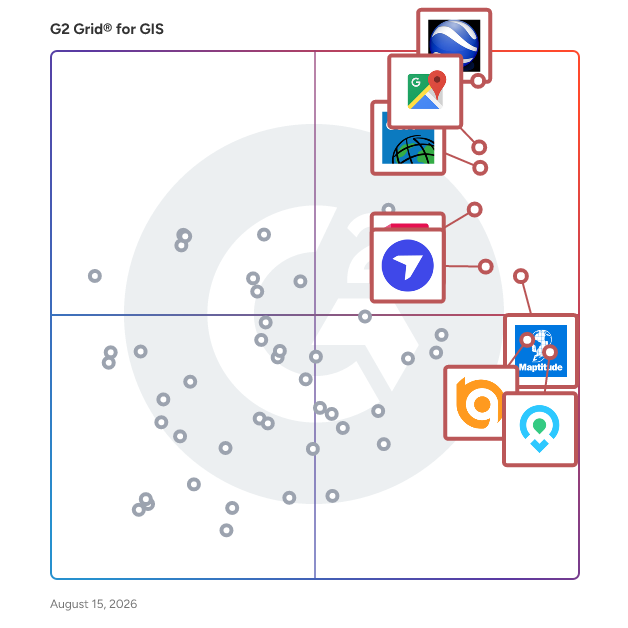
G2 Grid® for GIS Software

G2 Grid® for GIS Software plotting products by satisfaction and market presence

Highlighted products: Google Earth Pro, Google Maps Platform, Esri ArcGIS, AutoCAD, Maptitude, DroneDeploy, Mapme, and BatchGeo.

Underlying data: [Grid® JSON](https://www.g2.com/categories/gis/grids.json?focus%5B%5D=google-earth-pro&focus%5B%5D=google-maps-platform&focus%5B%5D=esri-arcgis&focus%5B%5D=autocad&focus%5B%5D=maptitude&focus%5B%5D=dronedeploy&focus%5B%5D=mapme&focus%5B%5D=batchgeo)

OpenStreetMap

OpenStreetMap (OSM) is a collaborative project that creates a free, editable map of the world, maintained by a community of volunteers. Established in 2004, OSM allows users to contribute and update data about roads, trails, cafés, railway stations, and more, utilizing tools like aerial imagery and GPS devices. Key Features and Functionality: - Editable Map Data: Users can add and modify map information, ensuring up-to-date and accurate representations of geographic areas. - Diverse Data Inclusion: OSM encompasses a wide range of data, including roads, buildings, addresses, points of interest, and natural features. - Community-Driven Contributions: With nearly 5 million registered users and over 1 million active contributors worldwide, OSM thrives on local knowledge and collective effort. - Open Data License: All map data is freely available under the Open Database License, allowing unrestricted use and distribution with proper attribution. Primary Value and User Solutions: OpenStreetMap provides an open-source alternative to proprietary mapping services, offering free access to comprehensive and customizable geographic data. It empowers individuals, organizations, and developers to create tailored maps, support navigation applications, and conduct geospatial analyses without licensing fees. OSM's emphasis on local knowledge ensures detailed and accurate mapping, particularly in areas underserved by commercial mapping services. Additionally, its open data model fosters innovation and collaboration across various sectors, including humanitarian aid, urban planning, and transportation.

Average Rating: 3.9/5.0

Total Reviews: 18

How Do G2 Users Rate OpenStreetMap?

  • Data Capture: 7.7/10 (Category avg: 8.6/10)
  • Data Visualization: 8.5/10 (Category avg: 8.6/10)
  • Ease of Use: 8.5/10 (Category avg: 8.4/10)
  • Spatial Analysis: 7.8/10 (Category avg: 8.4/10)

Who Is the Company Behind OpenStreetMap?

  • Seller: OpenStreetMap
  • HQ Location: Netherlands
  • Twitter: @openstreetmap
    83,242 Twitter followers
  • LinkedIn® Page: www.linkedin.com
    99 employees on LinkedIn®

Who Uses This Product?

  • Company Size: 47% Small, 37% Large

What Do G2 Reviewers Say About OpenStreetMap?

AI-generated summary from verified user reviews

Pros
  • Users appreciate the easy integration of OpenStreetMap, making it a flexible choice for various projects and portals.
  • Users highly value the free access to OpenStreetMap, enjoying its flexibility and powerful offline capabilities.
  • Users love the flexibility and power of OpenStreetMap, appreciating its offline capabilities and integration ease.
  • Users praise OpenStreetMap for its powerful tools, flexibility, and offline capabilities, all while being free.

What Are Recent G2 Reviews of OpenStreetMap?

What Are G2 Users Discussing About OpenStreetMap?

MapInfo Pro

Location-based decisions: Explore, model and act with confidence. Harness the power of sophisticated mapping and geographical analysis software to make intelligent and productive business decisions. Location adds complexity to many decisions, and mistakes are too expensive for a “trial and error” approach. With MapInfo Pro, customers can easily identify – and make better decisions on – people, places, and patterns of interest. More and more people need to explore, model and act with confidence on… - Site selection - Asset management - Demand management - Risk management/ service resource allocation MapInfo Pro delivers: 1) An all-in-one solution A full-featured desktop solution to prepare data for web mapping applications and create presentation quality maps in a familiar environment that combines data analysis, visual insights, and map publishing. - Data analysis - Visual insights - Map publishing 2) MapInfo Marketplace Enhance your location analytics with the MapInfo Marketplace. Bring analytics to life and solve your specific business needs with customized apps that are released and updated continuously. 3) Team MapInfo Pro supports the larger team of business experts, database experts, and developers who collaborate to deliver “self-serve” decision tools across the entire organization allowing location analysts to focus on special projects and creating templates for others to use. 4) Community The MapInfo community is your professional peer group of location analysts who can provide ideas, tips and tricks, and help guide the future development of MapInfo Pro Make the move to MapInfo Pro v2021 and join the MapInfo Pro community. Together, we’ll take a new, exciting journey as we collaborate to improve the future of mapping analytics.

Average Rating: 4.1/5.0

Total Reviews: 107

How Do G2 Users Rate MapInfo Pro?

  • Data Capture: 8.7/10 (Category avg: 8.6/10)
  • Data Visualization: 8.3/10 (Category avg: 8.6/10)
  • Ease of Use: 7.9/10 (Category avg: 8.4/10)
  • Spatial Analysis: 8.2/10 (Category avg: 8.4/10)

Who Is the Company Behind MapInfo Pro?

  • Seller: Precisely
  • HQ Location: Burlington, Massachusetts
  • Twitter: @PreciselyData
    3,963 Twitter followers
  • LinkedIn® Page: www.linkedin.com
    3,046 employees on LinkedIn®

Who Uses This Product?

  • Top Industries: Civil Engineering, Telecommunications
  • Company Size: 46% Large, 28% Medium

What Are Recent G2 Reviews of MapInfo Pro?

What Are G2 Users Discussing About MapInfo Pro?

ArcGIS Navigator

Navigator for ArcGIS is a mobile app that gets your field workforce where it needs to be, unlocking efficiency and improving reliability.

Average Rating: 4.0/5.0

Total Reviews: 36

How Do G2 Users Rate ArcGIS Navigator?

  • Data Capture: 9.0/10 (Category avg: 8.6/10)
  • Data Visualization: 8.9/10 (Category avg: 8.6/10)
  • Ease of Use: 7.7/10 (Category avg: 8.4/10)
  • Spatial Analysis: 9.0/10 (Category avg: 8.4/10)

Who Is the Company Behind ArcGIS Navigator?

  • Seller: Esri
  • Year Founded: 1969
  • HQ Location: Redlands, CA
  • Twitter: @Esri
    188,738 Twitter followers
  • LinkedIn® Page: www.linkedin.com
    7,396 employees on LinkedIn®

Who Uses This Product?

  • Top Industries: Information Technology and Services
  • Company Size: 47% Small, 34% Medium

What Are Recent G2 Reviews of ArcGIS Navigator?

What Are G2 Users Discussing About ArcGIS Navigator?

Loqate

GBG Loqate offers a suite of global Address Verification solutions to capture, verify and enrich customer data to eliminate friction, improve data quality, reduce fraud and enhance customer experience. GBG Loqate is trusted by over 20,000 top brands like IBM, Mastercard, ASOS, Oracle and Sephora for global data coverage that delivers local precision, even in hard-to-address markets. GBG Loqate's Address Capture revolutionises address lookup with intuitive suggestions, verified address data, and auto-correction to ensure data accuracy at the point of entry. Address Verify corrects, parses, formats and enriches address data; offering unmatched precision across 250 countries & territories with local address format customisation. Our AI parsing technology significantly improves address match rates & uplift capability. Additionally, GBG Loqate's Phone & Email Validation safeguards data integrity with real-time verification, minimising errors and potential fraudulent activity. GBG Loqate's Store Finder allows your customers to quickly find physical locations anywhere across the globe. GBG Loqate is the world’s leading address verification provider, helping you reach customers the first time, every time.

Average Rating: 4.4/5.0

Total Reviews: 46

How Do G2 Users Rate Loqate?

  • Ease of Use: 8.8/10 (Category avg: 8.4/10)

Who Is the Company Behind Loqate?

  • Seller: GBG Plc
  • Company Website:
  • Year Founded: 1989
  • HQ Location: Chester, United Kingdom
  • Twitter: @GBGplc
    3,058 Twitter followers
  • LinkedIn® Page: www.linkedin.com
    1,377 employees on LinkedIn®

Who Uses This Product?

  • Company Size: 54% Small, 33% Medium

What Do G2 Reviewers Say About Loqate?

AI-generated summary from verified user reviews

Pros
  • Users find the ease of use in Loqate beneficial for quickly filling in details with helpful suggestions.
  • Users value the reliable and accurate address verification from Loqate, enhancing data quality and minimizing delivery errors.
  • Users commend Loqate for its reliable and accurate address verification, significantly reducing shipping errors and enhancing data quality.
  • Users praise the excellent customer support from Loqate, contributing to an overall positive implementation experience.
  • Users value the reliable and accurate address verification of Loqate, enhancing data quality and reducing errors.
Cons
  • Users note the expensive pricing of Loqate, making it less accessible for smaller businesses.
  • Users find the high cost of Loqate challenging, especially for smaller businesses needing budget-friendly options.
  • Users report geographical limitations with Loqate, noting its range is not as extensive as competitors like Google.
  • Users face integration issues with Loqate, finding it less straightforward compared to other platforms like Google.
  • Users find the address range sub par compared to competitors and lack support for taxation is disappointing.

What Are Recent G2 Reviews of Loqate?

What Are G2 Users Discussing About Loqate?

Surfer

Surfer® is a full-function 2D and 3D mapping, modeling, and analysis software package for scientists and engineers. Surfer's sophisticated interpolation engine quickly transforms XYZ and XYZC data into publication-quality maps. Virtually every aspect of the map is customizable. Enhance maps with profiles, legends, titles and labels, faults and breaklines, or external maps from any web mapping service. Surfer is used extensively by geologists, geophysicists, hydrologists, archaeologists, oceanographers, biologists, consultants, engineers, and many others across the globe.

Average Rating: 4.6/5.0

Total Reviews: 124

How Do G2 Users Rate Surfer?

  • Data Capture: 7.8/10 (Category avg: 8.6/10)
  • Data Visualization: 9.0/10 (Category avg: 8.6/10)
  • Ease of Use: 8.7/10 (Category avg: 8.4/10)
  • Spatial Analysis: 8.5/10 (Category avg: 8.4/10)

Who Is the Company Behind Surfer?

  • Seller: Golden Software
  • Year Founded: 1983
  • HQ Location: Golden, CO
  • Twitter: @GoldenSoftware1
    780 Twitter followers
  • LinkedIn® Page: www.linkedin.com
    32 employees on LinkedIn®

Who Uses This Product?

  • Top Industries: Environmental Services, Oil & Energy
  • Company Size: 53% Small, 26% Medium

What Are Recent G2 Reviews of Surfer?

What Are G2 Users Discussing About Surfer?

Maptive

Maptive is a comprehensive set of mapping tools built with users in mind. Our mapping software provides businesses from small non-profits to enterprise-level corporations with a wide range of geospatial analysis and data visualization capabilities. Upload location data from spreadsheets or CRMs to Maptive's platform and apply our features to quickly create custom maps, including heat maps, color-coded pin maps, sales territory maps, optimized routes and directions, and demographic maps.

Average Rating: 4.7/5.0

Total Reviews: 34

How Do G2 Users Rate Maptive?

  • Data Capture: 8.8/10 (Category avg: 8.6/10)
  • Data Visualization: 9.5/10 (Category avg: 8.6/10)
  • Ease of Use: 9.2/10 (Category avg: 8.4/10)
  • Spatial Analysis: 9.3/10 (Category avg: 8.4/10)

Who Is the Company Behind Maptive?

  • Seller: Maptive
  • Year Founded: 2013
  • HQ Location: San Francisco, CA
  • Twitter: @Maptive
    572 Twitter followers
  • LinkedIn® Page: www.linkedin.com
    5 employees on LinkedIn®

Who Uses This Product?

  • Company Size: 66% Small, 29% Medium

What Do G2 Reviewers Say About Maptive?

AI-generated summary from verified user reviews

Pros
  • Users value the quick and helpful customer support from Maptive, enhancing the overall user experience significantly.
  • Users value the ease of use of Maptive, enabling quick map creation and data analysis without extensive training.
  • Users appreciate Maptive's excellent service, citing quick support and helpful responses that enhance their experience.
  • Users value the powerful and easy-to-use features of Maptive, enabling effective data visualization and quicker decision-making.
  • Users find Maptive's helpful support invaluable, improving decision-making speed and enhancing map presentation for stakeholders.
Cons
  • Users face some learning difficulty initially, but tutorials and live chat help ease the transition swiftly.

What Are Recent G2 Reviews of Maptive?

What Are G2 Users Discussing About Maptive?

Citymapper

Citymapper is building the best app (http://citymapper.com/apps), with the best routing, and the best data in the cities where we can make a difference.

Average Rating: 4.6/5.0

Total Reviews: 18

How Do G2 Users Rate Citymapper?

  • Data Capture: 9.3/10 (Category avg: 8.6/10)
  • Data Visualization: 8.3/10 (Category avg: 8.6/10)
  • Ease of Use: 9.7/10 (Category avg: 8.4/10)
  • Spatial Analysis: 9.0/10 (Category avg: 8.4/10)

Who Is the Company Behind Citymapper?

  • Seller: Citymapper
  • HQ Location: London, London
  • Twitter: @Citymapper
    23,847 Twitter followers
  • LinkedIn® Page: www.linkedin.com
    50 employees on LinkedIn®

Who Uses This Product?

  • Company Size: 71% Small, 24% Large

What Are Recent G2 Reviews of Citymapper?

What Are G2 Users Discussing About Citymapper?

Apache Spatial Information System

Apache Spatial Information System (SIS) is a free, open-source Java library designed for developing geospatial applications. It provides data structures for geographic features and associated metadata, along with methods to manipulate these structures. As an implementation of GeoAPI 3.0.2 interfaces, SIS is suitable for both desktop and server applications. Key Features and Functionality: - Metadata Handling: Supports the creation of metadata objects compliant with OGC/ISO international standards, facilitating interoperability and data sharing. - Coordinate Reference Systems (CRS): Enables the construction and transformation of CRS definitions, allowing for accurate geospatial data representation and conversion between different coordinate systems. - Raster Processing: Offers multi-threaded raster reprojection and isoline computation, enhancing the efficiency of processing large raster datasets. - Data Format Support: Provides reading and writing capabilities for various geospatial data formats, including GeoTIFF, NetCDF, ESRI formats, and more, ensuring compatibility with diverse data sources. - Unit Conversion: Implements JSR-385 for parsing, formatting, and converting measurement units, aiding in precise geospatial calculations. - Geodetic Operations: Supports various map projections such as Mercator, Transverse Mercator, Lambert Conic Conformal, and stereographic, essential for accurate mapping and spatial analysis. - Geohashes and MGRS: Provides encoding and decoding of geographic coordinates using Geohashes and the Military Grid Reference System (MGRS), facilitating efficient spatial indexing and location referencing. Primary Value and User Solutions: Apache SIS addresses the need for a standardized and comprehensive geospatial library in Java, enabling developers to build applications that require precise spatial data handling. By adhering to international standards, it ensures interoperability between different geospatial systems and datasets. Its modular architecture allows users to integrate specific functionalities as needed, making it a versatile tool for tasks ranging from metadata management to complex geodetic computations. This empowers organizations to effectively manage, analyze, and visualize geospatial information, supporting decision-making processes across various domains.

Average Rating: 4.4/5.0

Total Reviews: 11

How Do G2 Users Rate Apache Spatial Information System?

  • Data Capture: 8.8/10 (Category avg: 8.6/10)
  • Data Visualization: 8.8/10 (Category avg: 8.6/10)
  • Ease of Use: 7.9/10 (Category avg: 8.4/10)
  • Spatial Analysis: 9.2/10 (Category avg: 8.4/10)

Who Is the Company Behind Apache Spatial Information System?

Who Uses This Product?

  • Company Size: 73% Small, 18% Large

What Do G2 Reviewers Say About Apache Spatial Information System?

AI-generated summary from verified user reviews

Pros
  • Users value the complete and modular Java tools for effective management of geospatial data and coordinate systems.
  • Users value the complete and modular suite of tools in Apache Spatial Information System for managing geospatial data effectively.
Cons
  • Users find the learning difficulty of Apache Spatial Information System challenging due to its technical nature and complex documentation.
  • Users find the lack of tutorials challenging, making it hard for beginners to navigate the technical tool effectively.
  • Users find the technical complexity and challenging documentation of Apache Spatial Information System difficult for beginners.

What Are Recent G2 Reviews of Apache Spatial Information System?

What Are G2 Users Discussing About Apache Spatial Information System?

Geopointe

Geopointe is the leading geolocation solution built exclusively for Salesforce. Turn your CRM data into actionable territory maps, optimized routes, and smarter field execution—without leaving Salesforce. Sales teams use Geopointe to: Visualize accounts, leads, and opportunities on interactive maps Optimize routes and reduce drive time Plan territories with precision Improve field productivity and pipeline coverage Managers gain real-time visibility into field activity, while admins and developers get powerful, flexible configuration options directly inside Salesforce. Trusted by companies around the world, Geopointe helps revenue teams work smarter in the field and close more business. Start a free 15-day trial on the Salesforce AppExchange and see your data on the map in minutes.

Average Rating: 4.2/5.0

Total Reviews: 276

How Do G2 Users Rate Geopointe?

  • Data Capture: 8.6/10 (Category avg: 8.6/10)
  • Data Visualization: 9.0/10 (Category avg: 8.6/10)
  • Ease of Use: 8.0/10 (Category avg: 8.4/10)
  • Spatial Analysis: 9.1/10 (Category avg: 8.4/10)

Who Is the Company Behind Geopointe?

  • Seller: Ascent Cloud
  • Company Website:
  • Year Founded: 2020
  • HQ Location: Detroit, US
  • Twitter: @ascent_cloud
    59 Twitter followers
  • LinkedIn® Page: www.linkedin.com
    77 employees on LinkedIn®

Who Uses This Product?

  • Who Uses This: Salesforce Admin
  • Top Industries: Non-Profit Organization Management, Financial Services
  • Company Size: 46% Medium, 39% Small

What Do G2 Reviewers Say About Geopointe?

AI-generated summary from verified user reviews

Pros
  • Users value Geopointe's efficient mapping features, enabling easy route mapping, heat maps, and streamlined store locator searches.
  • Users value the customization options in Geopointe, particularly for efficient route mapping and heat map updates.
  • Users find ease of learning with Geopointe, benefiting from quick setup and user-friendly features like heat maps.
  • Users find the ease of setup in Geopointe highly convenient, enabling quick start to utilizing the product.
  • Users value the ease of use of Geopointe, making route mapping and updates simple and efficient.
Cons
  • Users experience app bugs with Geopointe, leading to frustration as functionalities frequently fail to work as expected.
  • Users often face app instability with Geopointe, as many features do not function as expected.
  • Users find difficult learning curves with Geopointe, making it challenging to fully utilize the software's capabilities.
  • Users face email issues with renewal notices being filtered to spam, causing missed deadlines and inflexible policies.
  • Users note that improvement is needed in Geopointe's performance and usability for a smoother experience.

What Are Recent G2 Reviews of Geopointe?

What Are G2 Users Discussing About Geopointe?

GE Smallworld

GE's comprehensive suite of integrated tools enable customers to lower the cost of ownership, simplify critical network infrastructures and deliver the flexibility required to meet dynamic network requirements.

Average Rating: 3.8/5.0

Total Reviews: 16

How Do G2 Users Rate GE Smallworld?

  • Data Capture: 8.3/10 (Category avg: 8.6/10)
  • Data Visualization: 8.3/10 (Category avg: 8.6/10)
  • Ease of Use: 5.4/10 (Category avg: 8.4/10)
  • Spatial Analysis: 8.3/10 (Category avg: 8.4/10)

Who Is the Company Behind GE Smallworld?

Who Uses This Product?

  • Top Industries: Utilities
  • Company Size: 59% Large, 24% Medium

What Are Recent G2 Reviews of GE Smallworld?

What Are G2 Users Discussing About GE Smallworld?

ArcGIS Desktop

Integrated collection of GIS software products; provides a standards-based platform for spatial analysis, data management, and mapping.

Average Rating: 4.5/5.0

Total Reviews: 17

How Do G2 Users Rate ArcGIS Desktop?

  • Data Capture: 8.9/10 (Category avg: 8.6/10)
  • Data Visualization: 8.3/10 (Category avg: 8.6/10)
  • Ease of Use: 8.5/10 (Category avg: 8.4/10)
  • Spatial Analysis: 8.5/10 (Category avg: 8.4/10)

Who Is the Company Behind ArcGIS Desktop?

  • Seller: Esri
  • Year Founded: 1969
  • HQ Location: Redlands, CA
  • Twitter: @Esri
    188,738 Twitter followers
  • LinkedIn® Page: www.linkedin.com
    7,396 employees on LinkedIn®

Who Uses This Product?

  • Company Size: 50% Small, 33% Medium

What Are Recent G2 Reviews of ArcGIS Desktop?

What Are G2 Users Discussing About ArcGIS Desktop?

ArcGIS for Office

Make maps in Microsoft Excel and further the power of ArcGIS Online and ArcGIS Enterprise. ArcGIS Maps for Office puts Excel data in the context of location. Use location intelligence to transform your graphs and charts into interactive maps directly in Microsoft Excel to see data from another perspective. Then, use Microsoft PowerPoint to share your map.

Average Rating: 4.0/5.0

Total Reviews: 16

How Do G2 Users Rate ArcGIS for Office?

  • Ease of Use: 6.9/10 (Category avg: 8.4/10)

Who Is the Company Behind ArcGIS for Office?

  • Seller: Esri
  • Year Founded: 1969
  • HQ Location: Redlands, CA
  • Twitter: @Esri
    188,738 Twitter followers
  • LinkedIn® Page: www.linkedin.com
    7,396 employees on LinkedIn®

Who Uses This Product?

  • Company Size: 65% Medium, 24% Small

What Are Recent G2 Reviews of ArcGIS for Office?

What Are G2 Users Discussing About ArcGIS for Office?

LocationIQ

Trusted by 100K+ developers, LocationIQ offers a suite of services that provides for powerful geolocation experiences that are reliable, affordable, and scalable. LocationIQ provides: 1. Address APIs: Reverse geocoding, forward geocoding, Autocomplete 2. Map APIs: Raster, Vector Map tiles, Dynamic and Static Maps 3. Routing APIs: Routing, Distance Matrix, Map-matching, Nearest and more

Average Rating: 4.5/5.0

Total Reviews: 23

How Do G2 Users Rate LocationIQ?

  • Data Capture: 8.3/10 (Category avg: 8.6/10)
  • Data Visualization: 8.1/10 (Category avg: 8.6/10)
  • Ease of Use: 8.9/10 (Category avg: 8.4/10)
  • Spatial Analysis: 7.4/10 (Category avg: 8.4/10)

Who Is the Company Behind LocationIQ?

  • Seller: Unwired Labs
  • Year Founded: 2013
  • HQ Location: Hyderabad, TS
  • Twitter: @location_iq
    79 Twitter followers
  • LinkedIn® Page: www.linkedin.com
    6 employees on LinkedIn®

Who Uses This Product?

  • Top Industries: Information Technology and Services
  • Company Size: 36% Large, 36% Small

What Are Recent G2 Reviews of LocationIQ?

What Are G2 Users Discussing About LocationIQ?

Octave GeoMedia

GeoMedia is a powerful, flexible GIS management platform that lets you aggregate data from a variety of sources and analyze them in unison to extract clear, actionable information. It provides simultaneous access to geospatial data in almost any form and displays it in a single unified map view for efficient processing, analysis, presentation, and sharing. GeoMedia’s functionality makes it ideal for extracting information from an array of dynamically changing data to support making informed, smarter decisions.

Average Rating: 3.9/5.0

Total Reviews: 22

How Do G2 Users Rate Octave GeoMedia?

  • Data Capture: 8.1/10 (Category avg: 8.6/10)
  • Data Visualization: 8.3/10 (Category avg: 8.6/10)
  • Ease of Use: 7.7/10 (Category avg: 8.4/10)
  • Spatial Analysis: 8.5/10 (Category avg: 8.4/10)

Who Is the Company Behind Octave GeoMedia?

Who Uses This Product?

  • Company Size: 58% Small, 31% Medium

What Are Recent G2 Reviews of Octave GeoMedia?

What Are G2 Users Discussing About Octave GeoMedia?

Land id (formerly MapRight)

Land id™ & Land id Pro enables real estate professionals, ranchers, farmers, appraisers, builders, landowners, and anyone curious about land to discover extensive private parcel data, create & showcase powerful, shareable, interactive maps.

Average Rating: 4.3/5.0

Total Reviews: 15

How Do G2 Users Rate Land id (formerly MapRight)?

  • Data Capture: 8.9/10 (Category avg: 8.6/10)
  • Data Visualization: 8.3/10 (Category avg: 8.6/10)
  • Ease of Use: 8.8/10 (Category avg: 8.4/10)
  • Spatial Analysis: 8.3/10 (Category avg: 8.4/10)

Who Is the Company Behind Land id (formerly MapRight)?

  • Seller: Land id
  • Year Founded: 2014
  • HQ Location: Dallas, TX
  • Twitter: @landidofficial
    1,410 Twitter followers
  • LinkedIn® Page: www.linkedin.com
    50 employees on LinkedIn®

Who Uses This Product?

  • Company Size: 80% Small, 13% Medium

What Are Recent G2 Reviews of Land id (formerly MapRight)?

What Are G2 Users Discussing About Land id (formerly MapRight)?

Daniel Rivera
DR
Researched and written by Daniel Rivera
Updated March 4, 2025