Top Free GIS Software - Page 2

How Many GIS Software Products Does G2 Track?

Total Products under this Category: 415

Category Stats (Sep 2026)

  • Average Rating: 4.29/5 The average rating of products in this category, based on all submitted ratings
  • Top Trending Product: Smappen (+9.51%) - Among all products in this category, Smappen recorded the largest rating increase compared to last month

Last updated: September 01, 2026

How Does G2 Rank GIS Software Products?

Why You Can Trust G2's Software Rankings:

  • 30 Analysts and Data Experts
  • 8,100+ Authentic Reviews
  • 415+ Products
  • Unbiased Rankings

G2's software rankings are built on verified user reviews, rigorous moderation, and a consistent research methodology maintained by a team of analysts and data experts. Each product is measured using the same transparent criteria, with no paid placement or vendor influence. While reviews reflect real user experiences, which can be subjective, they offer valuable insight into how software performs in the hands of professionals. Together, these inputs power the G2 Score, a standardized way to compare tools within every category.

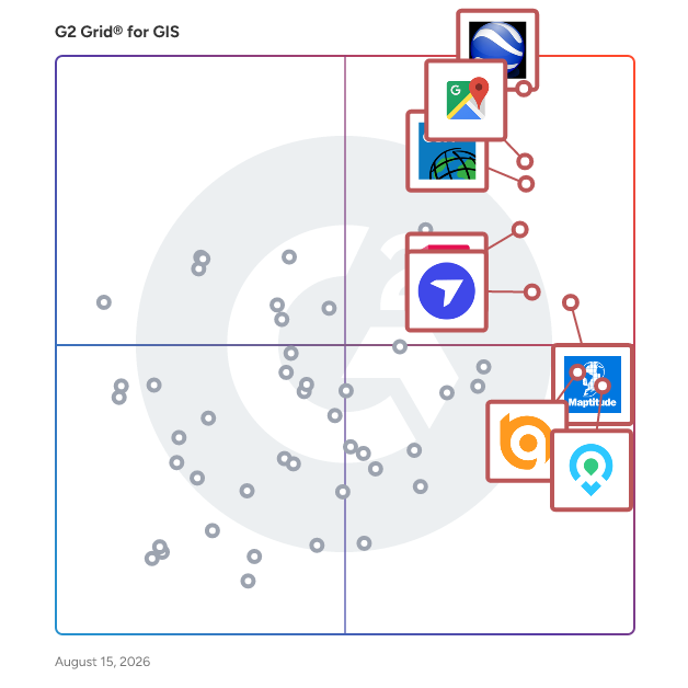
G2 Grid® for GIS Software

G2 Grid® for GIS Software plotting products by satisfaction and market presence

Highlighted products: Google Earth Pro, Google Maps Platform, Esri ArcGIS, AutoCAD, Maptitude, DroneDeploy, Mapme, and BatchGeo.

Underlying data: [Grid® JSON](https://www.g2.com/categories/gis/grids.json?focus%5B%5D=google-earth-pro&focus%5B%5D=google-maps-platform&focus%5B%5D=esri-arcgis&focus%5B%5D=autocad&focus%5B%5D=maptitude&focus%5B%5D=dronedeploy&focus%5B%5D=mapme&focus%5B%5D=batchgeo)

Loqate

GBG Loqate offers a suite of global Address Verification solutions to capture, verify and enrich customer data to eliminate friction, improve data quality, reduce fraud and enhance customer experience. GBG Loqate is trusted by over 20,000 top brands like IBM, Mastercard, ASOS, Oracle and Sephora for global data coverage that delivers local precision, even in hard-to-address markets. GBG Loqate's Address Capture revolutionises address lookup with intuitive suggestions, verified address data, and auto-correction to ensure data accuracy at the point of entry. Address Verify corrects, parses, formats and enriches address data; offering unmatched precision across 250 countries & territories with local address format customisation. Our AI parsing technology significantly improves address match rates & uplift capability. Additionally, GBG Loqate's Phone & Email Validation safeguards data integrity with real-time verification, minimising errors and potential fraudulent activity. GBG Loqate's Store Finder allows your customers to quickly find physical locations anywhere across the globe. GBG Loqate is the world’s leading address verification provider, helping you reach customers the first time, every time.

Average Rating: 4.4/5.0

Total Reviews: 46

How Do G2 Users Rate Loqate?

  • Ease of Use: 8.8/10 (Category avg: 8.4/10)

Who Is the Company Behind Loqate?

  • Seller: GBG Plc
  • Company Website:
  • Year Founded: 1989
  • HQ Location: Chester, United Kingdom
  • Twitter: @GBGplc
    3,058 Twitter followers
  • LinkedIn® Page: www.linkedin.com
    1,377 employees on LinkedIn®

Who Uses This Product?

  • Company Size: 54% Small, 33% Medium

What Do G2 Reviewers Say About Loqate?

AI-generated summary from verified user reviews

Pros
  • Users find the ease of use in Loqate beneficial for quickly filling in details with helpful suggestions.
  • Users value the reliable and accurate address verification from Loqate, enhancing data quality and minimizing delivery errors.
  • Users commend Loqate for its reliable and accurate address verification, significantly reducing shipping errors and enhancing data quality.
  • Users praise the excellent customer support from Loqate, contributing to an overall positive implementation experience.
  • Users value the reliable and accurate address verification of Loqate, enhancing data quality and reducing errors.
Cons
  • Users note the expensive pricing of Loqate, making it less accessible for smaller businesses.
  • Users find the high cost of Loqate challenging, especially for smaller businesses needing budget-friendly options.
  • Users report geographical limitations with Loqate, noting its range is not as extensive as competitors like Google.
  • Users face integration issues with Loqate, finding it less straightforward compared to other platforms like Google.
  • Users find the address range sub par compared to competitors and lack support for taxation is disappointing.

What Are Recent G2 Reviews of Loqate?

What Are G2 Users Discussing About Loqate?

Surfer

Surfer® is a full-function 2D and 3D mapping, modeling, and analysis software package for scientists and engineers. Surfer's sophisticated interpolation engine quickly transforms XYZ and XYZC data into publication-quality maps. Virtually every aspect of the map is customizable. Enhance maps with profiles, legends, titles and labels, faults and breaklines, or external maps from any web mapping service. Surfer is used extensively by geologists, geophysicists, hydrologists, archaeologists, oceanographers, biologists, consultants, engineers, and many others across the globe.

Average Rating: 4.6/5.0

Total Reviews: 124

How Do G2 Users Rate Surfer?

  • Data Capture: 7.8/10 (Category avg: 8.6/10)
  • Data Visualization: 9.0/10 (Category avg: 8.6/10)
  • Ease of Use: 8.7/10 (Category avg: 8.4/10)
  • Spatial Analysis: 8.5/10 (Category avg: 8.4/10)

Who Is the Company Behind Surfer?

  • Seller: Golden Software
  • Year Founded: 1983
  • HQ Location: Golden, CO
  • Twitter: @GoldenSoftware1
    780 Twitter followers
  • LinkedIn® Page: www.linkedin.com
    32 employees on LinkedIn®

Who Uses This Product?

  • Top Industries: Environmental Services, Oil & Energy
  • Company Size: 53% Small, 26% Medium

What Are Recent G2 Reviews of Surfer?

What Are G2 Users Discussing About Surfer?

Maptive

Maptive is a comprehensive set of mapping tools built with users in mind. Our mapping software provides businesses from small non-profits to enterprise-level corporations with a wide range of geospatial analysis and data visualization capabilities. Upload location data from spreadsheets or CRMs to Maptive's platform and apply our features to quickly create custom maps, including heat maps, color-coded pin maps, sales territory maps, optimized routes and directions, and demographic maps.

Average Rating: 4.7/5.0

Total Reviews: 34

How Do G2 Users Rate Maptive?

  • Data Capture: 8.8/10 (Category avg: 8.6/10)
  • Data Visualization: 9.5/10 (Category avg: 8.6/10)
  • Ease of Use: 9.2/10 (Category avg: 8.4/10)
  • Spatial Analysis: 9.3/10 (Category avg: 8.4/10)

Who Is the Company Behind Maptive?

  • Seller: Maptive
  • Year Founded: 2013
  • HQ Location: San Francisco, CA
  • Twitter: @Maptive
    572 Twitter followers
  • LinkedIn® Page: www.linkedin.com
    5 employees on LinkedIn®

Who Uses This Product?

  • Company Size: 66% Small, 29% Medium

What Do G2 Reviewers Say About Maptive?

AI-generated summary from verified user reviews

Pros
  • Users value the quick and helpful customer support from Maptive, enhancing the overall user experience significantly.
  • Users value the ease of use of Maptive, enabling quick map creation and data analysis without extensive training.
  • Users appreciate Maptive's excellent service, citing quick support and helpful responses that enhance their experience.
  • Users value the powerful and easy-to-use features of Maptive, enabling effective data visualization and quicker decision-making.
  • Users find Maptive's helpful support invaluable, improving decision-making speed and enhancing map presentation for stakeholders.
Cons
  • Users face some learning difficulty initially, but tutorials and live chat help ease the transition swiftly.

What Are Recent G2 Reviews of Maptive?

What Are G2 Users Discussing About Maptive?

Geopointe

Geopointe is the leading geolocation solution built exclusively for Salesforce. Turn your CRM data into actionable territory maps, optimized routes, and smarter field execution—without leaving Salesforce. Sales teams use Geopointe to: Visualize accounts, leads, and opportunities on interactive maps Optimize routes and reduce drive time Plan territories with precision Improve field productivity and pipeline coverage Managers gain real-time visibility into field activity, while admins and developers get powerful, flexible configuration options directly inside Salesforce. Trusted by companies around the world, Geopointe helps revenue teams work smarter in the field and close more business. Start a free 15-day trial on the Salesforce AppExchange and see your data on the map in minutes.

Average Rating: 4.2/5.0

Total Reviews: 276

How Do G2 Users Rate Geopointe?

  • Data Capture: 8.6/10 (Category avg: 8.6/10)
  • Data Visualization: 9.0/10 (Category avg: 8.6/10)
  • Ease of Use: 8.0/10 (Category avg: 8.4/10)
  • Spatial Analysis: 9.1/10 (Category avg: 8.4/10)

Who Is the Company Behind Geopointe?

  • Seller: Ascent Cloud
  • Company Website:
  • Year Founded: 2020
  • HQ Location: Detroit, US
  • Twitter: @ascent_cloud
    59 Twitter followers
  • LinkedIn® Page: www.linkedin.com
    77 employees on LinkedIn®

Who Uses This Product?

  • Who Uses This: Salesforce Admin
  • Top Industries: Non-Profit Organization Management, Financial Services
  • Company Size: 46% Medium, 39% Small

What Do G2 Reviewers Say About Geopointe?

AI-generated summary from verified user reviews

Pros
  • Users value Geopointe's efficient mapping features, enabling easy route mapping, heat maps, and streamlined store locator searches.
  • Users value the customization options in Geopointe, particularly for efficient route mapping and heat map updates.
  • Users find ease of learning with Geopointe, benefiting from quick setup and user-friendly features like heat maps.
  • Users find the ease of setup in Geopointe highly convenient, enabling quick start to utilizing the product.
  • Users value the ease of use of Geopointe, making route mapping and updates simple and efficient.
Cons
  • Users experience app bugs with Geopointe, leading to frustration as functionalities frequently fail to work as expected.
  • Users often face app instability with Geopointe, as many features do not function as expected.
  • Users find difficult learning curves with Geopointe, making it challenging to fully utilize the software's capabilities.
  • Users face email issues with renewal notices being filtered to spam, causing missed deadlines and inflexible policies.
  • Users note that improvement is needed in Geopointe's performance and usability for a smoother experience.

What Are Recent G2 Reviews of Geopointe?

What Are G2 Users Discussing About Geopointe?

Global Mapper

Global Mapper’s intuitive user interface and logical layout help smooth the learning curve and ensure that users will be up-and-running in no time. To add to the usability, nearly 400 file formats are supported for import and export. This all-in-one software allows users to complete their entire workflow within the same software with tools such as contour creation, watershed analysis, and multiband raster calculations. Top Tools Include: • Access to online data sources for streaming imagery, terrain and vector data • Immersive 3D visualization • Workflow automation with scripting • Site plan with cut and fill analysis • Generate terrain models (REM, DSM, and DEM) • Terrain analysis including contour generation and path profile Global Mapper Pro® expands upon the extensive functionality of the standard version of the application. Users can take advantage of the comprehensive collection of tools for advanced 3D analysis, lidar and photogrammetric point cloud processing, drone-collected image analysis, Python scripting methods, machine-learning integration and much more. Award-winning machine learning has been integrated with the beloved automatic point cloud classification. In addition to the built-in models for auto-classifying ground, building, vegetation and powerline points, custom classes can be created by users. Top Tools Include: • Pixels to Points: Photogrammetric toolset • Filtering and editing of lidar point clouds • Automatic classification of ground, vegetation, buildings, power lines, and poles • Terrain Painting • Solar analysis from loaded terrain and 3D features • Global Mapper Insight and Learning Engine: Deep-learning powered object detection and land cover classification Developed for both GIS professionals and map enthusiasts, Global Mapper® has all the functionality you need in a GIS software. Take GIS into the field with Global Mapper Mobile. This iOS and Android application makes viewing and collecting data on-the-go easy. • Display vector, raster, and elevation layers • Drawing, tracing and form-based collection • Connection to GNSS and GPS receivers • Terrain Analysis: contour creation, volume calculation and viewshed

Average Rating: 4.3/5.0

Total Reviews: 30

How Do G2 Users Rate Global Mapper?

  • Data Capture: 8.7/10 (Category avg: 8.6/10)
  • Data Visualization: 8.7/10 (Category avg: 8.6/10)
  • Ease of Use: 7.8/10 (Category avg: 8.4/10)
  • Spatial Analysis: 8.0/10 (Category avg: 8.4/10)

Who Is the Company Behind Global Mapper?

  • Seller: Blue Marble
  • Year Founded: 1993
  • HQ Location: Hallowell, ME
  • Twitter: @BlueMarbleGeo
    1,854 Twitter followers
  • LinkedIn® Page: www.linkedin.com
    58 employees on LinkedIn®

Who Uses This Product?

  • Top Industries: Oil & Energy, Civil Engineering
  • Company Size: 40% Medium, 33% Small

What Are Recent G2 Reviews of Global Mapper?

What Are G2 Users Discussing About Global Mapper?

eSpatial

eSpatial is cloud-based mapping software that is engineered for the enterprise and designed for the user. We believe mapping should be fast, easy and powerful. With our mapping software, you can easily upload, visualize, and analyze multiple layers of data. It’s rapid visual insight that takes the guesswork out of decision making. We are mapping experts and have been delivering geographic solutions for over twenty years. Trusted by our customers and partners from Fortune 500 companies to non-profit organizations that span nearly every industry, we are committed to helping our users reach their mapping goals. eSpatial has a comprehensive set of features that enables you to visualize, analyze and share your business data currently stored in spreadsheets, CRM or ERP systems.

Average Rating: 4.3/5.0

Total Reviews: 38

How Do G2 Users Rate eSpatial?

  • Data Capture: 8.3/10 (Category avg: 8.6/10)
  • Data Visualization: 8.7/10 (Category avg: 8.6/10)
  • Ease of Use: 8.2/10 (Category avg: 8.4/10)
  • Spatial Analysis: 8.6/10 (Category avg: 8.4/10)

Who Is the Company Behind eSpatial?

  • Seller: eSpatial Solutions
  • Year Founded: 1997
  • HQ Location: Swords, Dublin
  • Twitter: @espatial
    1,662 Twitter followers
  • LinkedIn® Page: www.linkedin.com
    32 employees on LinkedIn®

Who Uses This Product?

  • Top Industries: Marketing and Advertising
  • Company Size: 45% Medium, 29% Large

What Do G2 Reviewers Say About eSpatial?

AI-generated summary from verified user reviews

Pros
  • Users find eSpatial extremely user-friendly, enjoying its customization options and responsive customer support for easy data uploads.
  • Users appreciate the user-friendly interface of eSpatial, making it easy to customize and upload data efficiently.
  • Users commend the extremely helpful and quick customer support of eSpatial, enhancing their overall experience.
  • Users value the great customization options in eSpatial, enhancing their experience and adaptability for various scenarios.
  • Users praise the great customization options of eSpatial, enhancing their experience with tailored solutions and adaptability.
Cons
  • Users experience periodic freezing with eSpatial, causing temporary frustration during mapping and updating tasks.
  • Users experience system lagging with eSpatial, which can disrupt and frustrate their mapping and updating tasks.

What Are Recent G2 Reviews of eSpatial?

What Are G2 Users Discussing About eSpatial?

HERE Location Services

HERE is Ovum Location Platform Index’s top-ranked platform for map creation and location data services. Our 20+ APIs and SDKs are built to be used by any size team, and backed by always reliable data and intuitive toolsets. Our Freemium Offerings include tools for Geocoding and Search, Routing and Fleet Management, and Mapping. With our Data Layers, your team gains access to accurate, granular urban map data for civic, geologic, and navigational features. With our tools, you can increase your business visibility, optimize transportation, and provide better service to clients. HERE Studio requires no coding experience to start making your own data-rich maps, and our more programming-reliant tools come with excellent documentation and support.

Average Rating: 4.0/5.0

Total Reviews: 13

How Do G2 Users Rate HERE Location Services?

  • Data Capture: 7.3/10 (Category avg: 8.6/10)
  • Data Visualization: 9.0/10 (Category avg: 8.6/10)
  • Ease of Use: 7.6/10 (Category avg: 8.4/10)
  • Spatial Analysis: 8.9/10 (Category avg: 8.4/10)

Who Is the Company Behind HERE Location Services?

  • Seller: HERE Technologies
  • Year Founded: 2023
  • HQ Location: Eindhoven, North Brabant
  • Twitter: @here
    39,538 Twitter followers
  • LinkedIn® Page: www.linkedin.com
    9,197 employees on LinkedIn®

Who Uses This Product?

  • Company Size: 46% Large, 38% Small

What Do G2 Reviewers Say About HERE Location Services?

AI-generated summary from verified user reviews

Pros
  • Users appreciate the 3D visualization of HERE Location Services, enhancing navigation and reducing confusion on the road.
  • Users appreciate the intuitive 3D user interface of HERE Location Services, enhancing navigation and reducing confusion on the road.
  • Users appreciate the navigation ease of HERE Location Services, which simplifies route identification and reduces confusion during travel.
  • Users appreciate the intuitive user interface of HERE Location Services, enhancing navigation with clear 3D flyovers and turns.
Cons
  • Users frequently experience accuracy issues with HERE Location Services, often receiving suboptimal or longer route suggestions.
  • Users often face connection issues with HERE Location Services, leading to inaccurate routing and unreliable navigation.
  • Users express concerns about the limited functionality of HERE Location Services, noting inaccuracies in routing and reliability.
  • Users express concern over mapping issues with HERE Location Services, citing inaccuracies and suboptimal route suggestions.

What Are Recent G2 Reviews of HERE Location Services?

What Are G2 Users Discussing About HERE Location Services?

Maply

Maply, previously known as Geolytics, is a super easy-to-use mapping application for visualizing and analyzing location based data, or geospatial data. It turns your location data into custom-made heat maps, radius maps, network maps and territory maps so you can see your data with better clarity. It helps you to discover hidden value and get new insights. In addition, Maply provides advanced calculations, such as calculating Center of Gravity of locations and creating optimized travel route, to support property and facility planning and route planning. Custom made maps are powerful tools for storytelling. When you put your data on the map, the insights reveal themselves. You can use them to get your message across and build consensus around your ideas. Map aims to make this powerful tool accessible to everyone, both technologically and commercially. Designed and developed by a passionate and experienced team, Maply has an intuitive user interface, accompanied with helpful guides that assumes no prerequisite knowledge. It is really made for everyone, from students, teachers, small and medium businesses and organizations to multinational enterprises. Powered by Google Maps Platform, Maply provides one of the largest global coverages that includes most countries and territories on earth. Maply is cloud native and fully web-based, accessible on any devices with a modern browser and internet, including PCs, laptops, tablets and smartphones, across different operating systems. Maply has a fully working FREE plan that requires absolutely nothing other than a simple registration of account, to start accessing its powerful features, such as heat maps, radius maps, network maps, territory maps, customized icons, Center of Gravity, Route Optimization. A generous amount of quota has been provided so people in small businesses can use it without any cost, forever. Our paid plans are priced in the range of consumer product level, making Maply truly accessible and affordable to every business and professional.

Average Rating: 4.3/5.0

Total Reviews: 9

How Do G2 Users Rate Maply?

  • Data Capture: 9.4/10 (Category avg: 8.6/10)
  • Data Visualization: 9.4/10 (Category avg: 8.6/10)
  • Ease of Use: 9.1/10 (Category avg: 8.4/10)
  • Spatial Analysis: 8.3/10 (Category avg: 8.4/10)

Who Is the Company Behind Maply?

  • Seller: Maply
  • Year Founded: 2020
  • HQ Location: Singapore, SG
  • Twitter: @geolytics
    18 Twitter followers
  • LinkedIn® Page: www.linkedin.com
    5 employees on LinkedIn®

Who Uses This Product?

  • Company Size: 78% Medium, 22% Small

What Do G2 Reviewers Say About Maply?

AI-generated summary from verified user reviews

Pros
  • Users love the ease of use of Maply, making implementation and integration into projects seamless.
  • Users love the easy implementation of Maply, which allows for quick integration of visual ideas into projects.
  • Users love the easy learning curve of Maply, making it simple to implement and visualize their ideas.
  • Users love the free access to Maply, finding it easy to implement and visualize their ideas.
  • Users love the easy-to-use interface of Maply, which simplifies visualization and implementation of ideas.
Cons
  • Users may struggle with feature limitations, especially in advanced functionalities and customer support accessibility.
  • Users often experience poor customer support, making it difficult to resolve issues effectively and promptly.

What Are Recent G2 Reviews of Maply?

Plex-Earth

Plex-Earth is your geospatial go-to tool in CAD. Satellite and aerial imagery, years of historical archives, and 3D terrain, all inside your drawing. Built for AEC teams across civil engineering, solar, wind, telecom, oil & gas, and utilities, it integrates into AutoCAD, Civil 3D, Map 3D, and BricsCAD. Choose from basemaps including Google Maps, Azure Maps, and OpenStreetMap for general reference, or bring in premium imagery from Nearmap, Vexcel, Hexagon, Airbus, and Vantor when the project demands higher resolution and defensible source data. Historical archives from Airbus and Vantor let you review how a site has changed over years, or let you bring datasets a few days old for a near-real-time view of current conditions. Useful for permitting, progress documentation, and more. Full KML and KMZ import and export keeps everything connected to Google Earth, so client deliverables, field data, and existing GIS layers move in and out of CAD. Elevation, slope, and direction analysis turn raw terrain data into design-ready insight in seconds, sourced from Google Elevation, free country-level terrain providers, or premium DTM and DSM datasets. Contours are generated directly in your drawing, ready to use. From solar site assessment and fiber route design to drainage studies, cut-and-fill volumes, and construction monitoring, the whole workflow stays inside CAD. An Autodesk Authorized Developer since 2010, Plex-Earth is one of the most popular plugins on the Autodesk App Store, used by thousands of AEC professionals worldwide . Start a free trial at www.plexearth.com, or reach out at support@plexearth.com for more information.

Average Rating: 4.6/5.0

Total Reviews: 20

How Do G2 Users Rate Plex-Earth?

  • Data Capture: 9.7/10 (Category avg: 8.6/10)
  • Data Visualization: 9.6/10 (Category avg: 8.6/10)
  • Ease of Use: 8.9/10 (Category avg: 8.4/10)
  • Spatial Analysis: 9.4/10 (Category avg: 8.4/10)

Who Is the Company Behind Plex-Earth?

  • Seller: Plex-Earth
  • Year Founded: 2010
  • HQ Location: Nea Ionia, Athens
  • Twitter: @plexearth
    271 Twitter followers
  • LinkedIn® Page: www.linkedin.com
    17 employees on LinkedIn®

Who Uses This Product?

  • Top Industries: Civil Engineering
  • Company Size: 50% Small, 30% Medium

What Are Recent G2 Reviews of Plex-Earth?

What Are G2 Users Discussing About Plex-Earth?

Fielda

Fielda is a Low-Code and Easy to use Mobile Data Collection and Workflow management platform built specifically for field activity. Whether your organization is doing Field Asset inspection, Device Installation projects, or simple data collection, Fielda can help you stay on schedule, share data, eliminate errors, and maintain inspection compliance. Our proprietary Geospatial Software (GIS) Maps can speed up mobile data collection and provide in-depth insights. A host of features including a no-code form builder with offline data collection, fully customizable forms, workflows, real-time insights, image capture, and easy integration with other applications make Fielda popular among our customers. Today, Fielda manages over 2.5 million assets and offers specific solutions for the Electric, Oil & Gas, Engineering, and Telecom industries. Visit App Store or Google Play Store to download Fielda today!

Average Rating: 4.5/5.0

Total Reviews: 15

How Do G2 Users Rate Fielda?

  • Data Capture: 9.6/10 (Category avg: 8.6/10)
  • Data Visualization: 10.0/10 (Category avg: 8.6/10)
  • Ease of Use: 9.1/10 (Category avg: 8.4/10)
  • Spatial Analysis: 8.3/10 (Category avg: 8.4/10)

Who Is the Company Behind Fielda?

  • Seller: Fielda
  • HQ Location: Nashville, US
  • Twitter: @fielda_com
    147 Twitter followers
  • LinkedIn® Page: www.linkedin.com
    4 employees on LinkedIn®

Who Uses This Product?

  • Company Size: 53% Small, 40% Medium

What Are Recent G2 Reviews of Fielda?

What Are G2 Users Discussing About Fielda?

Maptoolkit

Maptoolkit, developed by Toursprung GmbH, provides a suite of geospatial APIs and technologies that enable the creation of advanced mapping applications. Services offered include vector and raster tiles, static maps, geocoding, routing, elevation data, map matching, and weather information. These tools are well-suited for industries such as tourism, outdoor activities, publishing, and startups, allowing for customizable and high-quality cartographic solutions.

Average Rating: 4.9/5.0

Total Reviews: 6

How Do G2 Users Rate Maptoolkit?

  • Data Capture: 7.1/10 (Category avg: 8.6/10)
  • Data Visualization: 10.0/10 (Category avg: 8.6/10)
  • Ease of Use: 9.0/10 (Category avg: 8.4/10)
  • Spatial Analysis: 5.8/10 (Category avg: 8.4/10)

Who Is the Company Behind Maptoolkit?

Who Uses This Product?

  • Company Size: 100% Small

What Do G2 Reviewers Say About Maptoolkit?

AI-generated summary from verified user reviews

Pros
  • Users commend Maptoolkit for its excellent service, noting fast support and seamless integration for their mapping needs.
  • Users commend the blazing fast support from Maptoolkit, which enhances their mapping experience and integrates solutions efficiently.
  • Users commend the ease of use of MapToolkit, making map customization and integration simple even for beginners.
  • Users value the easy integration of Maptoolkit, allowing seamless customization and quick platform compatibility.
  • Users commend the fast performance of Maptoolkit, enabling quick and effective solutions for business needs.
Cons
  • Users struggle with mapping issues, needing repeated clarification to grasp developer explanations effectively.

What Are Recent G2 Reviews of Maptoolkit?

cmapit GIS software

cmapit software is designed for non techies, non developers and non GIS enthusiasts that still need to get their work done using the GIS data. Field workers can Learn to create interactive maps with cmapit to add to reports. The cmapit software is also designed for government institutions to be able to set up their own GIS unit. There are video tutorials available on the menu List to help with using cmapit software.

Average Rating: 4.9/5.0

Total Reviews: 5

How Do G2 Users Rate cmapit GIS software?

  • Data Capture: 10.0/10 (Category avg: 8.6/10)
  • Data Visualization: 10.0/10 (Category avg: 8.6/10)
  • Ease of Use: 9.4/10 (Category avg: 8.4/10)
  • Spatial Analysis: 8.3/10 (Category avg: 8.4/10)

Who Is the Company Behind cmapit GIS software?

  • Seller: cmapit.io
  • Year Founded: 2015
  • HQ Location: N/A
  • Twitter: @cMapIT
    2,882 Twitter followers
  • LinkedIn® Page: www.linkedin.com
    2 employees on LinkedIn®

Who Uses This Product?

  • Company Size: 60% Small, 20% Large

What Are Recent G2 Reviews of cmapit GIS software?

Geocodio

Geocodio is a geocoding and reverse geocoding solution designed to streamline address-related data processing. The platform handles a wide range of geocoding and location intelligence needs, from batch processing of addresses to enriching data with additional information, to driving and straightline distance calculations. At the core of Geocodio's capabilities is its robust geocoding engine, which can accurately convert US, Canadian, Mexican, and UK addresses, as well as latitude and longitude coordinates, into precise geographic data. The reverse geocoding functionality further enhances the platform's versatility by allowing users to transform coordinates into approximate addresses. This flexibility ensures that Geocodio can seamlessly integrate into various workflows, catering to the needs of diverse industries such as financial services, real estate, journalism, healthcare, and more. Unlike most geocoders, Geocodio is designed for bulk geocoding and there are minimal data storage restrictions, allowing you to use and reuse the data as needed. (Restrictions only on UK reverse geocoding for upstream data licensing reasons.)

Average Rating: 4.8/5.0

Total Reviews: 5

How Do G2 Users Rate Geocodio?

  • Data Capture: 10.0/10 (Category avg: 8.6/10)
  • Data Visualization: 6.7/10 (Category avg: 8.6/10)
  • Ease of Use: 10.0/10 (Category avg: 8.4/10)

Who Is the Company Behind Geocodio?

  • Seller: Geocodio
  • Year Founded: 2014
  • HQ Location: Arlington, US
  • Twitter: @Geocodio
    1,083 Twitter followers
  • LinkedIn® Page: www.linkedin.com
    5 employees on LinkedIn®

Who Uses This Product?

  • Company Size: 80% Small, 20% Medium

What Are Recent G2 Reviews of Geocodio?

What Are G2 Users Discussing About Geocodio?

what3words for Business

what3words is the easiest way to describe any precise location. Every 3 metre (10ft) square in the world has been given a unique address made of 3 random words. what3words addresses are precise, enabling them to specify building entrances, unlike a street address which identifies an entire building. what3words can easily be integrated into products, platforms and apps giving businesses access to precise location data for deliveries, in-car navigation, pinpointing infrastructure assets, ride-hailing, emergencies and more.

Average Rating: 4.6/5.0

Total Reviews: 5

How Do G2 Users Rate what3words for Business?

  • Data Capture: 10.0/10 (Category avg: 8.6/10)
  • Data Visualization: 10.0/10 (Category avg: 8.6/10)
  • Ease of Use: 10.0/10 (Category avg: 8.4/10)
  • Spatial Analysis: 8.3/10 (Category avg: 8.4/10)

Who Is the Company Behind what3words for Business?

  • Seller: what3words
  • Year Founded: 2013
  • HQ Location: London, GB
  • Twitter: @what3words
    41,863 Twitter followers
  • LinkedIn® Page: www.linkedin.com
    189 employees on LinkedIn®

Who Uses This Product?

  • Company Size: 60% Small, 40% Medium

What Are Recent G2 Reviews of what3words for Business?

What Are G2 Users Discussing About what3words for Business?

Felt

Felt is the AI-native GIS platform that brings the entire spatial stack into the browser — maps, apps, dashboards, and data pipelines — without the complexity of legacy tools. Built for GIS professionals and the whole org that depends on them, with native connections to Snowflake, BigQuery, Databricks, and S3.

Average Rating: 4.9/5.0

Total Reviews: 4

How Do G2 Users Rate Felt?

  • Data Capture: 10.0/10 (Category avg: 8.6/10)
  • Data Visualization: 10.0/10 (Category avg: 8.6/10)
  • Ease of Use: 10.0/10 (Category avg: 8.4/10)

Who Is the Company Behind Felt?

  • Seller: Felt Maps, Inc.
  • Year Founded: 2021
  • HQ Location: Oakland, US
  • Twitter: @felt
    10,973 Twitter followers
  • LinkedIn® Page: www.linkedin.com
    45 employees on LinkedIn®

Who Uses This Product?

  • Company Size: 100% Small

What Are Recent G2 Reviews of Felt?