AI-Generated Results
Finding matches…
Project tracking software to manage your tasks, timesheets, documents and expenses.
Not seeing what you're looking for?
Dive deeper into "AceProject" on G2 AI
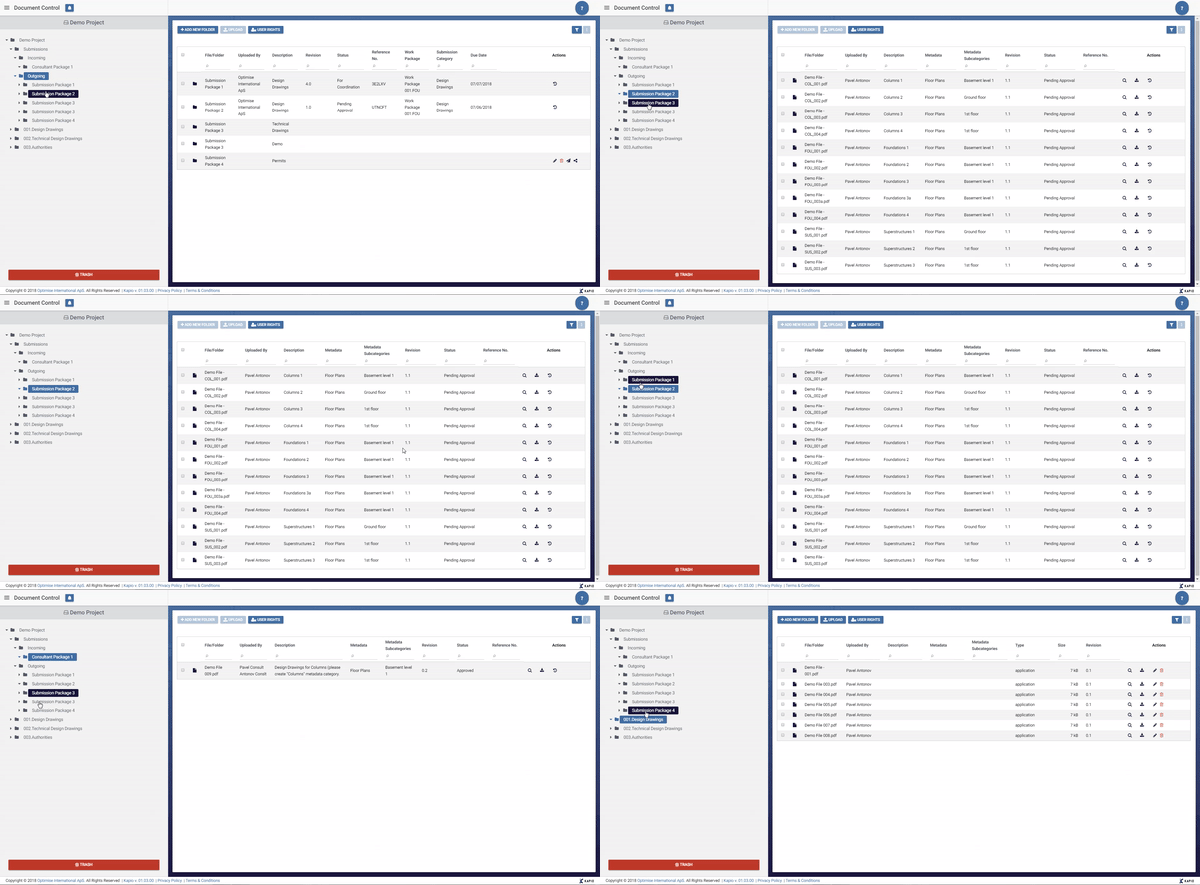
Kapio combines all the features you need to digitize your E&C-projects, including: - Bespoke reports - Real time data reporting - Document control system - Customizable graphical dashboards - Multilingual interface - Secure, double encryption technology.

Apache Spatial Information System (SIS) is a free, open-source Java library designed for developing geospatial applications. It provides data structures for geographic features and associated metadata, along with methods to manipulate these structures. As an implementation of GeoAPI 3.0.2 interfaces, SIS is suitable for both desktop and server applications.
Key Features and Functionality:
- Metadata Handling: Supports the creation of metadata objects compliant with OGC/ISO international standards, facilitating interoperability and data sharing.
- Coordinate Reference Systems (CRS): Enables the construction and transformation of CRS definitions, allowing for accurate geospatial data representation and conversion between different coordinate systems.
- Raster Processing: Offers multi-threaded raster reprojection and isoline computation, enhancing the efficiency of processing large raster datasets.
- Data Format Support: Provides reading and writing capabilities for various geospatial data formats, including GeoTIFF, NetCDF, ESRI formats, and more, ensuring compatibility with diverse data sources.
- Unit Conversion: Implements JSR-385 for parsing, formatting, and converting measurement units, aiding in precise geospatial calculations.
- Geodetic Operations: Supports various map projections such as Mercator, Transverse Mercator, Lambert Conic Conformal, and stereographic, essential for accurate mapping and spatial analysis.
- Geohashes and MGRS: Provides encoding and decoding of geographic coordinates using Geohashes and the Military Grid Reference System (MGRS), facilitating efficient spatial indexing and location referencing.
Primary Value and User Solutions:
Apache SIS addresses the need for a standardized and comprehensive geospatial library in Java, enabling developers to build applications that require precise spatial data handling. By adhering to international standards, it ensures interoperability between different geospatial systems and datasets. Its modular architecture allows users to integrate specific functionalities as needed, making it a versatile tool for tasks ranging from metadata management to complex geodetic computations. This empowers organizations to effectively manage, analyze, and visualize geospatial information, supporting decision-making processes across various domains.


Cloud-based software suite that includes safety inductions, document and project management for main contractors and subcontractors.
About us:
We are authorized CS-Cart partner and provide services for development from scratch and grow online business. Our turnkey solutions help efficiently invest into creating online stores and marketplaces.
About our services:
COMPLEX SOLUTIONS
We provide a complex approach: pre-project analysis, design, development, testing and release a final product. Suitable if you need a comprehensive way.
Marketplace Development on CS-Cart
Ecommerce Project Development
Online Store Development
DEVELOPMENT AND OPTIMIZATION
We provide a full range of development services and automate business process. Suitable if it’s time to scale your project.
Functionality Development for Online Stores
CS-Cart Upgrade
Migration to CS-Cart
Integration for Stores and Marketplaces
Speed and Performance Optimization
Dedicated Development Team
AUDIT AND PROMOTION
We will find out what bottlenecks of speed, help you to increase website conversion and improve usability.
Comprehensive Online Store SEO Audit
Technical SEO Audit
Usability Audit
SEO Promotion
DESIGN DEVELOPMENT
We will develop a convenient and memorable store for your customers. Suitable for new websites and already working.
Online Store Redesign
UI/UX Design Development
Analytics and Architecture Design
TECHNICAL SUPPORT
We are always in touch for stable work of your store and your certainty. We’ll answer any question and help you to set up CS-Cart features.
Technical Support for Online Stores
We work with clients from all around the world. Thanks to the experience gained, we’ve customized 5,000 projects and now can offer 140+ turnkey solutions.

ArcProjects.io is a project collaboration and workflow management platform designed to help teams manage projects, tasks, communication, documentation, and operational workflows from a centralized workspace.
The platform enables organizations to improve project visibility, streamline collaboration, manage timelines, organize files, track progress, and coordinate teams more efficiently across the entire project lifecycle.
ArcProjects.io includes features for project management, task tracking, workflow coordination, file and document management, team collaboration, scheduling, reporting dashboards, and operational oversight. The platform is built to support growing teams that require organized project execution, centralized communication, and scalable workflow management.
ArcProjects.io is suitable for businesses looking to simplify project coordination, improve team productivity, and maintain better operational control across projects and daily activities.

Milliarum GmbH & Co. KG, established in 2006 and headquartered in Mönchengladbach, Germany, specializes in delivering integrated SAP project management solutions. The company focuses on creating innovative and user-centric solutions that are both simple and sustainable, aiming to provide long-term value to their clients.
Key Features and Functionality:
- SAP Project System: Expertise in implementing and optimizing SAP's Project System module to enhance project planning and execution.
- Product Creation Processes: Development of tailored solutions for product creation processes within the SAP environment.
- SAP cProjects and xRPM: Specialization in SAP cProjects and xRPM for comprehensive project and portfolio management.
- Resource and Capacity Management: Provision of tools and methodologies for effective resource allocation and capacity planning.
- Milliarum Cockpit: A proprietary solution based on SAP for streamlined project oversight.
- SAP Fast Track Solutions : Implementation of rapid deployment solutions to accelerate SAP project timelines.
- SAP Web Dynpro ABAP: Development of user-friendly interfaces using SAP's Web Dynpro ABAP technology.
- SAP PPM Enhancements: Customization and enhancement of SAP's Portfolio and Project Management functionalities.
Primary Value and User Solutions:
Milliarum's integrated SAP solutions address the complexities of project and portfolio management by offering streamlined, efficient, and user-friendly tools. By focusing on innovation and user-centric design, they help organizations optimize their project workflows, improve resource allocation, and achieve sustainable project success. Their expertise in SAP technologies ensures that clients receive solutions tailored to their specific needs, enhancing overall operational efficiency.
Silent migration approach to Microsoft Dynamics 365 BC saves up to 47% user and IT team time. Moreover:
SPEED UP THE PRE-PROJECT ANALYSIS
- Predictable Migration Project: The client will have fewer uncertainties and clarifications due to a more predictable approach to migration.
- Faster Quote Provision: We aim to provide quicker detailed indicative assessments for migration in terms of hours and licenses.
SPEED UP THE PROJECT DELIVERY
- Reduction in Labor for Data Migration: We are committed to decreasing the labor required for data migration processes using our out-of-the box tools
- Extended Support from N.Progression: We recommend this for complex data migration projects, as it provides additional support and resources.

How far is this point from the sea? From the nearest border? Which country, region and district are it in? MapGO answers those in one click, then converts your Shapefile, GeoJSON, KML or GeoPackage into whatever format you need next. No GIS software, no install, it all runs in the browser. Measuring, drawing and bulk CSV lookups come with it. 250+ countries. Start free.
Features:
• Distance to Coastline: Get the exact distance from any point to the nearest sea, measured against high-resolution global shoreline data.
• Distance to Border: Find how far a point sits from the nearest administrative boundary, drawn on the map so you see which border matched.
• Location Hierarchy: Turn any coordinate into its full continent, country, region and district chain in one lookup.
• File Conversion: Convert between Shapefile, GeoJSON, KML, GeoPackage, FlatGeobuf and SQLite, and reproject while you're at it.
• Spatial Measurement: Measure distance, area, radius and compass bearing by clicking on the map, in metric or imperial units.
• Intuitive Workspace: Draw, layer, style and edit your own map data in a clean workspace that needs no download or setup.

Furhat Robotics is a Swedish company specializing in social robotics and conversational AI. Their flagship product, the Furhat Robot, is a humanoid social robot designed to facilitate natural face-to-face interactions between humans and machines. By combining advanced speech recognition, facial animation, and customizable personas, Furhat aims to revolutionize human-robot interaction across various sectors, including education, healthcare, and customer service.
Key Features and Functionality:
- Customizable Appearance: Furhat's back-projected 3D face engine allows for the creation of diverse characters with varying ages, ethnicities, and genders, enhancing user engagement.
- Multimodal Interaction: Equipped with a 120° field-of-view camera and stereo microphones, Furhat can track multiple individuals simultaneously, interpret facial expressions, and engage in real-time conversations.
- Expressive Communication: The robot's facial animations and head movements enable it to display a wide range of emotions and gestures, making interactions more lifelike.
- Multilingual Capabilities: Supporting speech recognition and synthesis in over 30 languages, Furhat can communicate effectively with a global audience.
- Developer-Friendly Platform: Furhat offers a comprehensive SDK and development tools, allowing for the creation, debugging, and deployment of custom applications tailored to specific use cases.
Primary Value and Solutions:
Furhat Robotics addresses the need for more natural and engaging human-machine interactions. By providing a platform that mimics human conversational behaviors, Furhat enhances user experiences in various applications:
- Healthcare: Furhat can assist in patient registration, record medical histories, and measure vital signs, alleviating healthcare providers from routine tasks and improving patient care.
- Retail: In retail environments, Furhat serves as a customer service assistant, greeting visitors, accessing online orders, and collecting customer feedback, thereby enhancing the shopping experience.
- Education and Research: Furhat provides a versatile platform for researchers and educators to explore human-robot interaction, develop conversational AI applications, and advance social robotics studies.
By bridging the gap between humans and machines, Furhat Robotics is paving the way for a future where social robots play a pivotal role in various aspects of daily life.
STREAM is a native Windows desktop application for visualizing, measuring and analyzing drone-mapping and GIS terrain data. It loads large DEMs/DSMs, orthophotos, CAD drawings (DXF) and point clouds (LAS/LAZ) and renders them in a smooth, GPU-accelerated 3D environment with adaptive streaming — multi-gigabyte datasets stay fluid and interactive at full resolution, with no downsampling.
Data import & layers
Import GeoTIFF elevation and orthophoto rasters, DXF vector drawings and LAS/LAZ point clouds (rasterized on import to ground DEM, surface DEM or orthophoto). Stack multiple DEMs and orthophotos in a single project with per-layer visibility, opacity and priority. Coordinate system (CRS) handling with on-the-fly reprojection, and fast native caching so projects reopen instantly.
Measurement & drawing
Points, 3D polylines with elevation profiles, area polygons, distance/height/area measurements — all draped precisely on the terrain with snapping, editable coordinates and animated, easy-to-read labels.
Terrain analysis
Slope, aspect, viewshed and line-of-sight analyses, contour generation, and hydrology tools (flow paths, watersheds) — computed at full resolution and displayed as live overlays on the 3D terrain.
Volumes & earthworks
Cut/fill volume computation against multiple reference surfaces, stockpile management with a material library and print-ready PDF reports, and cross-section based volume tables exported to CSV/Excel and DXF.
Terrain editing & scenarios
Flatten, patch and re-triangulate terrain areas non-destructively — edits live in the project and can be exported baked into GeoTIFF. Keep multiple terrain scenarios (before/after, design alternatives) in one project and switch between them instantly.
Export & reporting
DXF (including TIN surfaces), point CSV, area-cropped GeoTIFF, contour DXF, and professional PDF map sheets and reports.
STREAM is built for surveyors, mining and construction teams, and drone-mapping professionals who need CAD/GIS-grade measurement, analysis and reporting in one fast, focused tool. The interface is fully translated into 7 languages and supports both metric and imperial units.