Best GIS Software - Page 27

How Many GIS Software Products Does G2 Track?

Total Products under this Category: 417

Category Stats (Sep 2026)

  • Average Rating: 4.29/5 The average rating of products in this category, based on all submitted ratings
  • Top Trending Product: Smappen (+9.51%) - Among all products in this category, Smappen recorded the largest rating increase compared to last month

Last updated: September 01, 2026

How Does G2 Rank GIS Software Products?

Why You Can Trust G2's Software Rankings:

  • 30 Analysts and Data Experts
  • 8,100+ Authentic Reviews
  • 417+ Products
  • Unbiased Rankings

G2's software rankings are built on verified user reviews, rigorous moderation, and a consistent research methodology maintained by a team of analysts and data experts. Each product is measured using the same transparent criteria, with no paid placement or vendor influence. While reviews reflect real user experiences, which can be subjective, they offer valuable insight into how software performs in the hands of professionals. Together, these inputs power the G2 Score, a standardized way to compare tools within every category.

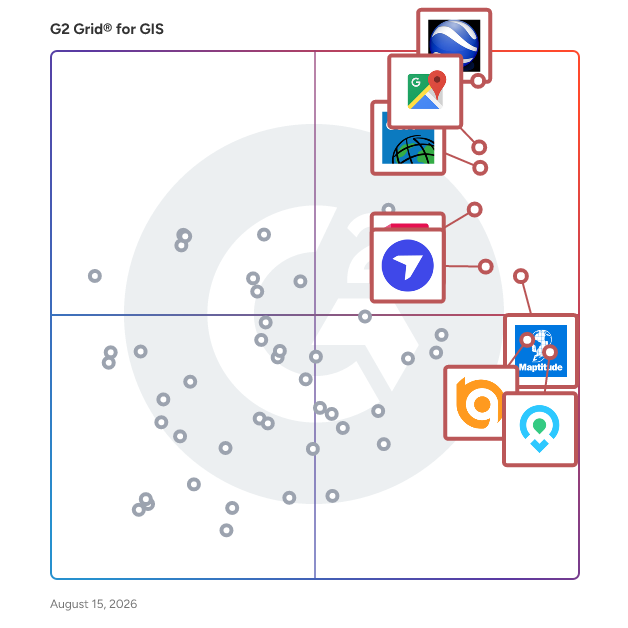
G2 Grid® for GIS Software

G2 Grid® for GIS Software plotting products by satisfaction and market presence

Highlighted products: Google Earth Pro, Google Maps Platform, Esri ArcGIS, AutoCAD, Maptitude, DroneDeploy, Mapme, and BatchGeo.

Underlying data: [Grid® JSON](https://www.g2.com/categories/gis/grids.json?focus%5B%5D=google-earth-pro&focus%5B%5D=google-maps-platform&focus%5B%5D=esri-arcgis&focus%5B%5D=autocad&focus%5B%5D=maptitude&focus%5B%5D=dronedeploy&focus%5B%5D=mapme&focus%5B%5D=batchgeo)

TargomoLOOP

TargomoLOOP is a location optimization tool that assists brick-and-mortar businesses such as shops, restaurants, and service providers in strategic location planning and decision-making. TargomoLOOP is a centralized platform for managing all of your business's location-based information, including customer demographics, retail sales, and service area offerings. Insights gained from this method can be used to examine and enhance retail and hospitality locations, as well as to plot development and optimize the network. Analytics powered by AI can accurately predict sales with an accuracy of 80-90%, as well as find the success drivers of firms and growth possibilities.

Average Rating: 4.0/5.0

Total Reviews: 1

How Do G2 Users Rate TargomoLOOP?

  • Ease of Use: 8.3/10 (Category avg: 8.4/10)

Who Is the Company Behind TargomoLOOP?

  • Seller: Targomo
  • Year Founded: 2013
  • HQ Location: Berlin, DE
  • Twitter: @targomo
    1,212 Twitter followers
  • LinkedIn® Page: www.linkedin.com
    22 employees on LinkedIn®

Who Uses This Product?

  • Company Size: 100% Small

What Do G2 Reviewers Say About TargomoLOOP?

AI-generated summary from verified user reviews

Pros
  • Users value the effective heat map generation of TargomoLOOP for identifying optimal store locations.
  • Users find TargomoLOOP's map creation capabilities invaluable for identifying strategic locations for new store openings.
  • Users value TargomoLOOP for its powerful tools that effectively create heat maps for strategic store placements.

What Are Recent G2 Reviews of TargomoLOOP?

Tasmap

Tasmap is a tool that lets you create personalized maps for travel planning, local guides, favorite spots, and more. You can customize colors, icons, and markers while linking maps with stories to create an interactive experience. No design experience? AI can help generate styles and auto-mark locations, saving you time and effort. Your maps can be added to the home screen for quick access, just like an app, and easily shared with others. With no ads and a focus on privacy, Tasmap provides a clean space for you to design and share your own maps and stories.

Who Is the Company Behind Tasmap?

Tenchijin

Tenchijin is a space tech company that uses satellite data for land evaluation, helping businesses to make informed decisions.

Who Is the Company Behind Tenchijin?

  • Seller: Tenchijin
  • Year Founded: 2019
  • HQ Location: Minato-city, JP
  • LinkedIn® Page: www.linkedin.com
    35 employees on LinkedIn®

TerraExplorer

TerraExplorer is a 3D GIS viewer and creator that fuses terrain, feature layers, raster layers, 3D urban models, point clouds, and 2D/3D objects into a single high-resolution 3D environment for viewing, querying, analysis, and presentation. Powerful measurement, terrain analysis, line of sight, change detection, and spatial analysis tools make it possible to extract operational intelligence from geospatial data. Realistic 3D visualizations are created by overlaying terrain with unlimited data layers, 3D models, and virtual objects. TerraExplorer is available across a full family of deployment options: - TerraExplorer for Desktop — full-featured 3D GIS desktop viewer and creator - TerraExplorer Fusion — web-based 3D geospatial viewer requiring no download or installation, with web applications tailorable to specific customer needs - TerraExplorer Mobile — native mobile app with advanced layer viewing and editing, selected measurement and analysis tools, plus presentation and publishing options - TerraExplorer Mixed Reality — immersive AR/VR 3D geospatial exploration TerraExplorer integrates with PhotoMesh for viewing and inspecting 3D models alongside the source photos used to produce them, and with SkylineGlobe Server for secure streaming of 2D and 3D geospatial content. Used across defense and intelligence, city planning, mapping and surveying, AEC, emergency response, and infrastructure inspection.

Who Is the Company Behind TerraExplorer?

Who Uses This Product?

  • Company Size: 100% Small

What Are Recent G2 Reviews of TerraExplorer?

Ticon

Ticon is a recognized leader in location intelligence and vehicular traffic analysis. Our solutions produce hi-res data with unmatched precision and proven accuracy that give businesses actionable data-driven insights needed to make optimal strategic decisions. Ticon's solutions for site selection, network optimization and operations analytics for retail are available through both subscription-free reports and a platform. Whether you're expanding or optimizing, Ticon helps identify prime locations and enhances operational efficiency for increased profitability.

Who Is the Company Behind Ticon?

  • Seller: Ticon
  • Year Founded: 2016
  • HQ Location: Lewes, US
  • LinkedIn® Page: www.linkedin.com
    9 employees on LinkedIn®

Tile Server Setup

Tile Server Setup is a native Windows desktop application for hosting raster maps as a local XYZ tile service. It is designed for GIS professionals, developers, researchers, and anyone who needs to quickly publish map tiles from their own computer without relying on external cloud services. The application includes an integrated interactive preview, allowing you to verify your map immediately after starting the server. Large datasets can be served efficiently using the bundled GDAL environment, while the built-in HTTPS support enables encrypted local connections. Key Features Serve local raster datasets as an XYZ tile server Integrated live map preview Automatic server start and stop Native C++ application with high performance Bundled WebView2-based preview Integrated GDAL tools for raster processing Local HTTPS support using native Windows Schannel Supports localhost and local network access Simple, modern user interface No cloud services required Works completely offline Ideal for GIS workflows, development, and testing Whether you are testing web mapping applications, preparing GIS projects, or sharing map tiles across your local network, Tile Server Setup provides a lightweight and efficient solution that runs entirely on your own computer while keeping your data under your control.

Who Is the Company Behind Tile Server Setup?

  • Seller: Microsoft
  • Year Founded: 1975
  • HQ Location: Redmond, Washington
  • Twitter: @microsoft
    13,091,739 Twitter followers
  • LinkedIn® Page: www.linkedin.com
    232,750 employees on LinkedIn®
  • Ownership: MSFT

tMap

tMap is a GIS software that is is an easy to use measuring application, with an advanced functionality. The program has been designed for the Android operating system and can be used on tablets, smartphones and other mobile devices (handheld).

Who Is the Company Behind tMap?

  • Seller: Taxus IT
  • Year Founded: 2013
  • HQ Location: Warszawa, PL
  • LinkedIn® Page: www.linkedin.com
    22 employees on LinkedIn®

TNTmips

TNTmips software is a complete Geographic Information System (GIS) that lets you work with virtually any type of geospatial data including imagery, terrain surfaces, and map data with associated database attributes.

Who Is the Company Behind TNTmips?

Touch GIS

Touch GIS takes full advantage of the device you already have in your pocket, making field data collection easier than ever. Save thousands while enjoying best-in-class features.

Who Is the Company Behind Touch GIS?

TRAISR

Who Is the Company Behind TRAISR?

  • Seller: TRAISR
  • HQ Location: Plymouth Meeting, US
  • LinkedIn® Page: www.linkedin.com
    11 employees on LinkedIn®

Treweler

Treweler is a WordPress mapping plugin that enables users to create and manage interactive maps using the Mapbox platform. It is designed for developers, businesses, and individuals who need to visualize, organize, and present location-based data within WordPress websites. The plugin supports multiple geographic data types, including markers, routes, polygons, shapes, and 3D models, allowing structured representation of spatial information. It can be applied to various use cases such as store locators, travel maps, real estate listings, interactive tours, and other map-based interfaces where geographic data needs to be displayed and explored. Treweler provides control over map configuration, including styles, layers, and user interactions. Data can be imported from external sources such as Google Sheets, GeoJSON, and GPX, and can also be managed directly through the WordPress admin panel. This enables both static and dynamic map setups without requiring a separate system. Key features and capabilities include: - Support for multiple data formats, including markers, routes, polygons, GeoJSON, GPX, and 3D objects - Map configuration through styling options, layers, and interactive behaviors - Filtering, categorization, and clustering for organizing and displaying map data - Geolocation and coordinate-based interaction with map elements - Data import and management via Google Sheets and the WordPress admin interface The plugin is designed to handle large datasets and includes features that support efficient rendering and interaction with map elements. It can be integrated into most WordPress themes and page builders, allowing maps to be added to existing websites without additional infrastructure. Treweler can be used as part of content-driven websites or as a component within more complex web applications that require geographic data visualization.

Who Is the Company Behind Treweler?

UpGrid

Who Is the Company Behind UpGrid?

  • Seller: Placematic
  • Year Founded: 2016
  • HQ Location: Rolling Meadows, US
  • LinkedIn® Page: www.linkedin.com
    4 employees on LinkedIn®
Daniel Rivera
DR
Researched and written by Daniel Rivera
Updated March 4, 2025