LUCIAD
Who Is the Company Behind LUCIAD?
- Seller: LUCIAD
- HQ Location: Norcross, US
-
LinkedIn® Page: www.linkedin.com
51 employees on LinkedIn®
Total Products under this Category: 414
Last updated: September 01, 2026
Why You Can Trust G2's Software Rankings:
G2's software rankings are built on verified user reviews, rigorous moderation, and a consistent research methodology maintained by a team of analysts and data experts. Each product is measured using the same transparent criteria, with no paid placement or vendor influence. While reviews reflect real user experiences, which can be subjective, they offer valuable insight into how software performs in the hands of professionals. Together, these inputs power the G2 Score, a standardized way to compare tools within every category.
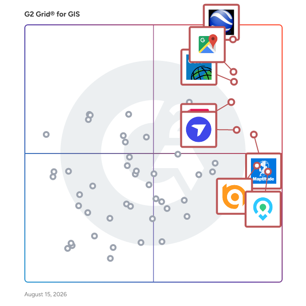
Highlighted products: Google Earth Pro, Google Maps Platform, Esri ArcGIS, AutoCAD, Maptitude, DroneDeploy, Mapme, and BatchGeo.
Underlying data: [Grid® JSON](https://www.g2.com/categories/gis/grids.json?focus%5B%5D=google-earth-pro&focus%5B%5D=google-maps-platform&focus%5B%5D=esri-arcgis&focus%5B%5D=autocad&focus%5B%5D=maptitude&focus%5B%5D=dronedeploy&focus%5B%5D=mapme&focus%5B%5D=batchgeo)
Build an amazing map experience that makes your application stand out from the crowd. Display a map with the required level of detail – fresh and reliable on a global scale. Customize the look and feel to fit your business and customer.
Map Editor is an application that delivers fast and intuitive real-time collaboration on a map using any device.
Integrate Maps, CAD & Sensors to your Field Inspections & Maintenance Operations
MAPOG is an AI-powered mapping platform that transforms your locations, projects, portfolios, and data into interactive visual maps. Instead of scattered files or reports, users can import data from CSV or Excel and display every site on a single map — complete with photos, videos, links, and key details for each point. Add custom base maps using geo-referencing to showcase campuses, layouts, or property overviews, and use bearing angle measurement for navigation, planning, or surveying. Collect and update field data through Mobile Data Collection, assign and track tasks with Task Management, and sort nearby sites by live location for faster visits and maintenance. Organize maps with layers and filters, analyze nearby places, and export offline for reports or presentations. Share securely with your team using role-based access or public/private links, making MAPOG the all-in-one mapping solution for real estate, travel, education, logistics, and more.
Average Rating: 4.5/5.0
Total Reviews: 1
"Easy Access to GIS Data for Spatial Analysis"
Rating: 4.5/5.0 stars
— Natalia .
MapRite is a automated software solution for asset location alignment and correction. It delivers data cleansing, auditing, conflation and the management of real-world change to unprecedented levels of accuracy.
Mapthrust is proud to offer highly powerful mapping APIs that rival those of Google Maps APIs, all with a fraction of the price. Additionally, Mapthrust makes it a breeze to migrate from Google Maps. It just takes a line of code change to join us.
Interactive Digital Maps to improve the customer user experience, analyze data and monetize traffic within physical spaces such as Shopping Centers, Airports, Resorts or Universities. The intelligent mapping platform that combines seamless navigation with marketing automation, real-time analytics, and AI assistance – helping venues drive sales and optimize operations.
Mapzania is a powerful, flexible and simple to implement geospatial software library that allows Microsoft .Net application developers to take advantage of the growing market for location-based software and data solutions.
"Amazed with the capabilities of the product"
Rating: 5.0/5.0 stars
— Philip N.
"Drop in mapping framework for your application"
Rating: 5.0/5.0 stars
— Verified User in Computer Software
