Habyl
Who Is the Company Behind Habyl?
- Seller: TechProg
- Year Founded: 2013
- HQ Location: SANILHAC, FR
-
LinkedIn® Page: www.linkedin.com
1 employees on LinkedIn®
Total Products under this Category: 212
Last updated: November 02, 2026
Why You Can Trust G2's Software Rankings:
G2's software rankings are built on verified user reviews, rigorous moderation, and a consistent research methodology maintained by a team of analysts and data experts. Each product is measured using the same transparent criteria, with no paid placement or vendor influence. While reviews reflect real user experiences, which can be subjective, they offer valuable insight into how software performs in the hands of professionals. Together, these inputs power the G2 Score, a standardized way to compare tools within every category.
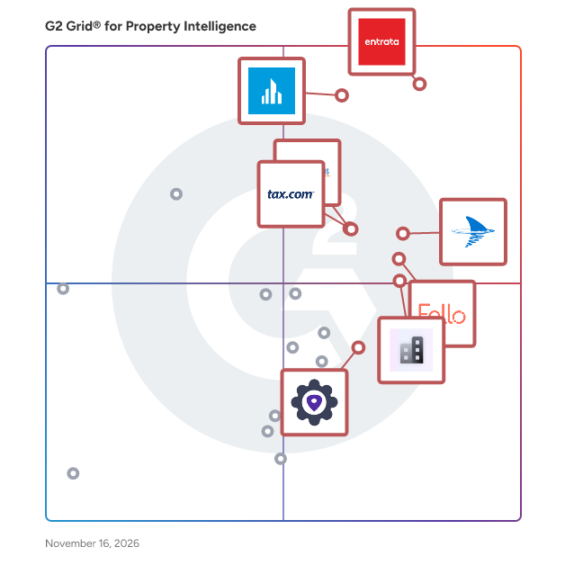
Highlighted products: Entrata, Crexi, PropertyShark, Fello, tax.com, Market Surveys, BatchLeads, and Real Estate API.
Underlying data: [Grid® JSON](https://www.g2.com/categories/property-intelligence/grids.json?focus%5B%5D=entrata&focus%5B%5D=crexi&focus%5B%5D=propertyshark&focus%5B%5D=fello-fello&focus%5B%5D=tax-com-tax-com&focus%5B%5D=market-surveys&focus%5B%5D=batchleads&focus%5B%5D=real-estate-api)
Harper AI is a B2B SaaS platform that transforms public UK property finance data into actionable intelligence. We ingest data from Companies House charges, Land Registry records, and corporate structures covering hundreds of thousands of companies and millions of loan records. For brokers: originate deals before the phone rings with lead generation, charge tracking, and refinancing signals. For lenders: defend market position, monitor competition, and identify borrowers who may need new finance. For debt advisories: track distressed assets, insolvencies, and conduct due diligence on officers. Key features include company and officer search, lender intelligence with market share analysis, charge tracking with map-based filtering, automated lead lists with contact enrichment, trigger notifications, competition tracking, and an AI-powered chatbot for querying data.
HomeOn is an innovative Australian platform that leverages artificial intelligence to provide independent home value estimates and comprehensive data insights for nearly one million homes across the Greater Sydney region. Unlike traditional property estimators, HomeOn allows users to collaborate with its AI-powered calculator, enhancing valuation accuracy by incorporating user-provided property details. This interactive approach ensures more precise and personalized home valuations. Key Features and Functionality: - AI-Enabled Home Value Calculator: Users can input specific property information to refine and improve the accuracy of home value estimates. - Comprehensive Data Insights: Access detailed information on individual properties, including sales history, supply and demand patterns, and historical value changes in the surrounding area. - User-Friendly Interface: The platform offers an intuitive design, making it easy for users to navigate and utilize its features without requiring personal information or registration. Primary Value and User Solutions: HomeOn addresses the common challenges faced by Australian home buyers and sellers by providing accurate, up-to-date property valuations and insights. By combining AI technology with user input, it empowers users to make informed decisions, reducing the risk of costly mistakes in the real estate market. This collaborative approach ensures that every home valuation reflects both data-driven analysis and individual property nuances.
Connect G2 to Claude or ChatGPT for answers grounded in G2's trusted reviews, comparisons, and pricing from real user insights.
HomesIndex is a property search platform for England and Wales that compares asking prices to sold prices using HM Land Registry data. It aggregates estate agent listings and scores properties against local sold records to identify those below market value. Users can search by area, neighborhood, postal sector, or postcode, with an option to draw custom boundaries on an interactive map. Filters refine results by property type, bedrooms, bathrooms, ownership type, and buying schemes like shared ownership. Additional filters include transport links, schools, crime rates, flood risks, and features like en-suites, open-plan kitchens, fireplaces, solar panels, and EV chargers. Sorting options rank properties by value, price per square foot, total price, or listing date. Analytical tools offer graphs, comparable data, and cost calculations, helping users assess local market conditions and property valuations based on verified sales records.
Need fast access to local property market analysis and trends? Make more informed business and investment decisions with Hometrack’s reports and online services.
HouseCanary for Agents is HouseCanary's platform for licensed real estate agents. Agents verify with their state license (no NAR membership required) and get CMA reports, property search and valuations, propensity-to-list lookups, market insights and CanaryAI, HouseCanary's AI assistant. The Pro plan includes unlimited CMAs and two team seats. Valuations come from HouseCanary's automated valuation model, which covers 136M+ U.S. properties. As of October 1, 2026, its median error is 2.7% on listed homes and 7.5% before a home is listed. Ads Manager, now in early access, lets agents run Google Local Services Ads that charge only when a buyer or seller makes contact.
ID Plans is a leading provider of integrated solutions for the commercial real estate (CRE) industry. Headquartered in Tampa, FL, we specialize in delivering cutting-edge technology that centralizes property, asset, and tenant data into one unified platform. Founded in 1999, we’ve grown to become a trusted partner for property management teams, asset managers, and operations directors across the United States and beyond. With a focus on operational efficiency and innovation, ID Plans helps real estate teams optimize their portfolios through smarter, data-driven decision-making. Key Features and Functionality ID Cloud is an all-in-one platform designed to streamline commercial real estate operations. Key features include: Centralized Data Management: Consolidate property, tenant, and asset information into one platform, enabling seamless collaboration across teams. Real-Time Data Analytics & Visualization: Gain actionable insights with interactive dashboards and data visualization tools to improve decision-making. Tenant Engagement: Simplify tenant communication and management with dedicated portals for easy access to property information, requests, and updates. Proactive Maintenance & Inspections: Track and schedule maintenance, inspections, and asset management to keep properties in optimal condition. Cloud Integration: As a cloud-based solution, ID Cloud ensures data accessibility anytime, anywhere, without the need for expensive IT infrastructure. Primary Value and Problem Solved ID Cloud solves the fragmented nature of traditional property management by providing a centralized, cloud-based platform that streamlines operations, enhances data accessibility, and improves tenant relationships. By integrating data and automation, ID Cloud reduces inefficiencies, minimizes manual errors, and enables faster decision-making, ultimately improving ROI. Whether you’re managing a few properties or a large portfolio, ID Cloud empowers CRE teams to work smarter, reduce operational costs, and improve tenant satisfaction through a unified, scalable solution.
Market Intelligence Suite helps to create data-driven marketing presentations and CMA reports incorporating such data points as median sales prices and market trends.
Property data API for developers and enterprise teams. Nine primitives: Permits, AVM, Condition Score, System Lifecycle, Contractor History, Market Intelligence, Investment Outlook, ARVE, and Property Records joined in a single call on any U.S. address. 5,600+ permit sources, 8-day median data lag, real-time permit labeling. Used by insurers, mortgage platforms, and proptech teams for underwriting, origination, and renovation intelligence.
Landchecker brings all your Australian property information into one place. Property information is fragmented across different States, Councils and Private businesses. This takes time to source relevant data across all these various websites. The Landchecker Platform standardises, nationalises and centralises property information on an easy to use Map Interface. Get Fast, Accurate and Easy to use property information to make the right decisions all in one place. Data available includes Land Size, Sales History, Zones/Layers, Overlays, Permits and DA Status, Digitised Easements, Flood, Bushfire, Heritage and current as well as Historical High Resolution Aerial Imagery to name a few that can easily seen on the map or generated in a 1 click PDF Report to share with your team or customers. Save money by purchasing key property documents such as Titles, Copy of Plan and Certificates and more.
Landholder Connect is land access and stakeholder management software for lean teams: junior explorers, renewable developers, consultancies and any project without a dedicated land access department. It starts from the title. Drop in a title search and get the property with its owners already linked. Record every call, meeting and site visit against the people and the land. Track each obligation from an access agreement until it is met, and see what is overdue or coming up across the project. It keeps the records a regulator or a dispute will ask for: the engagement register, a complaints log with response times, matters with every stage dated, and a change history of every save. Restricted records keep confidential dealings to Directors. It works across Australia. Parcel boundaries come from the states’ own registers, and current tenements over a property are read from six states’ services. A live map layer brings your parcels into QGIS or ArcGIS Pro, and it works alongside your existing tenement system. Optional AI features summarise a stakeholder’s history, draft correspondence and pick out what is being raised across a project. They run in Australia, and nothing is saved to your records until a person accepts it. One plan: A$499 a month plus GST for three projects, A$149 for each extra project, with unlimited users. No implementation project, and a 14-day free trial. Australian-owned and independent.
Latapult is a premier Geographic Information System (GIS) platform that powers data-validated, location-smart business decisions with collaborative, dynamic mapping. Backed by GIS experts with roots in geospatial data analysis, Latapult is a trusted partner, helping professionals across industries complete successful projects through collaborative tools and deep insights.
