Best Photogrammetry Software - Page 2

How Many Photogrammetry Software Products Does G2 Track?

Total Products under this Category: 52

Category Stats (Sep 2026)

  • Average Rating: 4.48/5 The average rating of products in this category, based on all submitted ratings

Last updated: September 24, 2026

How Does G2 Rank Photogrammetry Software Products?

Why You Can Trust G2's Software Rankings:

  • 30 Analysts and Data Experts
  • 100+ Authentic Reviews
  • 52+ Products
  • Unbiased Rankings

G2's software rankings are built on verified user reviews, rigorous moderation, and a consistent research methodology maintained by a team of analysts and data experts. Each product is measured using the same transparent criteria, with no paid placement or vendor influence. While reviews reflect real user experiences, which can be subjective, they offer valuable insight into how software performs in the hands of professionals. Together, these inputs power the G2 Score, a standardized way to compare tools within every category.

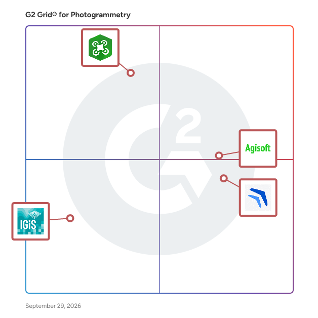
G2 Grid® for Photogrammetry Software

G2 Grid® for Photogrammetry Software plotting products by satisfaction and market presence

Highlighted products: ArcGIS Drone2Map, Agisoft PhotoScan, Mapware, and IGiS Photogrammetry Suite.

Underlying data: [Grid® JSON](https://www.g2.com/categories/photogrammetry/grids.json?focus%5B%5D=arcgis-drone2map&focus%5B%5D=agisoft-photoscan&focus%5B%5D=mapware&focus%5B%5D=igis-photogrammetry-suite)

Avica Cloud

Avica is a cloud-based 3D reconstruction platform launched by Rayvision. Based on the rapid scheduling of massive machines and Bentley Contextcapture technology, Avica provides quality performance and effective cloud services for 3D reconstruction of real scenes, greatly saving customers' time and budget.

Average Rating: 4.3/5.0

Total Reviews: 2

Who Is the Company Behind Avica Cloud?

Who Uses This Product?

  • Company Size: 100% Small, 50% Medium

What Are Recent G2 Reviews of Avica Cloud?

MetaShape

Metashape products can be smoothly transferred to external tools thanks to a variety of export formats.

Average Rating: 4.5/5.0

Total Reviews: 2

Who Is the Company Behind MetaShape?

Who Uses This Product?

  • Company Size: 33% Large, 33% Medium

What Are Recent G2 Reviews of MetaShape?

What Are G2 Users Discussing About MetaShape?

Octave Imagine Photogrammetry (IMAGINE Photogrammetry)

IMAGINE Photogrammetry maximizes productivity with state-of-the-art photogrammetric satellite and aerial image processing algorithms.

Average Rating: 3.5/5.0

Total Reviews: 2

Who Is the Company Behind Octave Imagine Photogrammetry (IMAGINE Photogrammetry)?

Who Uses This Product?

  • Company Size: 100% Small

Pixpro Software

Pixpro is a photogrammetry software application that processes drone or camera images into accurate 3D models, with built-in tools for precise measurement, surface modeling, and analysis. Built by photogrammetry experts since 2014 and powered by a patented image-processing algorithm, Pixpro serves solar designers, drone pilots, architects, surveyors, and dozens of other professionals who need accurate results without a steep learning curve. Beyond standard 3D reconstruction, Pixpro includes flight planning through Waypoints, DEM editing, on-model annotation, and line-of-sight and obstruction analysis, a feature set that goes well beyond typical photogrammetry software. The result is a complete workflow, from flight to finished measurement, backed by direct, expert-level support every step of the way.

Average Rating: 4.8/5.0

Total Reviews: 2

Who Is the Company Behind Pixpro Software?

Who Uses This Product?

  • Company Size: 150% Large, 50% Small

What Are Recent G2 Reviews of Pixpro Software?

Constra Survey

Constra Survey is an advanced visual intelligence platform designed to revolutionize pre-construction land surveying. By integrating drone technology with AI-powered software, it delivers detailed and accurate topographical and cadastral surveys within 24 hours. This modern approach replaces traditional, time-consuming methods, offering construction professionals precise data to enhance project planning and execution. Key Features and Functionality: - High-Resolution Aerial Imaging: Utilizes drones to capture comprehensive site images, ensuring thorough data collection. - AI-Powered Data Processing: Employs computer vision algorithms to generate detailed 3D models and maps from aerial data. - Contour Mapping: Visualizes land surface and shape, aiding architects in accurate construction planning. - Streamflow Simulation: Simulates rainwater flow and potential flooding, assisting in drainage and rainwater harvesting system design. - Remote Monitoring: Enables stakeholders to oversee site conditions and progress without physical presence. Primary Value and User Solutions: Constra Survey addresses the inefficiencies of traditional land surveying by providing rapid, accurate, and cost-effective solutions. It minimizes human error, reduces the need for on-site visits, and delivers comprehensive data that enhances decision-making. By offering real-time insights and detailed visualizations, Constra Survey empowers construction leaders to plan effectively, manage risks, and optimize project outcomes.

Average Rating: 4.5/5.0

Total Reviews: 1

Who Is the Company Behind Constra Survey?

Who Uses This Product?

  • Company Size: 100% Small

What Are Recent G2 Reviews of Constra Survey?

ContextCapture

ContextCapture is Bentley’s reality modeling software that can quickly produce 3D models of existing conditions for infrastructure projects of all types, derived from simple photographs and/or point cloud. Without the need for expensive or specialized equipment, ContextCapture enables users to quickly create and use these highly-detailed 3D engineering-ready reality meshes to provide precise real-world digital context for design, construction, and operations decisions throughout the project lifecycle. Project teams can easily and consistently share reality modeling information, consumable and accessible, on desktop and mobile devices, in various formats, including native use within MicroStation for use in any engineering, operations, maintenance, or GIS workflow.  ContextCapture provides: - High-fidelity 3D engineering-ready reality meshes generated with simple photos and/or point clouds  - Accessibility to every member of a project design, delivery or asset management team to create 3D models from anywhere, in the field or at the office.  It enables an immersive reality modeling experience through any browser, with progressive levels of detail using the Web Ready 3D Scalable Mesh format.   - High-end performance and scalability with multi-engine parallel processing speeds and scalable mesh technology   - Shareability in a connected data environment to stream 3D meshes across project teams and interoperability with other software 

Average Rating: 5.0/5.0

Total Reviews: 1

Who Is the Company Behind ContextCapture?

  • Seller: Bentley Systems
  • Year Founded: 1984
  • HQ Location: Exton, PA
  • Twitter: @BentleySystems
    17,564 Twitter followers
  • LinkedIn® Page: www.linkedin.com
    5,656 employees on LinkedIn®
  • Ownership: NASDAQ: BSY

Who Uses This Product?

  • Company Size: 100% Small

What Are Recent G2 Reviews of ContextCapture?

What Are G2 Users Discussing About ContextCapture?

Get3D Mapper

Get3D Mapper is a Large-scale Photogrammetric 3D Cluster Modeling software for the professional mapping and general-mapping applications.Combining advanced photogrammetry, computer vision, and deep learning technologies, it supports automated aerial triangulation, 3D reconstruction, and multi-source data processing for oblique imagery, aerial photography, close-range photography, and laser point clouds.The software can generate highly accurate, high quality 2D Maps ( DSM / DOM) and 3D Products (standard 3D Model, point cloud products, etc.).

Average Rating: 5.0/5.0

Total Reviews: 1

Who Is the Company Behind Get3D Mapper?

Who Uses This Product?

  • Company Size: 100% Medium

What Are Recent G2 Reviews of Get3D Mapper?

KIRI Engine

KIRI Engine is a photogrammetry 3D scanning app for iOS, Android, and web browsers. Thanks its robust, AI-backed algorithm, KIRI Engine is able to generate excellent, textured 3D scans even with low-quality photos or lighting. A large part of our user community is in CGI and VFX, using 3D scans to create photorealistic effects, scenes, video games, and more. There's a lot of potential for use in augmented and virtual reality! Many other users have been leveraging KIRI Engine to create 3D printable files, as well. A few highlights from KIRI Engine (for all users): - Choice between low, medium, and high-quality exports - AI-based algorithms to limit the impact of lighting changes - Option to use a turntable - Manually select/remove photos from a project - Creator Program: get paid for your scans! Plus, you can export your scans in a variety of formats such as OBJ, FBX, USDZ, GLTF, and more. Our dev team is constantly working on improving the app with new features and formats, based on feedback from our Discord user family.

Average Rating: 4.5/5.0

Total Reviews: 2

Who Is the Company Behind KIRI Engine?

Who Uses This Product?

  • Company Size: 50% Medium, 50% Small

What Are Recent G2 Reviews of KIRI Engine?

LiveFurnish

imagine.io is 3D made simple for furniture, home furnishings, appliances & more. We make it easy for anyone to create stunning photorealistic visual content on demand without any 3D or engineering skills. Save 80% of the time & 90% of the cost compared to studio photography. Seamlessly produce digital prototypes, silos, vignettes, room scenes, videos, VR, 360 spins & product configurators for sales, marketing & eCommerce that boost buyer confidence and sales conversion rates. Design and visualize products in 3D and reduce sampling costs, increase production time and go to market faster, all with imagine.io. Try it free or book a demo with our team to learn more.

Average Rating: 4.5/5.0

Total Reviews: 1

Who Is the Company Behind LiveFurnish?

Who Uses This Product?

  • Company Size: 100% Small

What Are Recent G2 Reviews of LiveFurnish?

Micmac

MicMac is a free open-source (Cecill-B licence) photogrammetric suite that can be used in a variety of 3D reconstruction scenarios. In aims mainly at professionnal or academic users but constant efforts are made to make it more accessible to the general public.

Average Rating: 5.0/5.0

Total Reviews: 1

Who Is the Company Behind Micmac?

Who Uses This Product?

  • Company Size: 100% Medium

What Are Recent G2 Reviews of Micmac?

What Are G2 Users Discussing About Micmac?

OpenReco — Open-source photogrammetry & 3D reconstruction

OpenReco is an open-source photogrammetry and reality-capture platform for generating 3D models, point clouds, textured meshes, and terrain data from photographs. Designed for researchers, surveyors, drone operators, developers, and creators, OpenReco provides image alignment, camera calibration, sparse and dense reconstruction, mesh generation, and texturing in a transparent, extensible alternative to commercial photogrammetry software.

Average Rating: 5.0/5.0

Total Reviews: 1

Who Is the Company Behind OpenReco — Open-source photogrammetry & 3D reconstruction?

  • Seller: GitHub
  • Year Founded: 2008
  • HQ Location: San Francisco, CA
  • Twitter: @github
    2,673,925 Twitter followers
  • LinkedIn® Page: www.linkedin.com
    6,653 employees on LinkedIn®

Who Uses This Product?

  • Company Size: 100% Small

What Are Recent G2 Reviews of OpenReco — Open-source photogrammetry & 3D reconstruction?

Optelos

Optelos is a flexible, scalable and secure cloud-based visual data management and AI analytics platform that transforms geovisual data into actionable insights. Our patented technology geolocates and correlates all types of asset inspection data, organizing vast amounts of unstructured data into an intuitive, contextualized and searchable database ready for analysis and AI implementation. Leveraging computer vision AI, advanced image modeling and APIs for enterprise systems integration, Optelos enables businesses to operationalize and automate their visual asset inspection programs. Optelos is based in Austin, TX.

Average Rating: 4.0/5.0

Total Reviews: 1

Who Is the Company Behind Optelos?

  • Seller: Optelos
  • Year Founded: 2016
  • HQ Location: Deer Park, US
  • Twitter: @optelos
    136 Twitter followers
  • LinkedIn® Page: www.linkedin.com
    22 employees on LinkedIn®

Who Uses This Product?

  • Company Size: 100% Small

What Are Recent G2 Reviews of Optelos?

What Are G2 Users Discussing About Optelos?

Pix4Dmatic

Pix4Dmatic is the next-generation photogrammetry software for large scale and corridor mapping. It is designed to work with the latest drones and tackle bigger projects faster than ever before, crunching over 10,000 images with ease and no need to break them into separate projects.

Average Rating: 4.5/5.0

Total Reviews: 1

Who Is the Company Behind Pix4Dmatic?

  • Seller: Pix4D
  • Year Founded: 2011
  • HQ Location: Prilly, Vaud
  • Twitter: @pix4d
    20,550 Twitter followers
  • LinkedIn® Page: www.linkedin.com
    192 employees on LinkedIn®

Who Uses This Product?

  • Company Size: 100% Small

What Are Recent G2 Reviews of Pix4Dmatic?

Polycam

Polycam is a 3D scanning application that offers a range of capabilities and services designed for both individual creators and businesses. Polycam's services and products are geared towards democratizing 3D content creation and providing tools that enhance productivity and creativity across various sectors. Key features include: [3D Scanning] Create 3D scans of your environment using mobile devices equipped with LiDAR sensors, as well as through photogrammetry techniques using standard photos from any camera. [LiDAR Technology] Fast, accurate scanning for professional use on LiDAR-enabled devices. [Photogrammetry] Create detailed 3D models from photos without LiDAR. [Editing Tools] Edit scans with tools like cropping, rotating, and scaling. [Collaboration] Share 3D models for team projects requiring 3D visualization. [Export & Integration] Export scans in multiple formats for easy integration with other tools, ideal for architecture, engineering, and game development.

Average Rating: 5.0/5.0

Total Reviews: 1

Who Is the Company Behind Polycam?

  • Seller: PolyCam
  • Year Founded: 2020
  • HQ Location: San Francisco, California, United States
  • LinkedIn® Page: www.linkedin.com
    49 employees on LinkedIn®

Who Uses This Product?

  • Company Size: 100% Small

What Are Recent G2 Reviews of Polycam?

Regard3D

Regard3D is a free and open source structure-from-motion program. It converts photos of an object, taken from different angles, into a 3D model of this object.

Average Rating: 4.5/5.0

Total Reviews: 1

Who Is the Company Behind Regard3D?

Who Uses This Product?

  • Company Size: 200% Medium

What Are Recent G2 Reviews of Regard3D?

Daniel Rivera
DR
Researched and written by Daniel Rivera
Updated October 3, 2024