Best GIS Software - Page 9

How Many GIS Software Products Does G2 Track?

Total Products under this Category: 414

Category Stats (Sep 2026)

  • Average Rating: 4.29/5 The average rating of products in this category, based on all submitted ratings
  • Top Trending Product: Smappen (+9.51%) - Among all products in this category, Smappen recorded the largest rating increase compared to last month

Last updated: September 01, 2026

How Does G2 Rank GIS Software Products?

Why You Can Trust G2's Software Rankings:

  • 30 Analysts and Data Experts
  • 8,100+ Authentic Reviews
  • 414+ Products
  • Unbiased Rankings

G2's software rankings are built on verified user reviews, rigorous moderation, and a consistent research methodology maintained by a team of analysts and data experts. Each product is measured using the same transparent criteria, with no paid placement or vendor influence. While reviews reflect real user experiences, which can be subjective, they offer valuable insight into how software performs in the hands of professionals. Together, these inputs power the G2 Score, a standardized way to compare tools within every category.

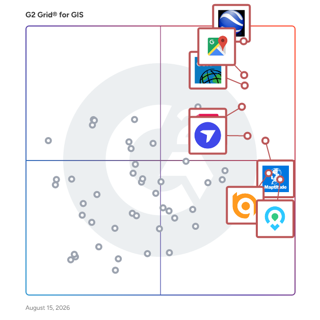
G2 Grid® for GIS Software

G2 Grid® for GIS Software plotting products by satisfaction and market presence

Highlighted products: Google Earth Pro, Google Maps Platform, Esri ArcGIS, AutoCAD, Maptitude, DroneDeploy, Mapme, and BatchGeo.

Underlying data: [Grid® JSON](https://www.g2.com/categories/gis/grids.json?focus%5B%5D=google-earth-pro&focus%5B%5D=google-maps-platform&focus%5B%5D=esri-arcgis&focus%5B%5D=autocad&focus%5B%5D=maptitude&focus%5B%5D=dronedeploy&focus%5B%5D=mapme&focus%5B%5D=batchgeo)

Fuse.Earth

GIS Reimagined, Demystified, and Democratized. Fuse.Earth is the next generation GIS that takes a lot of file processing and traditional technique intensive GIS processes away and puts GIS tools and answers at the fingertips of end users (non-trained GIS experts).

Average Rating: 4.5/5.0

Total Reviews: 2

How Do G2 Users Rate Fuse.Earth?

  • Data Capture: 10.0/10 (Category avg: 8.6/10)
  • Data Visualization: 8.3/10 (Category avg: 8.6/10)
  • Ease of Use: 5.8/10 (Category avg: 8.4/10)
  • Spatial Analysis: 8.3/10 (Category avg: 8.4/10)

Who Is the Company Behind Fuse.Earth?

Who Uses This Product?

  • Company Size: 100% Small

What Are Recent G2 Reviews of Fuse.Earth?

FuturaGIS

FuturaGIS helps expand and grow with your work processes and seamless integration to grow with your business infrastructure.

Average Rating: 2.8/5.0

Total Reviews: 2

How Do G2 Users Rate FuturaGIS?

  • Data Capture: 6.7/10 (Category avg: 8.6/10)
  • Data Visualization: 10.0/10 (Category avg: 8.6/10)
  • Ease of Use: 8.3/10 (Category avg: 8.4/10)
  • Spatial Analysis: 6.7/10 (Category avg: 8.4/10)

Who Is the Company Behind FuturaGIS?

  • Seller: Futura Systems
  • Year Founded: 2008
  • HQ Location: Dunwoody, US
  • Twitter: @FuturaGIS
    455 Twitter followers
  • LinkedIn® Page: www.linkedin.com
    65 employees on LinkedIn®

Who Uses This Product?

  • Company Size: 100% Small

What Are Recent G2 Reviews of FuturaGIS?

What Are G2 Users Discussing About FuturaGIS?

IGiS Desktop (Powered by Scanpoint Geomatics Limited)

IGiS Desktops are next-generation cartographic and visualization tools for conceptualization, production, dissemination, and analysis of 2D and 3D maps. It is a 64-bit, Unicode compliant Desktop GIS with an intuitive user interface where data can be viewed in multiple tabs using Multiple Document Interface (MDI).

Average Rating: 5.0/5.0

Total Reviews: 2

How Do G2 Users Rate IGiS Desktop (Powered by Scanpoint Geomatics Limited)?

  • Data Capture: 10.0/10 (Category avg: 8.6/10)
  • Data Visualization: 9.2/10 (Category avg: 8.6/10)
  • Ease of Use: 10.0/10 (Category avg: 8.4/10)
  • Spatial Analysis: 9.2/10 (Category avg: 8.4/10)

Who Is the Company Behind IGiS Desktop (Powered by Scanpoint Geomatics Limited)?

Who Uses This Product?

  • Company Size: 100% Small

What Are Recent G2 Reviews of IGiS Desktop (Powered by Scanpoint Geomatics Limited)?

ILWIS

Remote Sensing and GIS software

Average Rating: 4.5/5.0

Total Reviews: 2

How Do G2 Users Rate ILWIS?

  • Data Capture: 8.3/10 (Category avg: 8.6/10)
  • Data Visualization: 6.7/10 (Category avg: 8.6/10)
  • Ease of Use: 7.5/10 (Category avg: 8.4/10)
  • Spatial Analysis: 10.0/10 (Category avg: 8.4/10)

Who Is the Company Behind ILWIS?

Who Uses This Product?

  • Company Size: 100% Medium, 100% Small

What Do G2 Reviewers Say About ILWIS?

AI-generated summary from verified user reviews

Pros
  • Users value the comprehensive data integration in ILWIS, enhancing their analysis of geospatial and environmental changes.
  • Users value ILWIS for its effective geospatial analysis tools, facilitating comprehensive integration of diverse data sets.
  • Users appreciate the wide range of tools in ILWIS, enhancing their ability for geographic data processing and analysis.
  • Users appreciate ILWIS for its comprehensive GIS tools, enabling effective geographic data processing and map generation.
  • As an environmental scientist, I find ILWIS offers extensive mapping features that enhance my geospatial data analysis.
Cons
  • Users find the feature limitations of ILWIS frustrating, especially regarding data transfer and menu-based operations.
  • Users face API issues with ILWIS, limiting data sharing and collaboration due to lack of web browser support.
  • Users experience challenges with big data issues, particularly difficulties in transferring and saving data in the cloud.
  • Users experience integration issues with ILWIS, facing challenges in real-time data sharing and collaboration.
  • Users face manual input challenges due to the lack of a stable cloud-based framework for data management.

What Are Recent G2 Reviews of ILWIS?

KML Viewer and Converter

A simple and easy tool to View your KML on map and Convert your KML to CSV, KMZ, GPX

Average Rating: 4.3/5.0

Total Reviews: 2

How Do G2 Users Rate KML Viewer and Converter?

  • Data Capture: 8.3/10 (Category avg: 8.6/10)
  • Data Visualization: 5.0/10 (Category avg: 8.6/10)
  • Ease of Use: 10.0/10 (Category avg: 8.4/10)
  • Spatial Analysis: 8.3/10 (Category avg: 8.4/10)

Who Is the Company Behind KML Viewer and Converter?

Who Uses This Product?

  • Company Size: 100% Small

What Are Recent G2 Reviews of KML Viewer and Converter?

LandScape GIS

LandScape is an online GIS solution that provides tools and features to help you manage project efficiency and organization by hyperlinking files to map features, online data viewing ability and more.

Average Rating: 3.8/5.0

Total Reviews: 2

How Do G2 Users Rate LandScape GIS?

  • Data Capture: 6.7/10 (Category avg: 8.6/10)
  • Data Visualization: 8.3/10 (Category avg: 8.6/10)
  • Ease of Use: 9.2/10 (Category avg: 8.4/10)
  • Spatial Analysis: 5.0/10 (Category avg: 8.4/10)

Who Is the Company Behind LandScape GIS?

Who Uses This Product?

  • Company Size: 50% Medium, 50% Small

What Are Recent G2 Reviews of LandScape GIS?

Limn Land

What is Limn Land? Limn Land is a new website platform used for selling physical products online. It is designed for small and medium-sized sellers who need a simple way to list items, take payments, and ship orders. Unlike many other tools in this category, Limn Land does not charge a monthly subscription fee. Instead, the platform is funded by a small fee on each sale. How the Pricing Works The platform uses a "pay-as-you-sell" model. Sellers do not pay a flat monthly cost to keep their shop open. When a sale happens, the platform takes a fee of 4.9% plus $0.30. This makes it an alternative to platforms like Shopify for people who want to avoid fixed monthly bills, especially when they are just starting out or have inconsistent sales. The Storefront and Domain Every shop on the platform uses a shared web address (example: limn.land/yourname). This means all sellers are part of the same larger website infrastructure. This setup is intended to help new sellers gain trust from buyers, as the platform can provide verified data about every shop on the network. Built-in Trust and Safety Features Because the shops share the same system, the platform can automatically show buyers honest information about a seller’s history. These details are updated by the system, not the seller, and include: Shipping Speed: The average time it takes for a seller to send out an order. Location: The specific state the item is being shipped from. Recommendations: A total count of how many buyers have recommended the seller. Shipping and Communication Tools Limn Land includes built-in tools for handling the daily tasks of a business. This includes a shipping system that connects to major US carriers (like USPS or UPS), allowing sellers to buy and print shipping labels at discounted rates directly from their dashboard. For customer service, there is a built-in chat system that lets buyers and sellers message each other about orders in one place. Summary of Use Limn Land is a functional tool for people selling physical goods who want the features of a professional online store—such as payment processing and shipping labels—without the complexity or the recurring monthly costs of enterprise-level software.

Average Rating: 4.8/5.0

Total Reviews: 2

Who Is the Company Behind Limn Land?

  • Seller: Limn
  • Year Founded: 2026
  • HQ Location: N/A
  • LinkedIn® Page: www.linkedin.com
    1 employees on LinkedIn®

Who Uses This Product?

  • Company Size: 100% Small

What Are Recent G2 Reviews of Limn Land?

MapDotNet

MapDotNet UX is a software for building state of the art solutions employing geospatial visualization, analysis and integration. Private companies and public municipalities across the globe use MapDotNet in their products and software services.

Average Rating: 5.0/5.0

Total Reviews: 2

How Do G2 Users Rate MapDotNet?

  • Ease of Use: 9.2/10 (Category avg: 8.4/10)

Who Is the Company Behind MapDotNet?

Who Uses This Product?

  • Company Size: 100% Small

What Are Recent G2 Reviews of MapDotNet?

What Are G2 Users Discussing About MapDotNet?

MapGeo

MapGeo is a popular mapping platform used by 100s of cities and counties across the US to publish their spatial data to the web. MapGeo presents mapped data for property management, assessing, public safety, urban planning, redistricting, infrastructure, economic development, and environmental management. MapGeo's easy to use interface makes it accessible to city staff, businesses and residents alike. MapGeo's integrations with municipal database systems - such as for appraisal, property information, utilities, etc. - make it an invaluable hub for government information. Example MapGeo sites include: Albany, NY (https://albanyny.mapgeo.io), Carson City, NV (https://carsoncitynv.mapgeo.io), and Newport, RI (https://newportri.mapgeo.io).

Average Rating: 2.8/5.0

Total Reviews: 2

How Do G2 Users Rate MapGeo?

  • Data Capture: 5.0/10 (Category avg: 8.6/10)
  • Data Visualization: 5.0/10 (Category avg: 8.6/10)
  • Ease of Use: 6.7/10 (Category avg: 8.4/10)
  • Spatial Analysis: 5.0/10 (Category avg: 8.4/10)

Who Is the Company Behind MapGeo?

Who Uses This Product?

  • Company Size: 50% Medium, 50% Small

What Are Recent G2 Reviews of MapGeo?

Mapquest API

MapQuest for Business is a suite of location-based services and solutions designed to assist businesses in optimizing their operations through geographic data and mapping technology. It offers various tools and APIs (Application Programming Interfaces) that enable companies to integrate maps, directions, geocoding, and other location-based features into their websites, applications, and services. Businesses can use MapQuest for tasks such as optimizing delivery routes, locating nearby services, and enhancing the overall user experience by incorporating interactive maps and location-based services.

Average Rating: 4.5/5.0

Total Reviews: 2

How Do G2 Users Rate Mapquest API?

  • Data Capture: 5.0/10 (Category avg: 8.6/10)
  • Data Visualization: 6.7/10 (Category avg: 8.6/10)
  • Ease of Use: 9.2/10 (Category avg: 8.4/10)

Who Is the Company Behind Mapquest API?

  • Seller: SYSTEM1
  • Year Founded: 2013
  • HQ Location: Marina del Rey, US
  • LinkedIn® Page: www.linkedin.com
    341 employees on LinkedIn®
  • Ownership: NYSE: SST

Who Uses This Product?

  • Company Size: 100% Small

What Do G2 Reviewers Say About Mapquest API?

AI-generated summary from verified user reviews

Pros
  • Users value the data accuracy of the Mapquest API, benefiting from reliable and current information integration.
  • Users value the real-time updates from Mapquest API, ensuring information remains accurate and current.

What Are Recent G2 Reviews of Mapquest API?

MAPublisher

MAPublisher cartography software is designed to integrate more than fifty GIS mapping tools into Adobe Illustrator to help users create beautiful maps.

Average Rating: 5.0/5.0

Total Reviews: 2

How Do G2 Users Rate MAPublisher?

  • Data Capture: 6.7/10 (Category avg: 8.6/10)
  • Data Visualization: 10.0/10 (Category avg: 8.6/10)
  • Ease of Use: 6.7/10 (Category avg: 8.4/10)

Who Is the Company Behind MAPublisher?

  • Seller: Avenza Systems
  • Year Founded: 1995
  • HQ Location: Toronto, ON
  • Twitter: @Avenza
    1,493 Twitter followers
  • LinkedIn® Page: www.linkedin.com
    56 employees on LinkedIn®

Who Uses This Product?

  • Company Size: 100% Small

What Are Recent G2 Reviews of MAPublisher?

What Are G2 Users Discussing About MAPublisher?

netTerrain OSP

From street-to-strand zoomable views to capacity insights and circuits, netTerrain OSP deciphers your fiber and turns it into into insights you can act on. netTerrain OSP gives you the ability to see anything in your fiber plant in seconds: easily zoom down from street views to strand views with GIS-mapping, inventory, and analytics capabilities. Plan your fiber capacity with precision: get cable and strand insights at your fingertips with an up-to-date inventory using software that’s made for OSP pros like you. Circuit deployment and management woes? Make circuit design and allocation easy and fun: automated circuit routing algorithms and circuit layout records replace the pain of spreadsheets and manual tracking. Flexible licensing options (from on premise to cloud) designed to suit all budgets are offered.

Average Rating: 3.3/5.0

Total Reviews: 2

How Do G2 Users Rate netTerrain OSP?

  • Data Capture: 8.3/10 (Category avg: 8.6/10)
  • Data Visualization: 7.5/10 (Category avg: 8.6/10)
  • Ease of Use: 9.2/10 (Category avg: 8.4/10)
  • Spatial Analysis: 6.7/10 (Category avg: 8.4/10)

Who Is the Company Behind netTerrain OSP?

  • Seller: Graphical Networks
  • Year Founded: 2007
  • HQ Location: Gaithersburg, US
  • Twitter: @netterrain
    1,240 Twitter followers
  • LinkedIn® Page: www.linkedin.com
    21 employees on LinkedIn®

Who Uses This Product?

  • Company Size: 50% Medium, 50% Small

Ortelius

Ortelius introduces super smart tools made for mapping that speed-up the process of manual map making, plus a full graphics suite to support your creativity.

Average Rating: 4.0/5.0

Total Reviews: 2

How Do G2 Users Rate Ortelius?

  • Data Capture: 9.2/10 (Category avg: 8.6/10)
  • Data Visualization: 8.3/10 (Category avg: 8.6/10)
  • Ease of Use: 8.3/10 (Category avg: 8.4/10)
  • Spatial Analysis: 7.5/10 (Category avg: 8.4/10)

Who Is the Company Behind Ortelius?

  • Seller: Mapdiva
  • Year Founded: 2008
  • HQ Location: Indianapolis, IN
  • Twitter: @mapdiva
    330 Twitter followers
  • LinkedIn® Page: www.linkedin.com

Who Uses This Product?

  • Company Size: 100% Medium

What Do G2 Reviewers Say About Ortelius?

AI-generated summary from verified user reviews

Pros
  • Users appreciate the data accuracy of Ortelius, as it simplifies integration and enhances map quality significantly.
  • Users find Ortelius' ease of use remarkable, especially with automatic labeling and efficient data integration features.
  • Users value the image integration features of Ortelius for significantly reducing time in labeling and data input.
  • Users value the efficient mapping features of Ortelius, which simplify data integration and enhance map aesthetics.
  • Users value the versatile usage of Ortelius for efficient data integration and appealing map design.
Cons
  • Users find the lack of collaborative features in Ortelius frustrating, limiting teamwork and shared progress on projects.

What Are Recent G2 Reviews of Ortelius?

Radar

Radar is a location intelligence platform that product, engineering, fraud, and marketing teams use to verify user location, track real-world activity, and add maps and address features to their web and mobile apps. Teams integrate Radar through native SDKs for iOS and Android, a JavaScript SDK, and REST APIs. The platform is built around three solutions. Protect verifies user location and detects fraud, including GPS spoofing, VPN and proxy use, impossible travel, account takeover, and promotion abuse, along with geo-compliance checks in regulated markets. Optimize tracks pickups, deliveries, and field operations with arrival detection, live ETAs, and job management. Engage sends location-triggered push notifications and in-app messages, and builds audience segments from real-world visit history. Underneath those solutions sits Radar's core infrastructure. The geofencing platform delivers meter-level accuracy and unlimited geofences. The maps platform provides vector base maps, forward and reverse geocoding, IP geocoding, address autocomplete, address validation, places search, and routing APIs. Radar Reveal uses device and network intelligence to flag risky web and mobile sessions before signup, login, KYC, purchase, or withdrawal, with the option to step up suspicious sessions to precise location verification. Common use cases include geo-compliance for regulated products, fraud detection at account and payment events, curbside pickup and order ahead, delivery and workforce tracking, store locators, address entry in checkout and onboarding forms, and nearby notifications. Radar is used in financial services, retail, restaurants, gaming, travel and hospitality, and logistics. Founded in 2016, Radar works with companies ranging from early-stage startups to the Fortune 500, including bet365, DICK's Sporting Goods, RBC, Sleeper, Avis, and PGA TOUR. The platform is installed in more than 1,000 apps on over 300 million devices and processes more than 1 billion API requests per day. Radar is SOC 2 and GDPR compliant, with configurable data retention and privacy controls.

Average Rating: 4.7/5.0

Total Reviews: 18

How Do G2 Users Rate Radar?

  • Ease of Use: 9.7/10 (Category avg: 8.4/10)

Who Is the Company Behind Radar?

  • Seller: Radar Labs
  • Year Founded: 2016
  • HQ Location: New York, NY
  • Twitter: @radarlabs
    1,023 Twitter followers
  • LinkedIn® Page: www.linkedin.com
    243 employees on LinkedIn®

Who Uses This Product?

  • Company Size: 50% Medium, 28% Small

What Are Recent G2 Reviews of Radar?

What Are G2 Users Discussing About Radar?
RegioGraph

RegioGraph allows you to visualize and analyze all of your company data directly on digital maps. This brings clarity and objectivity to your entire market.

Average Rating: 4.5/5.0

Total Reviews: 2

How Do G2 Users Rate RegioGraph?

  • Data Capture: 5.0/10 (Category avg: 8.6/10)
  • Data Visualization: 8.3/10 (Category avg: 8.6/10)
  • Ease of Use: 8.3/10 (Category avg: 8.4/10)

Who Is the Company Behind RegioGraph?

  • Seller: GFK
  • HQ Location: Nuremberg, DE
  • Twitter: @GfK
    18,048 Twitter followers
  • LinkedIn® Page: www.linkedin.com
    11,072 employees on LinkedIn®

Who Uses This Product?

  • Company Size: 50% Medium, 50% Small

What Are Recent G2 Reviews of RegioGraph?

What Are G2 Users Discussing About RegioGraph?

Daniel Rivera
DR
Researched and written by Daniel Rivera
Updated March 4, 2025