Point Maps
Who Is the Company Behind Point Maps?
- Seller: Point Consulting
- Year Founded: 2009
- HQ Location: Singapore, SG
-
LinkedIn® Page: www.linkedin.com
5 employees on LinkedIn®
Total Products under this Category: 417
Last updated: September 01, 2026
Why You Can Trust G2's Software Rankings:
G2's software rankings are built on verified user reviews, rigorous moderation, and a consistent research methodology maintained by a team of analysts and data experts. Each product is measured using the same transparent criteria, with no paid placement or vendor influence. While reviews reflect real user experiences, which can be subjective, they offer valuable insight into how software performs in the hands of professionals. Together, these inputs power the G2 Score, a standardized way to compare tools within every category.
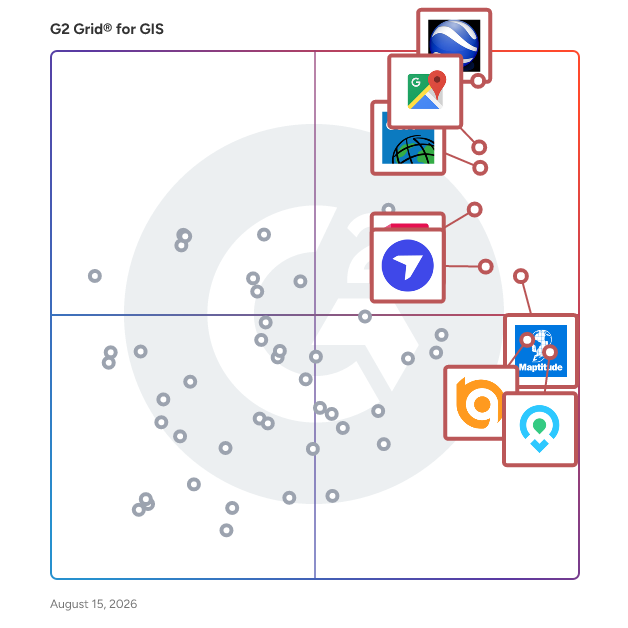
Highlighted products: Google Earth Pro, Google Maps Platform, Esri ArcGIS, AutoCAD, Maptitude, DroneDeploy, Mapme, and BatchGeo.
Underlying data: [Grid® JSON](https://www.g2.com/categories/gis/grids.json?focus%5B%5D=google-earth-pro&focus%5B%5D=google-maps-platform&focus%5B%5D=esri-arcgis&focus%5B%5D=autocad&focus%5B%5D=maptitude&focus%5B%5D=dronedeploy&focus%5B%5D=mapme&focus%5B%5D=batchgeo)
Pointpin is a simple API that gives your sites and apps fast, reliable IP geolocation (and useful location data, too). Pointpin requires no configuration or troubleshooting for users.
Postcode Map divides Australia's 2,668 postcodes among sales representatives on an interactive browser map. Every postcode carries its real boundary and its 2021 Census population. Users add representatives, give each a colour and a home pin, then drag across the map to paint postcodes into territories. A population total updates per representative during the allocation, so uneven workloads are visible while the map is being drawn rather than afterwards. A drag-box tool finds postcodes that have not been allocated, and postcodes can be shared between representatives with a split colour. Maps are saved to the cloud and open across devices. Version history keeps the last ten snapshots for rollback, and one account holds unlimited maps. Territories export to Excel or CSV, either one row per postcode or one row per representative, and postcode lists copy to the clipboard for pasting into CRM assignment rules and lead routing forms. Runs in a browser with no installation.
Precisely Boundaries are attributed vector GIS datasets that show authoritative demarcations at different granularities in over 250 countries and territories. This wide variety empowers analysis from a macro to micro level to suit your organizational needs.
Precisely Demographics is a robust collection of demographic, geodemographic, and consumer context data designed to help you understand people and the places where they live, work, and do business. These datasets offer you information for over 140 countries and territories worldwide, and empower you to conduct your analysis at the scale you need. Precisely Demographics allows you to visualize population counts and characteristics at a nationwide, statewide, census-block, or lifestyle group level, and anticipate and plan for future trends with demographic estimates and projections.
Prolo is a simple way for brands to add a product finder to their website. By leveraging the massive locations database of Foursquare, adding new retailers via the Prolo dashboard couldn't be easier, turning an intimidating process into a simple one.
ProPaving is a satellite parking lot measurement tool built for paving contractors. Using high-resolution aerial imagery, contractors can measure parking lots remotely in minutes instead of spending hours walking job sites. ProPaving helps paving companies create accurate bids faster, win more jobs, and reduce wasted site visits. Priced at $49/seat/month.
Applied Imagery offers the Quick Terrain Modeler, a leading software solution for LiDAR visualization and 3D data exploitation. This powerful, user-friendly software is designed for rapid processing of large datasets, making it suitable for applications in emergency management, mission planning, and environmental analysis. The company serves a wide range of clients, including Department of Defense and civilian users, continuously evolving based on customer feedback. Quick Terrain Modeler's sensor and coordinate system agnostic capabilities ensure compatibility with diverse 3D data sources.
RAMAS GIS is designed to link your GIS with a metapopulation model for population viability analysis (PVA) and extinction risk assessment. Habitats used by most species are becoming increasingly fragmented, requiring a metapopulation modeling approach to risk analysis. Recognizing habitat patchiness from an endangered species' point of view requires spatial information on habitat suitability. RAMAS GIS meets both of these requirements by linking metapopulation modeling with landscape data and GIS technology.
ROLTA OnPoint allows you to publish data securely over the web, connect to spatial and non-spatial data throughout your organization, turning your web-GIS into a true enterprise solution.
SitePlanCreator is a browser-based site plan tool built specifically for permit submissions. Enter any U.S. address and the platform instantly loads your property lines, building footprints, and aerial imagery from official GIS data. From there, add structures, label setbacks, adjust scale, and export a permit-ready PDF -- no CAD experience or software installation required. Used by homeowners and contractors across all 50 states for fence, deck, shed, pool, and construction permits.
SKAND is a cloud-based platform that aims to democratise spatial data by providing a user-friendly interface to manage big data challenges and visualise complex spatial data sets. The web app enables users to analyse, mark up and share spatial data with controlled access permissions.
Skylab Analytics makes sense of space based imagery and data analytics technology for global businesses with global problems. They are an independent satellite data analytics company, without any revenue commitments to any satellite data provider
SkylineGlobe Server is a private cloud solution providing a comprehensive set of web services for publishing, storing, managing, and streaming 2D and 3D geospatial content. All major GIS layer types are supported: 3D mesh, imagery, elevation, feature, and point cloud. SkylineGlobe Server lets organizations securely store, stream, and access 3D geospatial data where, when, and how they need it — serving content to TerraExplorer Desktop, Fusion (browser-based), and Mobile clients from a single managed source. Data is kept secure through virtual private geospatial servers, custom authentication, and granular user permissions — making it suitable for defense, government, and regulated enterprise deployments. SkylineCloud Hosting Services, built on SkylineGlobe Server, provides a fully managed alternative to upload, store, convert, and stream nearly unlimited 2D and 3D spatial data without on-premise infrastructure. Skyline Software Systems is ISO 9001 certified and holds a GSA Schedule and CAGE code for US federal procurement.
