Best GIS Software - Page 23

How Many GIS Software Products Does G2 Track?

Total Products under this Category: 353

Category Stats (Aug 2026)

  • Average Rating: 4.28/5 The average rating of products in this category, based on all submitted ratings
  • Top Trending Product: Octave Alto SDKs (Luciad) (+3.41%) - Among all products in this category, Octave Alto SDKs (Luciad) recorded the largest rating increase compared to last month

Last updated: August 06, 2026

How Does G2 Rank GIS Software Products?

Why You Can Trust G2's Software Rankings:

  • 30 Analysts and Data Experts
  • 8,000+ Authentic Reviews
  • 353+ Products
  • Unbiased Rankings

G2's software rankings are built on verified user reviews, rigorous moderation, and a consistent research methodology maintained by a team of analysts and data experts. Each product is measured using the same transparent criteria, with no paid placement or vendor influence. While reviews reflect real user experiences, which can be subjective, they offer valuable insight into how software performs in the hands of professionals. Together, these inputs power the G2 Score, a standardized way to compare tools within every category.
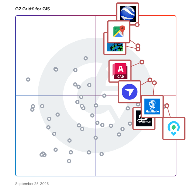
G2 Grid® for GIS Software

G2 Grid® for GIS Software plotting products by satisfaction and market presence

Highlighted products: Google Earth Pro, Google Maps Platform, Esri ArcGIS, AutoCAD, Maptitude, DroneDeploy, Mapme, and BatchGeo.

Underlying data: [Grid® JSON](https://www.g2.com/categories/gis/grids.json?focus%5B%5D=google-earth-pro&focus%5B%5D=google-maps-platform&focus%5B%5D=esri-arcgis&focus%5B%5D=autocad&focus%5B%5D=maptitude&focus%5B%5D=dronedeploy&focus%5B%5D=mapme&focus%5B%5D=batchgeo)

Sponsored

Smarty

Smarty offers global address verification, address validation, and geocoding via API, bulk upload, and a collection of 3rd party integrations that transform how organizations handle address data. With real-time address autocomplete, correction, standardization, and validation, it guarantees the accuracy and reliability of addresses. Smarty's US rooftop geocoding, reverse geocoding, and property data APIs help you enrich and hone your address data. These powerful APIs have far-reaching benefits, from improving the efficiency of your marketing campaigns to enhancing data analysis and operational processes.

Visit website

Spotzi Mapbuilder

Spotzi is a geographical data company that offers a Mapbuilder. This is an easy-to-use FREE online GIS/data mapping platform for businesses/professionals/students.

Who Is the Company Behind Spotzi Mapbuilder?

  • Seller: Spotzi
  • Year Founded: 2015
  • HQ Location: Toronto, CA
  • Twitter: @spotzicom
    74 Twitter followers
  • LinkedIn® Page: www.linkedin.com
    9 employees on LinkedIn®

Stadia Maps Location Platform

Stadia Maps is a privacy-first location infrastructure platform that provides fast, reliable map, routing, and geocoding APIs for modern applications and AI systems. It's built for teams that need global performance, transparent pricing, and human support without tracking users or locking customers in. Stadia Maps treats maps as critical infrastructure, not an ad product, and builds its services to scale from early-stage products to large enterprise systems. It's used by companies building logistics platforms, mobility services, navigation tools, and other location-aware products worldwide.

Who Is the Company Behind Stadia Maps Location Platform?

  • Seller: Stadia Maps
  • Year Founded: 2017
  • HQ Location: Waterford, US
  • Twitter: @stadiamaps
    539 Twitter followers
  • LinkedIn® Page: www.linkedin.com
    3 employees on LinkedIn®

Stream Terrain

STREAM is a native Windows desktop application for visualizing, measuring and analyzing drone-mapping and GIS terrain data. It loads large DEMs/DSMs, orthophotos, CAD drawings (DXF) and point clouds (LAS/LAZ) and renders them in a smooth, GPU-accelerated 3D environment with adaptive streaming — multi-gigabyte datasets stay fluid and interactive at full resolution, with no downsampling. Data import & layers Import GeoTIFF elevation and orthophoto rasters, DXF vector drawings and LAS/LAZ point clouds (rasterized on import to ground DEM, surface DEM or orthophoto). Stack multiple DEMs and orthophotos in a single project with per-layer visibility, opacity and priority. Coordinate system (CRS) handling with on-the-fly reprojection, and fast native caching so projects reopen instantly. Measurement & drawing Points, 3D polylines with elevation profiles, area polygons, distance/height/area measurements — all draped precisely on the terrain with snapping, editable coordinates and animated, easy-to-read labels. Terrain analysis Slope, aspect, viewshed and line-of-sight analyses, contour generation, and hydrology tools (flow paths, watersheds) — computed at full resolution and displayed as live overlays on the 3D terrain. Volumes & earthworks Cut/fill volume computation against multiple reference surfaces, stockpile management with a material library and print-ready PDF reports, and cross-section based volume tables exported to CSV/Excel and DXF. Terrain editing & scenarios Flatten, patch and re-triangulate terrain areas non-destructively — edits live in the project and can be exported baked into GeoTIFF. Keep multiple terrain scenarios (before/after, design alternatives) in one project and switch between them instantly. Export & reporting DXF (including TIN surfaces), point CSV, area-cropped GeoTIFF, contour DXF, and professional PDF map sheets and reports. STREAM is built for surveyors, mining and construction teams, and drone-mapping professionals who need CAD/GIS-grade measurement, analysis and reporting in one fast, focused tool. The interface is fully translated into 7 languages and supports both metric and imperial units.

Who Is the Company Behind Stream Terrain?

Street Smart by CycloMedia

Street Smart is our interactive web viewer for all Cyclomedia content, including GeoCycloramas and point clouds. This user-friendly interface enables fast and easy access to all our data. This includes recent, as well as historic data, allowing Cyclomedia and our clients to detect changes and examine developments over the years.

Who Is the Company Behind Street Smart by CycloMedia?

  • Seller: CycloMedia
  • Year Founded: 1980
  • HQ Location: Zaltbommel, Gelderland, Netherlands
  • Twitter: @CycloMediaUS
    199 Twitter followers
  • LinkedIn® Page: www.linkedin.com
    284 employees on LinkedIn®

SuperMap Desktop GIS 8C

SuperMap stands in a position of self-innovation, combining three major technology systems, and develops a full series of GIS platform products.

Who Is the Company Behind SuperMap Desktop GIS 8C?

  • Seller: SuperMap GIS
  • Year Founded: 1997
  • HQ Location: Beijing, CN
  • LinkedIn® Page: www.linkedin.com
    255 employees on LinkedIn®
  • Ownership: SZSE: 300036

Suplari

With Suplari, you are freed from data drudgery and armed with visibility and fresh insights each month so you can impact more decisions. Powered by advanced analytics including AI machine learning, you get a single source of truth with data automatically integrated from virtually any internal and external data sources, including your AP, purchase orders, contracts, T&E, PCard, and suppliers. Tireless algorithms comb through your haystacks of data to alert you of potential optimization opportunities along with workflow to help you prioritize and investigate. Information is rendered in a fast, modern interface so you can slice and dice into spend by supplier and contract attributes and drill down into line item detail.

Average Rating: 5.0/5.0

Total Reviews: 1

How Do G2 Users Rate Suplari?

  • Ease of Use: 6.7/10 (Category avg: 8.4/10)

Who Is the Company Behind Suplari?

  • Seller: Microsoft
  • Year Founded: 1975
  • HQ Location: Redmond, Washington
  • Twitter: @microsoft
    13,091,739 Twitter followers
  • LinkedIn® Page: www.linkedin.com
    231,632 employees on LinkedIn®
  • Ownership: MSFT

Who Uses This Product?

  • Company Size: 100% Large

What Are Recent G2 Reviews of Suplari?

Supreme Maps Downloader

Supreme Maps Downloader Pro is a powerful desktop application for downloading, previewing, and exporting high-resolution map imagery and LiDAR data. It is designed for GIS specialists, researchers, surveyors, archaeologists, urban planners, remote-sensing professionals, and anyone who works with large geospatial datasets. The integrated interactive map allows you to navigate to the required location, define an exact geographic bounding box, preview the selected imagery, and configure the download before starting the export. Geographic coordinates can be entered manually or selected directly on the map, giving you precise control over the output area. Supreme Maps Downloader Pro supports a wide range of common map-server technologies, including XYZ, TMS, QuadKey, WMTS, WMS, and ArcGIS REST services. Custom URL templates can be entered directly, making the application suitable for public, private, commercial, and self-hosted tile servers. Downloaded imagery can be exported as a georeferenced GeoTIFF or BigTIFF, allowing the resulting files to be opened directly in compatible GIS applications. BigTIFF support is especially useful for very large areas that exceed the standard TIFF size limit. The native export workflow writes the downloaded data efficiently and helps reduce unnecessary memory consumption during large jobs. The application includes configurable download zoom levels, preview zoom settings, parallel processing options, output-file selection, progress information, and a detailed activity log. Its native processing engine is designed to handle large tile collections efficiently while keeping the workflow clear and manageable. A dedicated LiDAR workspace provides access to compatible elevation and point-cloud data sources. This makes Supreme Maps Downloader Pro suitable for projects involving terrain analysis, surface modelling, infrastructure inspection, environmental research, archaeology, and three-dimensional geospatial analysis.

Who Is the Company Behind Supreme Maps Downloader?

Tactical AVL

Tactical AVL is a modern unit coordination platform that provides officers in charge with maximum situational awareness for effective incident response. Enabling swift decision-making, synchronizing response efforts, and handling emergencies with confidence, it is trusted by disaster response units, law enforcement agencies, and private security forces in over 50 countries. Benefit from a comprehensive set of features including location tracking, geofencing, sensor alerting, integrated data and video feeds, field reporting, and many more.

Average Rating: 4.3/5.0

Total Reviews: 2

How Do G2 Users Rate Tactical AVL?

  • Ease of Use: 8.3/10 (Category avg: 8.4/10)

Who Is the Company Behind Tactical AVL?

Who Uses This Product?

  • Company Size: 50% Large, 50% Small

What Do G2 Reviewers Say About Tactical AVL?

AI-generated summary from verified user reviews

Pros
  • Users value the accurate real-time tracking of Tactical AVL, enhancing asset and unit monitoring during operations.
  • Users commend the user-friendly interface of Tactical AVL, enhancing situational awareness and facilitating quick response times.
  • Users appreciate the easy learning curve of Tactical AVL, enabling quick mastery of its features for effective tracking.
  • Users value the accurate real-time tracking in Tactical AVL, enhancing monitoring and operational efficiency.
  • Users value the accurate real-time tracking of Tactical AVL, enhancing operational efficiency and situational awareness.
Cons
  • Users find the difficult setup of Tactical AVL time-consuming, though the performance is ultimately reliable and efficient.
  • Users find the learning curve challenging, as initial setup can be time-consuming before enjoying Tactical AVL's benefits.

What Are Recent G2 Reviews of Tactical AVL?

TargomoAPI

Travel times, Routing, Points of Interests, Isochrone Polygons - Targomo offers high-performant developer tools to build state-of-the-art geospatial analytics tools, enhance location search and personalize user experience. Fast & performant: With fast processing and very precise routing, Targomo’s developer tools provides everything you need to build high-end geospatial applications. Highly customizable: Built-in customization options that let you adapt your solution to all individual scenarios, no matter how complex they are. Advanced Analytics: Go beyond standard offerings - use calculated travel times to points of interest and other statistical data sets to develop more features and provide additional insights to the user of your application. PLUS: Pay-as-you-go pricing for public and free applications incl. €300 free monthly credit + attractive volume pricing

Who Is the Company Behind TargomoAPI?

  • Seller: Targomo
  • Year Founded: 2013
  • HQ Location: Berlin, DE
  • Twitter: @targomo
    1,212 Twitter followers
  • LinkedIn® Page: www.linkedin.com
    22 employees on LinkedIn®

TargomoLOOP

TargomoLOOP is a location optimization tool that assists brick-and-mortar businesses such as shops, restaurants, and service providers in strategic location planning and decision-making. TargomoLOOP is a centralized platform for managing all of your business's location-based information, including customer demographics, retail sales, and service area offerings. Insights gained from this method can be used to examine and enhance retail and hospitality locations, as well as to plot development and optimize the network. Analytics powered by AI can accurately predict sales with an accuracy of 80-90%, as well as find the success drivers of firms and growth possibilities.

Average Rating: 4.0/5.0

Total Reviews: 1

How Do G2 Users Rate TargomoLOOP?

  • Ease of Use: 8.3/10 (Category avg: 8.4/10)

Who Is the Company Behind TargomoLOOP?

  • Seller: Targomo
  • Year Founded: 2013
  • HQ Location: Berlin, DE
  • Twitter: @targomo
    1,212 Twitter followers
  • LinkedIn® Page: www.linkedin.com
    22 employees on LinkedIn®

Who Uses This Product?

  • Company Size: 100% Small

What Do G2 Reviewers Say About TargomoLOOP?

AI-generated summary from verified user reviews

Pros
  • Users value the effective geospatial analysis of TargomoLOOP for strategic new store location planning.
  • Users value TargomoLOOP for its effective map creation, aiding in strategic decisions for new store locations.
  • Users find the powerful tools of TargomoLOOP essential for strategically identifying optimal store locations using heat maps.

What Are Recent G2 Reviews of TargomoLOOP?

Tasmap

Tasmap is a tool that lets you create personalized maps for travel planning, local guides, favorite spots, and more. You can customize colors, icons, and markers while linking maps with stories to create an interactive experience. No design experience? AI can help generate styles and auto-mark locations, saving you time and effort. Your maps can be added to the home screen for quick access, just like an app, and easily shared with others. With no ads and a focus on privacy, Tasmap provides a clean space for you to design and share your own maps and stories.

Who Is the Company Behind Tasmap?

Tenchijin

Tenchijin is a space tech company that uses satellite data for land evaluation, helping businesses to make informed decisions.

Who Is the Company Behind Tenchijin?

  • Seller: Tenchijin
  • Year Founded: 2019
  • HQ Location: Minato-city, JP
  • LinkedIn® Page: www.linkedin.com
    35 employees on LinkedIn®

Ticon

Ticon is a recognized leader in location intelligence and vehicular traffic analysis. Our solutions produce hi-res data with unmatched precision and proven accuracy that give businesses actionable data-driven insights needed to make optimal strategic decisions. Ticon's solutions for site selection, network optimization and operations analytics for retail are available through both subscription-free reports and a platform. Whether you're expanding or optimizing, Ticon helps identify prime locations and enhances operational efficiency for increased profitability.

Who Is the Company Behind Ticon?

  • Seller: Ticon
  • Year Founded: 2016
  • HQ Location: Lewes, US
  • LinkedIn® Page: www.linkedin.com
    9 employees on LinkedIn®

Tile Server Setup

Tile Server Setup is a native Windows desktop application for hosting raster maps as a local XYZ tile service. It is designed for GIS professionals, developers, researchers, and anyone who needs to quickly publish map tiles from their own computer without relying on external cloud services. The application includes an integrated interactive preview, allowing you to verify your map immediately after starting the server. Large datasets can be served efficiently using the bundled GDAL environment, while the built-in HTTPS support enables encrypted local connections. Key Features Serve local raster datasets as an XYZ tile server Integrated live map preview Automatic server start and stop Native C++ application with high performance Bundled WebView2-based preview Integrated GDAL tools for raster processing Local HTTPS support using native Windows Schannel Supports localhost and local network access Simple, modern user interface No cloud services required Works completely offline Ideal for GIS workflows, development, and testing Whether you are testing web mapping applications, preparing GIS projects, or sharing map tiles across your local network, Tile Server Setup provides a lightweight and efficient solution that runs entirely on your own computer while keeping your data under your control.

Who Is the Company Behind Tile Server Setup?

  • Seller: Microsoft
  • Year Founded: 1975
  • HQ Location: Redmond, Washington
  • Twitter: @microsoft
    13,091,739 Twitter followers
  • LinkedIn® Page: www.linkedin.com
    231,632 employees on LinkedIn®
  • Ownership: MSFT

tMap

tMap is a GIS software that is is an easy to use measuring application, with an advanced functionality. The program has been designed for the Android operating system and can be used on tablets, smartphones and other mobile devices (handheld).

Who Is the Company Behind tMap?

  • Seller: Taxus IT
  • Year Founded: 2013
  • HQ Location: Warszawa, PL
  • LinkedIn® Page: www.linkedin.com
    22 employees on LinkedIn®
Daniel Rivera
DR
Researched and written by Daniel Rivera
Updated March 4, 2025