Best GIS Software for Small Business - Page 3

How Many GIS Software Products Does G2 Track?

Total Products under this Category: 444

Category Stats (Oct 2026)

  • Average Rating: 4.3/5 The average rating of products in this category, based on all submitted ratings
  • Top Trending Product: Smappen (+7.62%) - Among all products in this category, Smappen recorded the largest rating increase compared to last month

Last updated: October 14, 2026

How Does G2 Rank GIS Software Products?

Why You Can Trust G2's Software Rankings:

  • 30 Analysts and Data Experts
  • 8,200+ Authentic Reviews
  • 444+ Products
  • Unbiased Rankings

G2's software rankings are built on verified user reviews, rigorous moderation, and a consistent research methodology maintained by a team of analysts and data experts. Each product is measured using the same transparent criteria, with no paid placement or vendor influence. While reviews reflect real user experiences, which can be subjective, they offer valuable insight into how software performs in the hands of professionals. Together, these inputs power the G2 Score, a standardized way to compare tools within every category.

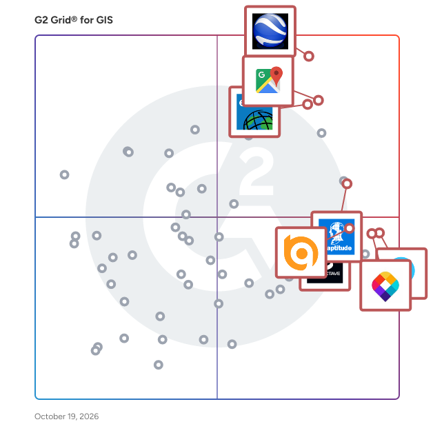
G2 Grid® for GIS Software

G2 Grid® for GIS Software plotting products by satisfaction and market presence

Highlighted products: Esri ArcGIS, Google Maps Platform, Google Earth Pro, Octave Imagine, Mapme, Maptitude, MapTiler, and BatchGeo.

Underlying data: [Grid® JSON](https://www.g2.com/categories/gis/grids.json?focus%5B%5D=esri-arcgis&focus%5B%5D=google-maps-platform&focus%5B%5D=google-earth-pro&focus%5B%5D=octave-imagine&focus%5B%5D=mapme&focus%5B%5D=maptitude&focus%5B%5D=maptiler&focus%5B%5D=batchgeo&segment=small-business)

Maptive

Maptive is a comprehensive set of mapping tools built with users in mind. Our mapping software provides businesses from small non-profits to enterprise-level corporations with a wide range of geospatial analysis and data visualization capabilities. Upload location data from spreadsheets or CRMs to Maptive's platform and apply our features to quickly create custom maps, including heat maps, color-coded pin maps, sales territory maps, optimized routes and directions, and demographic maps.

Average Rating: 4.7/5.0

Total Reviews: 34

How Do G2 Users Rate Maptive?

  • Data Capture: 8.8/10 (Category avg: 8.6/10)
  • Data Visualization: 9.5/10 (Category avg: 8.6/10)
  • Ease of Use: 9.2/10 (Category avg: 8.4/10)
  • Spatial Analysis: 9.3/10 (Category avg: 8.5/10)

Who Is the Company Behind Maptive?

  • Seller: Maptive
  • Year Founded: 2013
  • HQ Location: San Francisco, CA
  • Twitter: @Maptive
    572 Twitter followers
  • LinkedIn® Page: www.linkedin.com
    5 employees on LinkedIn®

Who Uses This Product?

  • Company Size: 66% Small, 29% Medium

What Do G2 Reviewers Say About Maptive?

AI-generated summary from verified user reviews

Pros
  • Users value the quick and helpful customer support from Maptive, enhancing the overall user experience significantly.
  • Users value the ease of use of Maptive, enabling quick map creation and data analysis without extensive training.
  • Users appreciate Maptive's excellent service, citing quick support and helpful responses that enhance their experience.
  • Users value the powerful and easy-to-use features of Maptive, enabling effective data visualization and quicker decision-making.
  • Users find Maptive's helpful support invaluable, improving decision-making speed and enhancing map presentation for stakeholders.
Cons
  • Users face some learning difficulty initially, but tutorials and live chat help ease the transition swiftly.

What Are Recent G2 Reviews of Maptive?

What Are G2 Users Discussing About Maptive?

Octave GeoMedia

GeoMedia is a powerful, flexible GIS management platform that lets you aggregate data from a variety of sources and analyze them in unison to extract clear, actionable information. It provides simultaneous access to geospatial data in almost any form and displays it in a single unified map view for efficient processing, analysis, presentation, and sharing. GeoMedia’s functionality makes it ideal for extracting information from an array of dynamically changing data to support making informed, smarter decisions.

Average Rating: 3.9/5.0

Total Reviews: 22

How Do G2 Users Rate Octave GeoMedia?

  • Data Capture: 8.1/10 (Category avg: 8.6/10)
  • Data Visualization: 8.3/10 (Category avg: 8.6/10)
  • Ease of Use: 7.7/10 (Category avg: 8.4/10)
  • Spatial Analysis: 8.5/10 (Category avg: 8.5/10)

Who Is the Company Behind Octave GeoMedia?

Who Uses This Product?

  • Company Size: 59% Small, 30% Medium

What Are Recent G2 Reviews of Octave GeoMedia?

What Are G2 Users Discussing About Octave GeoMedia?

Land id (formerly MapRight)

Land id™ & Land id Pro enables real estate professionals, ranchers, farmers, appraisers, builders, landowners, and anyone curious about land to discover extensive private parcel data, create & showcase powerful, shareable, interactive maps.

Average Rating: 4.3/5.0

Total Reviews: 15

How Do G2 Users Rate Land id (formerly MapRight)?

  • Data Capture: 8.9/10 (Category avg: 8.6/10)
  • Data Visualization: 8.3/10 (Category avg: 8.6/10)
  • Ease of Use: 8.8/10 (Category avg: 8.4/10)
  • Spatial Analysis: 8.3/10 (Category avg: 8.5/10)

Who Is the Company Behind Land id (formerly MapRight)?

  • Seller: Land id
  • Year Founded: 2014
  • HQ Location: Dallas, TX
  • Twitter: @landidofficial
    1,410 Twitter followers
  • LinkedIn® Page: www.linkedin.com
    50 employees on LinkedIn®

Who Uses This Product?

  • Company Size: 80% Small, 13% Medium

What Are Recent G2 Reviews of Land id (formerly MapRight)?

What Are G2 Users Discussing About Land id (formerly MapRight)?

AI can help you find the answers. G2 helps you trust them.

Connect G2 to Claude or ChatGPT for answers grounded in G2's trusted reviews, comparisons, and pricing from real user insights.

How it works

Global Mapper

Global Mapper’s intuitive user interface and logical layout help smooth the learning curve and ensure that users will be up-and-running in no time. To add to the usability, nearly 400 file formats are supported for import and export. This all-in-one software allows users to complete their entire workflow within the same software with tools such as contour creation, watershed analysis, and multiband raster calculations. Top Tools Include: • Access to online data sources for streaming imagery, terrain and vector data • Immersive 3D visualization • Workflow automation with scripting • Site plan with cut and fill analysis • Generate terrain models (REM, DSM, and DEM) • Terrain analysis including contour generation and path profile Global Mapper Pro® expands upon the extensive functionality of the standard version of the application. Users can take advantage of the comprehensive collection of tools for advanced 3D analysis, lidar and photogrammetric point cloud processing, drone-collected image analysis, Python scripting methods, machine-learning integration and much more. Award-winning machine learning has been integrated with the beloved automatic point cloud classification. In addition to the built-in models for auto-classifying ground, building, vegetation and powerline points, custom classes can be created by users. Top Tools Include: • Pixels to Points: Photogrammetric toolset • Filtering and editing of lidar point clouds • Automatic classification of ground, vegetation, buildings, power lines, and poles • Terrain Painting • Solar analysis from loaded terrain and 3D features • Global Mapper Insight and Learning Engine: Deep-learning powered object detection and land cover classification Developed for both GIS professionals and map enthusiasts, Global Mapper® has all the functionality you need in a GIS software. Take GIS into the field with Global Mapper Mobile. This iOS and Android application makes viewing and collecting data on-the-go easy. • Display vector, raster, and elevation layers • Drawing, tracing and form-based collection • Connection to GNSS and GPS receivers • Terrain Analysis: contour creation, volume calculation and viewshed

Average Rating: 4.3/5.0

Total Reviews: 30

How Do G2 Users Rate Global Mapper?

  • Data Capture: 8.7/10 (Category avg: 8.6/10)
  • Data Visualization: 8.7/10 (Category avg: 8.6/10)
  • Ease of Use: 7.8/10 (Category avg: 8.4/10)
  • Spatial Analysis: 8.0/10 (Category avg: 8.5/10)

Who Is the Company Behind Global Mapper?

  • Seller: Blue Marble
  • Year Founded: 1993
  • HQ Location: Hallowell, ME
  • Twitter: @BlueMarbleGeo
    1,854 Twitter followers
  • LinkedIn® Page: www.linkedin.com
    57 employees on LinkedIn®

Who Uses This Product?

  • Top Industries: Oil & Energy, Civil Engineering
  • Company Size: 40% Medium, 33% Small

What Are Recent G2 Reviews of Global Mapper?

What Are G2 Users Discussing About Global Mapper?

GIS Mapviewer

PubWorks MapViewer is an advanced GIS (Geographic Information System) module designed to seamlessly integrate with the PubWorks suite, providing public works departments with a dynamic visual representation of their assets and operations. By overlaying asset data onto interactive maps, MapViewer enhances spatial awareness and facilitates more informed decision-making. Key Features and Functionality: - Asset Visualization: Display various public works assets, such as roads, utilities, and facilities, directly on a GIS map, allowing for immediate spatial context. - Service Request Mapping: Instantly project service requests onto the map, enabling quick identification of issues and efficient resource allocation. - Work Order Integration: Map work orders to visualize ongoing and scheduled tasks, ensuring clarity in work distribution and progress tracking. - Attribute Inspection: Access detailed asset attributes within the map interface, providing comprehensive information without leaving the visual context. - Clipboard and Reporting: Select multiple assets, copy them to the clipboard, and generate tailored reports, streamlining data analysis and reporting processes. Primary Value and User Solutions: MapViewer addresses the challenge of managing and interpreting vast amounts of asset data by offering a spatially intuitive platform. Users can quickly locate assets, assess service requests, and monitor work orders, leading to improved operational efficiency and more effective resource deployment. The integration of GIS mapping with PubWorks' data ensures that public works departments can make data-driven decisions with a clear understanding of geographic implications.

Average Rating: 4.4/5.0

Total Reviews: 15

How Do G2 Users Rate GIS Mapviewer?

  • Data Capture: 9.5/10 (Category avg: 8.6/10)
  • Data Visualization: 9.2/10 (Category avg: 8.6/10)
  • Ease of Use: 8.2/10 (Category avg: 8.4/10)
  • Spatial Analysis: 8.8/10 (Category avg: 8.5/10)

Who Is the Company Behind GIS Mapviewer?

  • Seller: Tracker Software
  • Year Founded: 1997
  • HQ Location: Snowmass Village, US
  • Twitter: @PubWorks1
    42 Twitter followers
  • LinkedIn® Page: www.linkedin.com
    7 employees on LinkedIn®

Who Uses This Product?

  • Company Size: 80% Small, 13% Large

What Do G2 Reviewers Say About GIS Mapviewer?

AI-generated summary from verified user reviews

Pros
  • Users praise the data visualization capabilities of GIS Mapviewer, enhancing their ability to create interactive maps efficiently.
  • Users commend GIS Mapviewer for its powerful geospatial analysis, allowing effective visualization of diverse data types in interactive maps.
  • Users value the interactive mapping capabilities of GIS Mapviewer, which effectively integrates and visualizes diverse data types.
Cons
  • Users face a steeper learning curve with GIS Mapviewer, impacting their overall user experience and efficiency.
  • Users report significant technical issues, including performance problems and a challenging learning curve with GIS Mapviewer.

What Are Recent G2 Reviews of GIS Mapviewer?

What Are G2 Users Discussing About GIS Mapviewer?

GeoServer

Designed for interoperability, GeoServer publishes data from any major spatial data source using open standards. GeoServer implements industry standard OGC protocols such as Web Feature Service (WFS), Web Map Service (WMS), and Web Coverage Service (WCS). Additional formats and publication options are available as extensions including Web Processing Service (WPS), and Web Map Tile Service (WMTS).

Average Rating: 4.5/5.0

Total Reviews: 20

How Do G2 Users Rate GeoServer?

  • Data Capture: 8.2/10 (Category avg: 8.6/10)
  • Data Visualization: 8.2/10 (Category avg: 8.6/10)
  • Ease of Use: 8.9/10 (Category avg: 8.4/10)
  • Spatial Analysis: 7.7/10 (Category avg: 8.5/10)

Who Is the Company Behind GeoServer?

  • Seller: GeoServer
  • Year Founded: 2020
  • HQ Location: İstanbul, İstanbul
  • Twitter: @geoserver
    20 Twitter followers
  • LinkedIn® Page: www.linkedin.com
    1 employees on LinkedIn®

Who Uses This Product?

  • Top Industries: Environmental Services
  • Company Size: 52% Small, 40% Medium

What Are Recent G2 Reviews of GeoServer?

What Are G2 Users Discussing About GeoServer?

Daniel Rivera
DR
Researched and written by Daniel Rivera
Updated