Realgar AI Digital Twin
Who Is the Company Behind Realgar AI Digital Twin?
- Seller: Realgar AI Digital Twin
- HQ Location: N/A
-
LinkedIn® Page: www.linkedin.com
1 employees on LinkedIn®
Total Products under this Category: 145
Last updated: September 01, 2026
Why You Can Trust G2's Software Rankings:
G2's software rankings are built on verified user reviews, rigorous moderation, and a consistent research methodology maintained by a team of analysts and data experts. Each product is measured using the same transparent criteria, with no paid placement or vendor influence. While reviews reflect real user experiences, which can be subjective, they offer valuable insight into how software performs in the hands of professionals. Together, these inputs power the G2 Score, a standardized way to compare tools within every category.
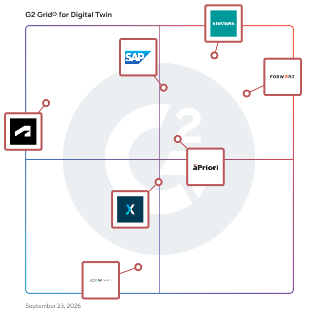
Highlighted products: Tecnomatix, Forward Enterprise, SAP Business Technology Platform, aPriori Manufacturing Intelligence Platform, XMPro, Autodesk Digital Twin, and Agora World.
Underlying data: [Grid® JSON](https://www.g2.com/categories/digital-twin/grids.json?focus%5B%5D=tecnomatix&focus%5B%5D=forward-enterprise&focus%5B%5D=sap-business-technology-platform&focus%5B%5D=apriori-manufacturing-intelligence-platform&focus%5B%5D=xmpro&focus%5B%5D=autodesk-digital-twin&focus%5B%5D=agora-world)
SAIM (Smart Asset Integrity Management) is a modern, cloud-based platform that empowers infrastructure and operations teams to manage facilities, assets, and field data with greater visibility, accountability, and speed. Designed for field-centric industries, SAIM connects maintenance, monitoring, and digital twin capabilities in one seamless system, eliminating siloed tools and outdated workflows. Core Capabilities: Maintenance Management SAIM streamlines inspections, recurring tasks, and work orders through a mobile-first interface called SAIM Inspect. Field teams capture data on-site while managers assign and track progress from anywhere,boosting compliance and accelerating response times. Real-Time Monitoring Stay ahead of operational risk with signal tracking for tanks, sensors, meters, and more. SAIM’s Monitoring module gives you visibility into infrastructure conditions, anomalies, and trends, enabling faster decisions and better accountability. Digital Twin & As-Built Visualization SAIM’s As-Builts brings together CAD files, measurements, and site documentation into an interactive digital twin platform perfect for construction handoff, infrastructure audits, and long-term planning. Use Case Spotlight: Fuel Operations From fence to wing, SAIM supports a full-spectrum fuel management use case by combining real-time monitoring, mobile inspections, asset data and much more. Track usage and tank levels, prevent overfills, and maintain complete fueling records with SAIM’s integrated approach. Key fuel capabilities include: - Parts inventory management software - Real-time fuel monitoring systems - Support for aviation fuel management software needs - Alerting, compliance logging, and audit trails Whether your fuel team spans a single airport or a regional network, SAIM gives you the visibility and control to stay proactive and efficient. Built for Any Industry SAIM is built to support a range of infrastructure-driven industries. These can include oil and gas, energy, water treatment, government, military, transportation, manufacturing and more. Our platform is configurable, scalable, and evolving quickly—with our flexible architecture allowing teams to tailor reporting, user roles, and data structures to their specific operational needs. Results That Matter ✔️ Reduce downtime and operational risk ✔️ Improve audit readiness and compliance tracking ✔️ Enhance asset performance and lifecycle planning ✔️ Consolidate siloed systems into one connected platform SAIM supports proactive maintenance planning today and is engineered for predictive insights tomorrow. With configurable architecture and continuous updates, SAIM evolves as your operation does. Why SAIM? If you're searching for modern facilities management software, asset performance management tools, or a platform that centralizes infrastructure oversight, SAIM is built to simplify your stack and elevate your strategy.
Average Rating: 4.9/5.0
Total Reviews: 20
AI-generated summary from verified user reviews
"Effortless Paperless Maintenance and Outstanding Support"
Rating: 5.0/5.0 stars
— Marcelino G.
"Comprehensive Monitoring and Reporting Made Easy"
Rating: 4.5/5.0 stars
— Jackie H.
Sandhed is a digital twin platform for manufacturers. Upload your facility floor plan and it becomes an interactive 3D environment showing live sensor data, machine statuses, and asset positions. It connects to 150+ industrial protocols, including OPC UA, MQTT, and Modbus, so it talks to whatever PLCs and sensors you already have on the floor. You can ask questions about your operations in plain language and get answers from live data. Take a photo of any piece of equipment and the AI generates a 3D model of it.
SAP Digital Manufacturing solution is a manufacturing execution system (MES) that supports sustainable, risk-resilient manufacturing operations through a resource-efficient Industry 4.0 approach. Cloud deployment Visibility across the top floor and shop floor Powerful KPIs and analytics Precision execution of production processes Improved operator productivity with machine learning for visual inspection
Digital twins track dynamic state information for each data source and make it instantly available to application code inspecting incoming messages. This lets the application focus on exactly what its data sources are telling it so that it can do a better job of predicting whats next.
Seebo's cloud-based software combines tools for IoT Modeling, Simulation, Execution, and Behavior Analytics into pre-packaged business solutions that address new product innovation, product resilience, venue operational excellence, and data-driven services.
Average Rating: 4.5/5.0
Total Reviews: 1
Rating: 4.5/5.0 stars
— Gorinta M.
At InContext, our virtual solutions are powered by ShopperMX™-- the world’s first cloud-based virtual reality simulation and shopper insights platform that enables users to create and test new shopper experiences in hyper realistic 3D virtual store simulations. This cutting-edge enterprise virtual reality platform gives you the power to create engaging shopper experiences no matter your industry. Retailers and manufacturers gain in-depth perspectives and insights for faster, smarter, more profitable business decisions that effectively speed up innovation and improve profits.
Average Rating: 4.5/5.0
Total Reviews: 1
"Wonderfully done and super easy to use."
Rating: 4.5/5.0 stars
— Cameron H.
SkySpecs Renewable Asset Performance Management helps renewable energy owners and operators improve, and optimize, the operational and financial performance of their assets. SkySpecs supports the full asset lifecycle through our purpose-built software and technology-enabled services by connecting critical asset data with actionable insights, helping teams understand asset health, identify emerging risks, prioritize maintenance, and make more informed decisions across their fleets. By bringing these capabilities together, SkySpecs helps customers reduce downtime, optimize maintenance spending, extend asset life, and maximize energy production and revenue. SkySpecs enables teams to move from fragmented data and reactive maintenance toward more proactive, efficient, and performance-driven asset management.
Terminus Group's Smart Devices are advanced AI-powered robots designed to enhance urban living through intelligent automation and interactive services. These devices integrate cutting-edge artificial intelligence and Internet of Things (IoT) technologies to perform a variety of tasks, including security patrols, environmental monitoring, and public information dissemination. By seamlessly blending into urban environments, they contribute to the development of smart cities by improving operational efficiency and providing real-time data insights.
Smart Spatial is a 3D operational digital twin platform that transforms how organizations manage sales and marketing, operations, training, simulation, and synthetic data generation. It brings together architectural models, live telemetry, and contextual data into an interactive spatial environment, making complex systems easier to understand, operate, and optimize. Use Cases & Value Creation 1. Operations Management Audience: Facility Managers, Directors of Operations, Asset Owners Smart Spatial gives real-time insight into HVAC, electrical, and mechanical systems through 3D visualization integrated with live IoT data. Teams quickly identify system inefficiencies, avoid costly failures, and ensure compliance with safety standards. The spatial context reduces cognitive errors typical in 2D systems, improving uptime, reducing operating costs, and ensuring faster response to incidents. 2. Sales & Marketing Enablement Audience: Sales Engineers, Business Developers, Product Teams Sales teams use Smart Spatial to visually communicate infrastructure, workflows, or product capabilities in a real-world context. This helps prospects instantly grasp complex environments and builds confidence during the sales cycle. It's particularly powerful for showcasing innovations like smart building integrations or industrial system designs without requiring site visits. 3. Training & Onboarding Audience: HR, Safety Trainers, System Engineers Smart Spatial accelerates learning by placing new hires and contractors inside interactive 3D models of real facilities. Teams can virtually explore equipment, safety zones, and procedures, reducing onboarding time and lowering human error. Training becomes continuous and immersive, especially valuable for high-risk or regulated environments. 4. Simulation & Scenario Planning Audience: Engineering, Risk Management, Project Planning Users simulate upgrades, maintenance, or failure scenarios in a safe, virtual space before real-world execution. This allows better planning, coordination between stakeholders, and lower risk in critical infrastructure changes. 5. Synthetic Data Generation for AI Development Audience: AI/ML Engineers, Product Developers The platform can be used to create synthetic datasets from digital twins, enabling AI training for visual recognition, robotics, or predictive maintenance without compromising real data. This is crucial for environments with limited access or high privacy requirements. Industries Served Smart Spatial is relevant across a wide range of industries, including: - Commercial Real Estate - Data Centers - Manufacturing and Warehouses - Oil and Gas - Retailers - Healthcare Facilities - Education Campuses - Airports, Ports, Railroads & Transportation Hubs - Utilities, Energy, Infrastructure - Government Buildings - R&D and Defense Facilities Why Smart Spatial Smart Spatial aligns the complexity of physical infrastructure with the clarity of a spatial interface. It reduces downtime, shortens sales cycles, improves learning, and helps teams make faster, safer, and more informed decisions. Whether you’re managing a mission-critical facility, closing a multi-million dollar deal, or training the next generation of workers, Smart Spatial turns your environment into a competitive advantage—viewable, testable, and actionable in 3D.
What is SolonPort TOS? SolonPort TOS is a Terminal Operating System (TOS) developed by SolonPort, with a European office in Amsterdam, the Netherlands, and an engineering center in Istanbul, Turkey. This international presence allows SolonPort to serve ports and terminals worldwide with local responsiveness, regional expertise, and round-the-clock support across time zones. With 30+ years of software development and project management experience in the port industry, SolonPort has become a trusted name in port automation. The company has successfully implemented and managed systems for nearly 20 national and international ports, serving terminals that handle a wide range of cargo types, including general and bulk cargo, liquid cargo, containers, and Ro-Ro operations. The platform is built on a modular architecture, covering the full scope of terminal operations: vessel planning, dock and yard management, gate operations, weighbridge, customs processing, and warehouse management. This modularity allows terminals of any size or region to adopt only the modules they need and scale as their operations grow. SolonPort also offers unmanned, fully automated solutions such as an Automatic Gate System and an Automatic Weighbridge System, reducing manual intervention and increasing operational accuracy. The company has pioneered forward-looking initiatives in the sector, including a Digital Twin project, 3D Smart Yard Management, and a 3D Port Management Mobile App, bringing real-time visualization and simulation capabilities to terminal operations. Deployment options are flexible: terminals can choose fully automatic, hybrid, semi-automatic, or semi-manual configurations depending on their operational needs and existing infrastructure. From its Amsterdam office on Keizersgracht, in the heart of the city's historic canal district, SolonPort maintains close proximity to European markets and global shipping networks. The Istanbul engineering center, located within Istanbul University's Avcılar Campus technology park (Teknokent), keeps the company's product development closely connected to a strong academic and R&D ecosystem in maritime technology. SolonPort's core philosophy remains centered around the customer: rather than offering a rigid, one-size-fits-all product, the team works closely with each port to identify specific requirements through field studies, then configures the modular system accordingly — ensuring the software fits the terminal's real workflow instead of forcing the terminal to adapt to the software.
"Solon Port are Proficient within the Terminal Software Markets"
Rating: 5.0/5.0 stars
— Richard B.
StellaSpark Nexus is a real-time digital twin platform for monitoring and simulating the natural and built environment across sectors such as urban planning, public safety, construction, water management, energy, mobility, telecommunications, forestry, and environmental management. It enables governments, NGOs, utilities, contractors, engineers, and technical consultants to automate environmental compliance, identify risks and opportunities, quantify the impact of infrastructure projects or environmental change, track progress toward policy objectives and save time by seamlessly sharing data with partner organizations and public stakeholders. The platform integrates live data from virtually any source - including IoT sensors, geospatial datasets, photos, and web-scraped feeds - and transforms it into performant, interactive 2D and 3D maps and time-series charts that are always up-to-date. Users can simulate scenarios, calculate metrics or continously generate operational forecasts by deploying physics-based models, machine learning algorithms, or their own custom scripts directly within the digital twin. Secure APIs and open data portal functionality make it easy to share data and insights with partners, public stakeholders, and external tools. # Features ## Link map features with timeseries and photos Select any feature on the map to view its live sensor data, historical trends, associated properties or photos. This cuts investigation time from hours to minutes. ## Visualize in 2D or 3D Bring raster and vector data to life in 2D or 3D maps. Apply rule-based or data-driven coloring to map features to highlight locations with anomalies. Time travel to inspect historical states or modeled future scenarios. ## Explore time series with interactive charts Connect sensor measurements to spatial objects or regions and display results in interactive charts. Visualize thresholds to detect exceedances of safety, compliance, or operational limits. Chart configuration supports custom indicators, aggregation methods, and domain-specific layouts. ## Connect anything Integrate data from virtually any spatial format and protocol (KML, GML, GeoJSON, Geotiff, WMTS, WFS, HDF, NetCDF, Shapefile), photos, time series from IoT devices and sensors such as JSON, CSV, XML or semi-structured data from websites. Use one of the 200+ data sources already available in Nexus or bring your own. ## Always up-to-date Keep data at its original source and let Nexus connect to it to bring it to life. Maps and charts update continuously, ensuring the digital twin reflects the current state of assets and environments without requiring manual re-imports or refreshes. ## Operational forecasting and scenario analysis Get decision support by simulating based on live data rather than static model inputs. Deploy built-in or user-supplied calculations, such as scripts in any programming language, trained machine learning algorithms, or physics-based models. Supported use cases include: - Scenario modeling (“what-if” studies) - Policy and performance indicator generation - Compliance and safety limit evaluation - Spatial interpolation - Continous operational forecasting ## Work from anywhere on any device Access the digital twin in the field or in the office. The browser-based viewer runs on desktop, tablet, and mobile without additional software installation. ## Share data with partners and citizens Use Nexus as an open data portal, or securily connect Nexus to external applications through REST APIs or direct database connections for programmatic access. Supported ecosystem integrations include GIS platforms (ArcGIS Online, QGIS), BI and analytics tools (Tableau, Power BI), and Python workflows for custom processing and automation.
