Best GIS Software - Page 10

How Many GIS Software Products Does G2 Track?

Total Products under this Category: 414

Category Stats (Sep 2026)

  • Average Rating: 4.29/5 The average rating of products in this category, based on all submitted ratings
  • Top Trending Product: Smappen (+9.51%) - Among all products in this category, Smappen recorded the largest rating increase compared to last month

Last updated: September 01, 2026

How Does G2 Rank GIS Software Products?

Why You Can Trust G2's Software Rankings:

  • 30 Analysts and Data Experts
  • 8,100+ Authentic Reviews
  • 414+ Products
  • Unbiased Rankings

G2's software rankings are built on verified user reviews, rigorous moderation, and a consistent research methodology maintained by a team of analysts and data experts. Each product is measured using the same transparent criteria, with no paid placement or vendor influence. While reviews reflect real user experiences, which can be subjective, they offer valuable insight into how software performs in the hands of professionals. Together, these inputs power the G2 Score, a standardized way to compare tools within every category.

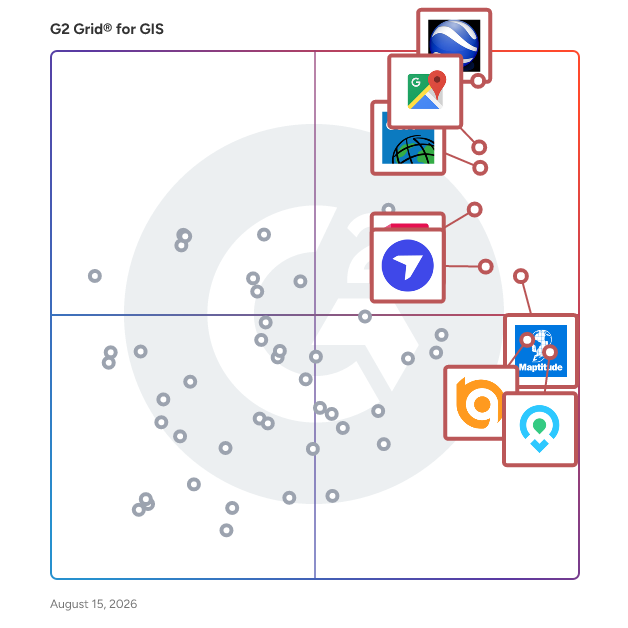
G2 Grid® for GIS Software

G2 Grid® for GIS Software plotting products by satisfaction and market presence

Highlighted products: Google Earth Pro, Google Maps Platform, Esri ArcGIS, AutoCAD, Maptitude, DroneDeploy, Mapme, and BatchGeo.

Underlying data: [Grid® JSON](https://www.g2.com/categories/gis/grids.json?focus%5B%5D=google-earth-pro&focus%5B%5D=google-maps-platform&focus%5B%5D=esri-arcgis&focus%5B%5D=autocad&focus%5B%5D=maptitude&focus%5B%5D=dronedeploy&focus%5B%5D=mapme&focus%5B%5D=batchgeo)

REGIS Online

REGIS creates online and desktop software to help brokers, retailers, developers or cities find great sites through mapping and demographic analysis.

Average Rating: 5.0/5.0

Total Reviews: 2

How Do G2 Users Rate REGIS Online?

  • Data Capture: 10.0/10 (Category avg: 8.6/10)
  • Data Visualization: 9.2/10 (Category avg: 8.6/10)
  • Ease of Use: 9.2/10 (Category avg: 8.4/10)
  • Spatial Analysis: 10.0/10 (Category avg: 8.4/10)

Who Is the Company Behind REGIS Online?

  • Seller: Sites USA
  • HQ Location: Chandler, US
  • Twitter: @sitesusa
    303 Twitter followers
  • LinkedIn® Page: www.linkedin.com
    29 employees on LinkedIn®

Who Uses This Product?

  • Company Size: 100% Small

What Are Recent G2 Reviews of REGIS Online?

What Are G2 Users Discussing About REGIS Online?

ROKMaps

ROKMAPS is a robust application that allows organizations to increase their GIS services to internal staff and the public by investing in a scalable product.

Average Rating: 3.8/5.0

Total Reviews: 2

How Do G2 Users Rate ROKMaps?

  • Data Capture: 6.7/10 (Category avg: 8.6/10)
  • Data Visualization: 6.7/10 (Category avg: 8.6/10)
  • Ease of Use: 9.2/10 (Category avg: 8.4/10)
  • Spatial Analysis: 6.7/10 (Category avg: 8.4/10)

Who Is the Company Behind ROKMaps?

  • Seller: ROK Technologies
  • Year Founded: 1997
  • HQ Location: Mount Pleasant, US
  • Twitter: @roktech
    473 Twitter followers
  • LinkedIn® Page: www.linkedin.com
    46 employees on LinkedIn®

Who Uses This Product?

  • Company Size: 100% Small

What Are Recent G2 Reviews of ROKMaps?

Simple GIS Software

Easy to use GIS software for Windows desktop, laptop, and tablet computers at the lowest price. Create, analyze, and publish spatial data. Many vector editing features plus data wizards to access freely available data from the USGS, US Census Bureau, and OpenStreetMap. Also supports, GPS tracking, geocoding, routing, and navigation. Easily map your addresses from Excel spreadsheets or csv files. Highly customizable via integrated VB editor with access to hundreds of properties and methods.

Average Rating: 5.0/5.0

Total Reviews: 2

How Do G2 Users Rate Simple GIS Software?

  • Data Capture: 10.0/10 (Category avg: 8.6/10)
  • Data Visualization: 10.0/10 (Category avg: 8.6/10)
  • Ease of Use: 10.0/10 (Category avg: 8.4/10)
  • Spatial Analysis: 10.0/10 (Category avg: 8.4/10)

Who Is the Company Behind Simple GIS Software?

Who Uses This Product?

  • Company Size: 100% Medium

What Are Recent G2 Reviews of Simple GIS Software?

TerraStride Pro

Create interactive maps for your business. Parcel data, flood maps, various satellite imagery available on desktop and mobile platforms.

Average Rating: 4.3/5.0

Total Reviews: 2

How Do G2 Users Rate TerraStride Pro?

  • Data Capture: 6.7/10 (Category avg: 8.6/10)
  • Data Visualization: 10.0/10 (Category avg: 8.6/10)
  • Ease of Use: 8.3/10 (Category avg: 8.4/10)
  • Spatial Analysis: 6.7/10 (Category avg: 8.4/10)

Who Is the Company Behind TerraStride Pro?

  • Seller: TerraStride
  • HQ Location: N/A
  • Twitter: @TerraStride
    640 Twitter followers
  • LinkedIn® Page: www.linkedin.com
    1 employees on LinkedIn®

Who Uses This Product?

  • Company Size: 50% Large, 50% Medium

What Do G2 Reviewers Say About TerraStride Pro?

AI-generated summary from verified user reviews

Pros
  • Users are impressed by the image integration of TerraStride Pro, creating detailed and informative property maps.
  • Users value the informative property maps of TerraStride Pro, enhanced by diverse databases for detailed insights.
  • Users enjoy the tool variety of TerraStride Pro, benefiting from diverse databases to enhance property mapping.
Cons
  • Users find the inability to edit maps offline problematic, especially in areas with limited internet access.
  • Users face a significant inability to edit maps offline, affecting usability in areas with poor internet access.

What Are Recent G2 Reviews of TerraStride Pro?

TNTedit

TNTedit software provides professional interactive tools to create, georeference, and edit project materials consisting of vector, image, CAD, TIN, and relational database objects.

Average Rating: 4.3/5.0

Total Reviews: 2

How Do G2 Users Rate TNTedit?

  • Data Capture: 9.2/10 (Category avg: 8.6/10)
  • Data Visualization: 6.7/10 (Category avg: 8.6/10)
  • Ease of Use: 8.3/10 (Category avg: 8.4/10)
  • Spatial Analysis: 6.7/10 (Category avg: 8.4/10)

Who Is the Company Behind TNTedit?

Who Uses This Product?

  • Company Size: 100% Small, 50% Medium

What Are Recent G2 Reviews of TNTedit?

TractBuilder

With TractBuilder Tools for ArcGIS you will be able to use Metes & Bounds, Quartering/Auto Quartering, Well Spotting, and GridMaker without delays.

Average Rating: 4.3/5.0

Total Reviews: 2

How Do G2 Users Rate TractBuilder?

  • Data Capture: 10.0/10 (Category avg: 8.6/10)
  • Ease of Use: 9.2/10 (Category avg: 8.4/10)

Who Is the Company Behind TractBuilder?

  • Seller: TractBuilder
  • Year Founded: 2008
  • HQ Location: N/A
  • Twitter: @TractBuilder
    155 Twitter followers
  • LinkedIn® Page: www.linkedin.com
    1 employees on LinkedIn®

Who Uses This Product?

  • Company Size: 100% Small

What Are Recent G2 Reviews of TractBuilder?

What Are G2 Users Discussing About TractBuilder?

TransCAD

TransCAD is used to model transport networks and travel demand, to analyse expected traffic flows, to plan public transport services and to develop advanced transport strategies and solutions.

Average Rating: 4.8/5.0

Total Reviews: 6

How Do G2 Users Rate TransCAD?

  • Data Capture: 10.0/10 (Category avg: 8.6/10)
  • Data Visualization: 8.3/10 (Category avg: 8.6/10)
  • Ease of Use: 8.6/10 (Category avg: 8.4/10)
  • Spatial Analysis: 10.0/10 (Category avg: 8.4/10)

Who Is the Company Behind TransCAD?

  • Seller: Caliper
  • Year Founded: 1983
  • HQ Location: Newton, MA
  • Twitter: @Maptitude
    1,195 Twitter followers
  • LinkedIn® Page: www.linkedin.com
    40 employees on LinkedIn®

Who Uses This Product?

  • Company Size: 33% Large, 33% Medium

What Are Recent G2 Reviews of TransCAD?

What Are G2 Users Discussing About TransCAD?

Ushahidi

Ushahidi is a map-making tool, built with an open API, that allows you and the world to collaboratively map your world.

Average Rating: 2.3/5.0

Total Reviews: 2

How Do G2 Users Rate Ushahidi?

  • Data Capture: 8.3/10 (Category avg: 8.6/10)
  • Ease of Use: 3.3/10 (Category avg: 8.4/10)

Who Is the Company Behind Ushahidi?

  • Seller: Ushahidi
  • Year Founded: 2008
  • HQ Location: Kenya
  • Twitter: @ushahidi
    78,414 Twitter followers
  • LinkedIn® Page: www.linkedin.com
    38 employees on LinkedIn®

Who Uses This Product?

  • Company Size: 100% Small

What Are Recent G2 Reviews of Ushahidi?

What Are G2 Users Discussing About Ushahidi?

WP Go Maps

The easiest to use Google Map Plugin on WordPress since 2012 with over 20 million downloads.


Add a Google map (or OpenLayers map) to your WordPress website quickly and easily.

Average Rating: 4.8/5.0

Total Reviews: 2

How Do G2 Users Rate WP Go Maps?

  • Data Capture: 10.0/10 (Category avg: 8.6/10)
  • Data Visualization: 10.0/10 (Category avg: 8.6/10)
  • Ease of Use: 9.2/10 (Category avg: 8.4/10)
  • Spatial Analysis: 10.0/10 (Category avg: 8.4/10)

Who Is the Company Behind WP Go Maps?

Who Uses This Product?

  • Company Size: 100% Small

What Do G2 Reviewers Say About WP Go Maps?

AI-generated summary from verified user reviews

Pros
  • Users praise the friendly and helpful support from WP Go Maps, efficiently resolving issues as they arise.
  • Users enjoy the ease of use of WP Go Maps, appreciating the friendly and helpful support available.
  • Users commend the excellent service provided by WP Go Maps, highlighting responsive and helpful support from the team.

What Are Recent G2 Reviews of WP Go Maps?

21stCenturyGIS

21stCenturyGIS gives the power to process and interpret imagery, create map and analyze data in an easy way, understanding geographical relationships and developing decision support system.

Average Rating: 3.5/5.0

Total Reviews: 1

How Do G2 Users Rate 21stCenturyGIS?

  • Data Capture: 8.3/10 (Category avg: 8.6/10)
  • Data Visualization: 8.3/10 (Category avg: 8.6/10)
  • Ease of Use: 8.3/10 (Category avg: 8.4/10)
  • Spatial Analysis: 10.0/10 (Category avg: 8.4/10)

Who Is the Company Behind 21stCenturyGIS?

Who Uses This Product?

  • Company Size: 100% Small

3-GIS | Web

3-GIS offers web-based GIS software for fiber network management. Our solution combines a full-editing GIS with prescriptive design automation, constructible work packets, strand-level asset status, and mobile access in one seamless system. 3-GIS | Web is a web-based network management application which combines full-editing GIS, constructible work packets, strand-level asset status, construction tracking, and browser access in one system. Its architecture connects designers, field crew, project management staff, and other stakeholders across and enterprise, and delivers value at every stage in the life of the network. Users can understand where network assets are located and the way in which those assets interact to bring service to the end customer. By modeling the light path, 3-GIS | Web provides users with a streamlined view of their network utilization and availability, supports faster outage restoration, and facilitates inter-organizational collaboration.

Average Rating: 4.5/5.0

Total Reviews: 1

How Do G2 Users Rate 3-GIS | Web?

  • Ease of Use: 6.7/10 (Category avg: 8.4/10)

Who Is the Company Behind 3-GIS | Web?

  • Seller: 3-GIS
  • Year Founded: 2006
  • HQ Location: Decatur, US
  • Twitter: @3GISglobal
    487 Twitter followers
  • LinkedIn® Page: www.linkedin.com
    126 employees on LinkedIn®

Who Uses This Product?

  • Company Size: 100% Medium

What Are Recent G2 Reviews of 3-GIS | Web?

What Are G2 Users Discussing About 3-GIS | Web?

4DMapper

4DMapper is a comprehensive, web-based geospatial data platform designed to streamline the management, visualization, analysis, and sharing of geospatial information. By leveraging cloud technology, it enables users to upload, process, and interact with various geospatial data types—including orthophotos, terrain models, point clouds, and vector data—directly through a web browser, eliminating the need for specialized software or high-end hardware. This approach facilitates real-time collaboration among teams, allowing for efficient data sharing and decision-making across diverse industries such as agriculture, mining, environmental monitoring, and infrastructure development. Key Features and Functionality: - Data Ingestion and Visualization: Supports uploading and immediate visualization of multiple geospatial data formats, including 3D models, imagery, point clouds, and vector data, all accessible via a web browser. - Photogrammetry Processing: Converts photos from drones or handheld cameras into actionable 3D models and maps within the browser, offering full control over accuracy and quality without the need for high-end computing resources. - Advanced Measurement and Analysis: Provides tools for 3D measurements, volume calculations, contour generation, slope analysis, and change detection over time, enabling comprehensive terrain and asset analysis. - Asset Inspection and Tagging: Allows users to inspect assets in 3D and 4D, place tags with annotations, link images, collaborate with team members, and generate customizable reports. - Feature Extraction and Digitization: Enables extraction of 3D features such as points, lines, and polygons directly within the browser, with options to export in standard vector formats for use in external CAD or GIS software. - Integration and Customization: Offers APIs and SDKs for developers to build custom platforms, integrate with existing workflows, and connect to external databases, CRM systems, and cloud storage solutions. - User and Team Management: Includes robust account and user management features, allowing administrators to manage user accounts, set access controls, and facilitate project-wise collaboration. Primary Value and User Solutions: 4DMapper addresses the challenges associated with handling large geospatial datasets by providing a cloud-based platform that simplifies data management and accessibility. It eliminates the need for specialized software and hardware, reducing costs and technical barriers. The platform's real-time collaboration capabilities enhance team efficiency, enabling multiple users to access, analyze, and share geospatial data seamlessly. By offering tools for data visualization, analysis, and integration, 4DMapper empowers organizations to make informed decisions, improve operational workflows, and effectively monitor and manage assets and projects across various sectors.

Average Rating: 3.0/5.0

Total Reviews: 1

How Do G2 Users Rate 4DMapper?

  • Data Capture: 6.7/10 (Category avg: 8.6/10)
  • Data Visualization: 10.0/10 (Category avg: 8.6/10)
  • Ease of Use: 6.7/10 (Category avg: 8.4/10)
  • Spatial Analysis: 8.3/10 (Category avg: 8.4/10)

Who Is the Company Behind 4DMapper?
  • Seller: 4DMapper
  • Year Founded: 2014
  • HQ Location: Sydney, US
  • LinkedIn® Page: www.linkedin.com
    2 employees on LinkedIn®

Who Uses This Product?

  • Company Size: 100% Small

5Maps

5Maps is a powerful mapping tool that generates business insights quickly and efficiently using Google Maps technology.

Average Rating: 5.0/5.0

Total Reviews: 1

How Do G2 Users Rate 5Maps?

  • Data Capture: 10.0/10 (Category avg: 8.6/10)
  • Data Visualization: 8.3/10 (Category avg: 8.6/10)
  • Ease of Use: 10.0/10 (Category avg: 8.4/10)
  • Spatial Analysis: 10.0/10 (Category avg: 8.4/10)

Who Is the Company Behind 5Maps?

  • Seller: 5Maps
  • Year Founded: 2012
  • HQ Location: Naperville, US
  • LinkedIn® Page: www.linkedin.com
    23 employees on LinkedIn®

Who Uses This Product?

  • Company Size: 100% Large

What Are Recent G2 Reviews of 5Maps?

What Are G2 Users Discussing About 5Maps?

AfriGIS

AfriGIS offers mappingand analytics software platform that provideslocation information and insights.

Average Rating: 0.5/5.0

Total Reviews: 1

How Do G2 Users Rate AfriGIS?

  • Data Capture: 0.0/10 (Category avg: 8.6/10)
  • Data Visualization: 0.0/10 (Category avg: 8.6/10)
  • Ease of Use: 0.0/10 (Category avg: 8.4/10)
  • Spatial Analysis: 0.0/10 (Category avg: 8.4/10)

Who Is the Company Behind AfriGIS?

  • Seller: AfriGIS
  • Year Founded: 1997
  • HQ Location: Pretoria, ZA
  • LinkedIn® Page: www.linkedin.com
    119 employees on LinkedIn®

Who Uses This Product?

  • Company Size: 100% Small

Agile GIS

Agile GIS is a GIS software that promotes self-service and guides Non-expert users through geospatial datasets.

Average Rating: 4.5/5.0

Total Reviews: 1

How Do G2 Users Rate Agile GIS?

  • Ease of Use: 8.3/10 (Category avg: 8.4/10)

Who Is the Company Behind Agile GIS?

Who Uses This Product?

  • Company Size: 200% Medium

What Do G2 Reviewers Say About Agile GIS?

AI-generated summary from verified user reviews

Pros
  • Users appreciate the ease of use of Agile GIS, enabling efficient data analysis for diverse skill levels.
  • Users find the easy learning interface of Agile GIS helps non-specialists effectively analyze geographical data independently.
  • Users value the self-service interface of Agile GIS, empowering non-specialists to easily access and analyze data.
  • Users find Agile GIS to be user-friendly and easy to use, making it accessible for all skill levels in GIS.
  • Users value the versatile usage of Agile GIS, highlighting its support for multiple data formats and urban planning applications.
Cons
  • Users face challenges with Big Data issues, including limited offline access and high costs impacting usability for small businesses.
  • Users find the high cost of Agile GIS burdensome, particularly for small business budgets and resources.
  • Users face difficulties with limited offline functionality, making it challenging to access essential spatial data without internet.

What Are Recent G2 Reviews of Agile GIS?

Daniel Rivera
DR
Researched and written by Daniel Rivera
Updated March 4, 2025