Swift Form
Who Is the Company Behind Swift Form?
- Seller: SwiftCloud
- Year Founded: 2017
- HQ Location: Las Vegas, US
-
LinkedIn® Page: www.linkedin.com
9 employees on LinkedIn®
Total Products under this Category: 79
Last updated: September 05, 2026
Why You Can Trust G2's Software Rankings:
G2's software rankings are built on verified user reviews, rigorous moderation, and a consistent research methodology maintained by a team of analysts and data experts. Each product is measured using the same transparent criteria, with no paid placement or vendor influence. While reviews reflect real user experiences, which can be subjective, they offer valuable insight into how software performs in the hands of professionals. Together, these inputs power the G2 Score, a standardized way to compare tools within every category.
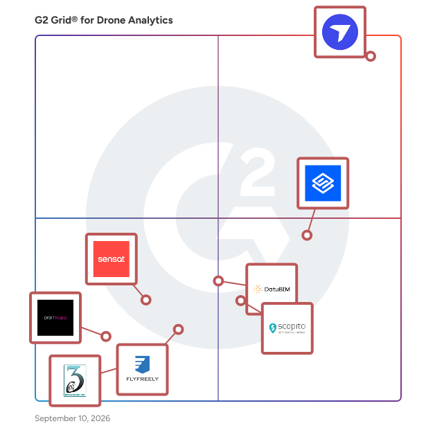
Highlighted products: DroneDeploy, Sitemark, DatuBIM, Scopito, Sensat, FlyFreely, DigitRobo, and MayaDrone.
Underlying data: [Grid® JSON](https://www.g2.com/categories/drone-analytics/grids.json?focus%5B%5D=dronedeploy&focus%5B%5D=sitemark&focus%5B%5D=datubim&focus%5B%5D=scopito&focus%5B%5D=sensat&focus%5B%5D=flyfreely&focus%5B%5D=digitrobo&focus%5B%5D=mayadrone)
TraceAir is the only 3D site work platform built specifically for builders. With powerful visibility, our software provides accurate topographic scans in a visual platform. Our white glove service offers completely turnkey coordination and seamless overnight delivery. Dead simple software makes it easy to track progress, measure stockpiles and dirt balance, check elevations and more! TraceAir empowers construction teams with accurate data so they can make better, faster decisions.
Trendspek is the leading 3D Structural Lifecycle Management Platform. Visualise built assets into high-fidelity 3D models. Conduct visual inspections from your desk with millimetre detail. Extract detailed condition insights and plan maintenance works without a site visit. Use powerful tools to analyse structural defects with exact measurements, location and specifications. View models side-by-side to observe changes. Enhance predictive maintenance by closely monitoring trends. Trendspek is trusted globally by asset owners, engineers, facility managers and contractors across leading organisations. They're protecting critical infrastructure by minimising risks, optimising workflows and proactive maintenance strategies – safely and securely in the cloud.
Average Rating: 4.5/5.0
Total Reviews: 7
AI-generated summary from verified user reviews
"Trendspek delivers Efficiency and Convenience in Defect Markups"
Rating: 4.5/5.0 stars
— Paolo A.
Rating: 4.5/5.0 stars
— Abhilash P.
The GEORIZON Viewer is a high-performance, web-based geospatial viewer designed for visualizing and exploring large datasets from mobile mapping systems, aerial surveys, drone imagery, and LiDAR sensors. The platform provides a vendor-independent environment where organizations can combine multiple geospatial data sources and interact with them directly in the browser. GEORIZON supports a wide range of data types commonly used in modern geospatial workflows, including panoramic street-level imagery, aerial imagery (nadir and oblique), drone imagery, LiDAR point clouds, textured 3D meshes, elevation models, and vector layers. These datasets can be viewed simultaneously within a single interface, allowing users to move seamlessly between ground-level imagery, aerial perspectives, and 3D spatial data. This integrated visualization makes it possible to analyze spatial environments with both photographic detail and accurate 3D geometry. A key characteristic of the GEORIZON Viewer is its vendor-independent architecture. The platform is designed to work with data from different mobile mapping systems, aerial survey providers, drone mapping platforms, and LiDAR sensors. This allows organizations to combine datasets from multiple vendors within a single viewer and prevents dependency on proprietary ecosystems. As a result, organizations retain full control over their geospatial data infrastructure. The viewer is optimized for large geospatial datasets, enabling efficient streaming of high-resolution imagery and dense LiDAR point clouds directly in the web browser. Users can navigate large areas smoothly without requiring specialized desktop GIS software. Built-in tools support measurements, spatial inspection, and interactive exploration of imagery and 3D data. GEORIZON integrates seamlessly with existing GIS platforms, CAD systems, and asset management software through APIs and standard geospatial services. This allows imagery, LiDAR, and 3D datasets to be connected to existing geospatial workflows and enterprise systems. The viewer can also be embedded in web applications or digital platforms to provide access to geospatial data across organizations. The platform plays an important role in digital twin environments, where large geospatial datasets represent real-world locations. By combining mobile mapping imagery, aerial imagery, drone data, LiDAR point clouds, and 3D models in a single viewer, GEORIZON provides a scalable visualization layer for organizations working with complex geospatial and digital twin datasets.
