Colocator
Who Is the Company Behind Colocator?
- Seller: Crowd Connected
- Year Founded: 2013
- HQ Location: Guildford, GB
-
Twitter: @crowdconnected
316 Twitter followers -
LinkedIn® Page: www.linkedin.com
12 employees on LinkedIn®
Total Products under this Category: 34
Last updated: October 21, 2026
Why You Can Trust G2's Software Rankings:
G2's software rankings are built on verified user reviews, rigorous moderation, and a consistent research methodology maintained by a team of analysts and data experts. Each product is measured using the same transparent criteria, with no paid placement or vendor influence. While reviews reflect real user experiences, which can be subjective, they offer valuable insight into how software performs in the hands of professionals. Together, these inputs power the G2 Score, a standardized way to compare tools within every category.
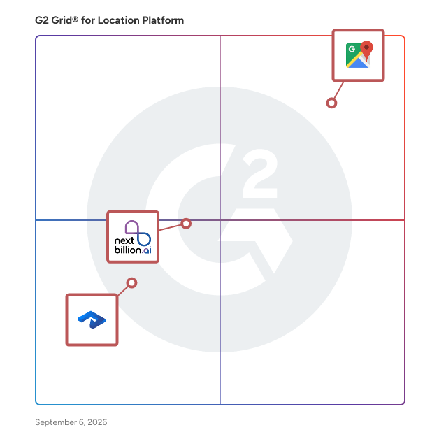
Highlighted products: Google Maps Platform, Nextbillion.ai, and Roam.ai.
Underlying data: [Grid® JSON](https://www.g2.com/categories/location-platform/grids.json?focus%5B%5D=google-maps-platform&focus%5B%5D=nextbillion_ai&focus%5B%5D=roam-ai)
EasilyGeo is an AI visibility and monitoring platform designed for brands, agencies, and SEO professionals. As search behavior shifts from traditional engines like Google to AI-powered discovery tools, EasilyGeo helps businesses understand how they are being recommended (or overlooked) by Large Language Models (LLMs).
Connect G2 to Claude or ChatGPT for answers grounded in G2's trusted reviews, comparisons, and pricing from real user insights.
Foursquare Proximity allows marketers to build custom geofences to reach consumers in real-time—without any PII data sharing required—during key moments of receptivity. Choose point-radius or polygon geofencing for highly precise location-based targeting. Filter to your exact specifications by category, chain, locality and more to boost ROI and minimize wasted ad spend. These geofences can be seamlessly integrated into your existing campaigns by deploying them directly to your programmatic advertising platform of choice.
Intelomatic Developer ships 50+ production location intelligence APIs and SDKs for geocoding, routing, geofencing, vector maps, and live tracking across Web, Android, iOS, React Native, and Flutter. It handles Indian addressing out of the box, real-road routing (distance matrices, ETA, multi-stop optimization), and live location tracking without managing your own device fleet — trusted by 100+ enterprises across banking, logistics, automotive, and field operations, processing 100M+ API calls
The platform enables to build map based marketplaces like handyman services, location-based advertising, delivery shipment solutions with an optimized route and work assignment.
Average Rating: 4.3/5.0
Total Reviews: 2
"Suite of very useful local content aggregation tools to boost local SEO and ROI"
Rating: 4.5/5.0 stars
— Bryan James C.
"Great software for eliminating supply chain issues through tracking"
Rating: 4.0/5.0 stars
— Verified User in Insurance
Maaps collects addresses and POIs to help improve delivery efficiency.
mapfwd.com simplifies location sharing by converting addresses, coordinates, or URLs into a single, universal link. Whether your recipient uses Google Maps, Apple Maps, or Waze, they can access your precise location on any device with one click. Universal Compatibility: One link works across all major navigation apps. Precision Sharing: Ideal for coordinates, meeting points, or travel planning. Effortless Interface: Designed for speed and ease, regardless of technical skill. Stop worrying about which map app your friends use—just share one link and get everyone to the right place.
Map Pro is a mapping and location visualization solution for Microsoft Teams that helps organizations display, manage, and share business locations, points of interest, routes, contacts, and events directly within Teams channels and workspaces. The solution is designed for organizations that need a centralized way to visualize geographic information, office locations, facilities, customer sites, field operations, events, or other location-based resources without leaving Microsoft Teams. Organizations use Map Pro to create shared maps that can be accessed by teams across departments and locations. Users can add points of interest, create routes between locations, and customize maps to reflect operational, logistical, or business needs. The solution supports location-based collaboration by making relevant geographic information available within the Microsoft Teams environment where employees already communicate and work. Map Pro also integrates with other business applications to provide additional context around locations. Available documentation and customer references indicate that organizations can use Map Pro alongside contact management and calendar solutions to visualize contacts on a map and display location-based events. This allows teams to better coordinate activities, identify relevant locations, and organize geographically distributed information from a single interface. The solution supports different map display formats and can be customized with business-specific locations, descriptions, routes, and categories. Teams can use Map Pro to improve visibility across offices, project sites, customer locations, workshops, service areas, and other operational environments. By centralizing location information within Microsoft Teams, organizations can reduce reliance on separate mapping applications and make location data more accessible to employees. Key capabilities include: 1. Shared map management for Microsoft Teams channels and workspaces. 2. Points of interest and route creation to visualize important business locations and travel paths. 3. Customizable map views with configurable locations, descriptions, categories, and display formats. 4. Contact visualization through integration with contact management solutions. 5. Event and calendar mapping to display location-based activities and schedules. Map Pro is intended for organizations seeking a centralized mapping solution within Microsoft Teams. By combining shared maps, business locations, contacts, routes, and event information, the solution helps teams visualize and coordinate location-based information without leaving their collaboration environment.
No Code Map App helps users build custom interactive maps from data with just a few clicks, no coding required.
