Best GIS Software - Page 28

How Many GIS Software Products Does G2 Track?

Total Products under this Category: 417

Category Stats (Sep 2026)

  • Average Rating: 4.29/5 The average rating of products in this category, based on all submitted ratings
  • Top Trending Product: Smappen (+9.51%) - Among all products in this category, Smappen recorded the largest rating increase compared to last month

Last updated: September 01, 2026

How Does G2 Rank GIS Software Products?

Why You Can Trust G2's Software Rankings:

  • 30 Analysts and Data Experts
  • 8,100+ Authentic Reviews
  • 417+ Products
  • Unbiased Rankings

G2's software rankings are built on verified user reviews, rigorous moderation, and a consistent research methodology maintained by a team of analysts and data experts. Each product is measured using the same transparent criteria, with no paid placement or vendor influence. While reviews reflect real user experiences, which can be subjective, they offer valuable insight into how software performs in the hands of professionals. Together, these inputs power the G2 Score, a standardized way to compare tools within every category.

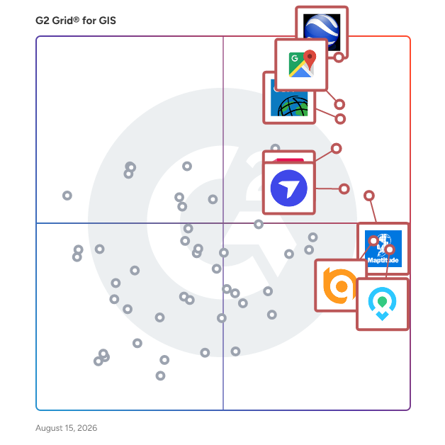
G2 Grid® for GIS Software

G2 Grid® for GIS Software plotting products by satisfaction and market presence

Highlighted products: Google Earth Pro, Google Maps Platform, Esri ArcGIS, AutoCAD, Maptitude, DroneDeploy, Mapme, and BatchGeo.

Underlying data: [Grid® JSON](https://www.g2.com/categories/gis/grids.json?focus%5B%5D=google-earth-pro&focus%5B%5D=google-maps-platform&focus%5B%5D=esri-arcgis&focus%5B%5D=autocad&focus%5B%5D=maptitude&focus%5B%5D=dronedeploy&focus%5B%5D=mapme&focus%5B%5D=batchgeo)

Ursa

Ursa Space Systems is a satellite intelligence company that provides businesses and government agencies with on-demand analytic solutions derived from a vast network of radar and optical satellites. By leveraging synthetic aperture radar technology, Ursa Space delivers real-time insights into physical changes on Earth, enabling users to monitor and analyze global events without geographic, political, or weather-related limitations. Key Features and Functionality: - Extensive Satellite Network: Manages the world's largest Virtual Constellation, comprising over 200 satellites, including SAR, optical, and radio frequency data vendors. - All-Weather Monitoring: Utilizes SAR technology to collect data in all weather conditions, day or night, ensuring continuous and reliable monitoring. - Advanced Data Fusion: Combines multiple data sources with AI-enabled processing to deliver actionable intelligence through both custom solutions and subscription services. - Rapid Insight Delivery: Significantly reduces the time to deliver insights from weeks to hours or days, enabling faster response times for time-sensitive situations like natural disasters. Primary Value and Solutions: Ursa Space addresses the challenge of accessing and interpreting complex satellite data by providing automated, scalable, and analysis-ready information. This empowers users to make informed decisions in areas such as supply chain optimization, logistics, insurance, and disaster response. By offering a comprehensive and user-friendly platform, Ursa Space enhances transparency and situational awareness, enabling organizations to monitor global events effectively and respond swiftly to emerging challenges.

Who Is the Company Behind Ursa?

  • Seller: Ursa Space
  • Year Founded: 2014
  • HQ Location: Ithaca, US
  • Twitter: @UrsaSpace
    2,308 Twitter followers
  • LinkedIn® Page: www.linkedin.com
    65 employees on LinkedIn®

Vantage Points

Who Is the Company Behind Vantage Points?

  • Seller: Esri
  • Year Founded: 1969
  • HQ Location: Redlands, CA
  • Twitter: @Esri
    188,738 Twitter followers
  • LinkedIn® Page: www.linkedin.com
    7,396 employees on LinkedIn®

Variac Geospatial

Variac GIS Geospatial is a solution that helps create a spatial map database that conforms to the specifications and requirements of your business.

Who Is the Company Behind Variac Geospatial?

Viewer for mobile mapping & aerial data GEORIZON

The GEORIZON Viewer is a high-performance, web-based geospatial viewer designed for visualizing and exploring large datasets from mobile mapping systems, aerial surveys, drone imagery, and LiDAR sensors. The platform provides a vendor-independent environment where organizations can combine multiple geospatial data sources and interact with them directly in the browser. GEORIZON supports a wide range of data types commonly used in modern geospatial workflows, including panoramic street-level imagery, aerial imagery (nadir and oblique), drone imagery, LiDAR point clouds, textured 3D meshes, elevation models, and vector layers. These datasets can be viewed simultaneously within a single interface, allowing users to move seamlessly between ground-level imagery, aerial perspectives, and 3D spatial data. This integrated visualization makes it possible to analyze spatial environments with both photographic detail and accurate 3D geometry. A key characteristic of the GEORIZON Viewer is its vendor-independent architecture. The platform is designed to work with data from different mobile mapping systems, aerial survey providers, drone mapping platforms, and LiDAR sensors. This allows organizations to combine datasets from multiple vendors within a single viewer and prevents dependency on proprietary ecosystems. As a result, organizations retain full control over their geospatial data infrastructure. The viewer is optimized for large geospatial datasets, enabling efficient streaming of high-resolution imagery and dense LiDAR point clouds directly in the web browser. Users can navigate large areas smoothly without requiring specialized desktop GIS software. Built-in tools support measurements, spatial inspection, and interactive exploration of imagery and 3D data. GEORIZON integrates seamlessly with existing GIS platforms, CAD systems, and asset management software through APIs and standard geospatial services. This allows imagery, LiDAR, and 3D datasets to be connected to existing geospatial workflows and enterprise systems. The viewer can also be embedded in web applications or digital platforms to provide access to geospatial data across organizations. The platform plays an important role in digital twin environments, where large geospatial datasets represent real-world locations. By combining mobile mapping imagery, aerial imagery, drone data, LiDAR point clouds, and 3D models in a single viewer, GEORIZON provides a scalable visualization layer for organizations working with complex geospatial and digital twin datasets.

Who Is the Company Behind Viewer for mobile mapping & aerial data GEORIZON?

vSite

Purpose-built for infrastructure projects, vSite combines AR and 3D scanning with a map-based interface that crews can see, use, and update directly on site. Unlike BIM viewers tailored for buildings, vSite is designed for large-scale public works like highways, airports, and utility networks. The platform unifies AR visualization, mobile scanning, and a centralized web portal into one workflow, turning designs and as-builts into clear, geo-referenced records. By bridging field capture with office collaboration, vSite makes project data accessible, reliable, and ready for decision-making at every stage of delivery.

Who Is the Company Behind vSite?

  • Seller: vGIS
  • Year Founded: 2017
  • HQ Location: Toronto, CA
  • LinkedIn® Page: www.linkedin.com
    30 employees on LinkedIn®

Web GIS-Interactive Online Platform

Earth polis provides users with online access to geographic data at any time and from anywhere, allowing immediate imaging, analysis, and querying on them.

Who Is the Company Behind Web GIS-Interactive Online Platform?

WebPano

Who Is the Company Behind WebPano?

  • Seller: 3Deling
  • Year Founded: 2007
  • HQ Location: Krakow, PL
  • LinkedIn® Page: www.linkedin.com
    37 employees on LinkedIn®

WIGeoWeb

Who Is the Company Behind WIGeoWeb?

XMap

Who Is the Company Behind XMap?

  • Seller: Garmin
  • Year Founded: 1989
  • HQ Location: N/A
  • LinkedIn® Page: www.linkedin.com
    15 employees on LinkedIn®
Daniel Rivera
DR
Researched and written by Daniel Rivera
Updated March 4, 2025