Top Free GIS Software - Page 3

How Many GIS Software Products Does G2 Track?

Total Products under this Category: 415

Category Stats (Sep 2026)

  • Average Rating: 4.29/5 The average rating of products in this category, based on all submitted ratings
  • Top Trending Product: Smappen (+9.51%) - Among all products in this category, Smappen recorded the largest rating increase compared to last month

Last updated: September 01, 2026

How Does G2 Rank GIS Software Products?

Why You Can Trust G2's Software Rankings:

  • 30 Analysts and Data Experts
  • 8,100+ Authentic Reviews
  • 415+ Products
  • Unbiased Rankings

G2's software rankings are built on verified user reviews, rigorous moderation, and a consistent research methodology maintained by a team of analysts and data experts. Each product is measured using the same transparent criteria, with no paid placement or vendor influence. While reviews reflect real user experiences, which can be subjective, they offer valuable insight into how software performs in the hands of professionals. Together, these inputs power the G2 Score, a standardized way to compare tools within every category.

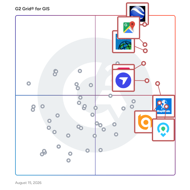
G2 Grid® for GIS Software

G2 Grid® for GIS Software plotting products by satisfaction and market presence

Highlighted products: Google Earth Pro, Google Maps Platform, Esri ArcGIS, AutoCAD, Maptitude, DroneDeploy, Mapme, and BatchGeo.

Underlying data: [Grid® JSON](https://www.g2.com/categories/gis/grids.json?focus%5B%5D=google-earth-pro&focus%5B%5D=google-maps-platform&focus%5B%5D=esri-arcgis&focus%5B%5D=autocad&focus%5B%5D=maptitude&focus%5B%5D=dronedeploy&focus%5B%5D=mapme&focus%5B%5D=batchgeo)

Mappedin

Mappedin is a global leader in indoor mapping and spatial data management. Our solutions power billions of square feet of indoor space and guide millions of people visiting malls, stadiums, airports, offices, healthcare facilities, warehouses, universities, and more. We're making maps as powerful indoors as they are outdoors. With custom enterprise solutions, easy-to-use developer tools, and a revolutionary self-service mapmaking platform, we enable our customers to enhance indoor experiences, optimize spaces, track assets, and ensure public safety with AI-powered mapping technology. Mappedin offers an intuitive platform unmatched in flexibility and scalability, allowing organizations of all sizes to create, manage, and deploy interactive indoor maps without specialized technical expertise. Secure cloud-based infrastructure ensures real-time updates across all touchpoints, maintaining wayfinding accuracy even as spaces evolve. What sets Mappedin apart is a commitment to ease of integration. Mappedin SDK supports seamless embedding into existing applications, websites, and kiosks, while an open API architecture enables custom functionality and third-party system integration. With enterprise-grade security, comprehensive analytics, and dedicated customer support, Mappedin delivers a complete indoor mapping solution that transforms how people navigate and interact with complex indoor environments. Join thousands of satisfied customers worldwide who trust Mappedin to power their indoor mapping and navigation needs with industry-leading technology that's intuitive, reliable, and continuously evolving to meet tomorrow's spatial challenges.

Average Rating: 4.5/5.0

Total Reviews: 5

How Do G2 Users Rate Mappedin?

  • Ease of Use: 7.9/10 (Category avg: 8.4/10)

Who Is the Company Behind Mappedin?

  • Seller: Mappedin
  • Year Founded: 2011
  • HQ Location: Waterloo, CA
  • Twitter: @mappedin
    1,338 Twitter followers
  • LinkedIn® Page: ca.linkedin.com
    97 employees on LinkedIn®

Who Uses This Product?

  • Company Size: 80% Small, 20% Medium

What Do G2 Reviewers Say About Mappedin?

AI-generated summary from verified user reviews

Pros
  • Users appreciate the 3D visualization features of MappedIn, enhancing experiences for both exhibitors and customers alike.
  • Users appreciate the API integration of Mappedin, allowing effective data collection and analysis across various sectors.
  • Users value the innovative 3D mapping and data visualization features, enhancing experiences across various sectors.
  • Users praise the design quality of Mappedin for its user-friendly and precise mapping capabilities.
  • Users find Mappedin's ease of use exceptional, making mapping accessible for all, including less experienced users.
Cons
  • Users face ongoing issues with reporting and analytics, which hinder effective data management and impact overall user experience.
  • Users experience inaccuracy in space analysis, leading to miscalculations of added widgets and frustrating outcomes.
  • Users face challenges with poor reporting and analytics, affecting data-driven decision-making and overall user experience.

What Are Recent G2 Reviews of Mappedin?

Birdi

Birdi is the geospatial AI workspace your whole team can talk to — built for construction, mining, utilities and infrastructure teams. Describe what you need from your site data in plain language — create a map, measure an area, detect features, build a report — and Scout, Birdi's built-in AI agent, walks you through it step by step. No GIS training, no waiting on a specialist. Bring in data from any source: fly your own drone, book Birdi capture, connect docking stations, or upload data you've already processed. Birdi handles GeoTIFFs, orthomosaics, digital elevation models, point clouds, vectors, DXF and 3D models in any coordinate system — no proprietary hardware required. Share view-only links so contractors, clients and stakeholders can see the map without needing a paid seat. Roles and permissions keep access controlled, and comments live right on the map, in context. Teams use Birdi to track site progress, verify stockpile and earthwork volumes, inspect assets and vegetation, monitor change over time, and produce reports for compliance and records. Used in 90+ countries. ISO 9001 and ISO 27001 certified.

Average Rating: 4.9/5.0

Total Reviews: 4

How Do G2 Users Rate Birdi?

  • Data Capture: 9.2/10 (Category avg: 8.6/10)
  • Data Visualization: 8.3/10 (Category avg: 8.6/10)
  • Ease of Use: 9.4/10 (Category avg: 8.4/10)
  • Spatial Analysis: 9.2/10 (Category avg: 8.4/10)

Who Is the Company Behind Birdi?

  • Seller: Birdi
  • Year Founded: 2017
  • HQ Location: Sydney, AU
  • LinkedIn® Page: www.linkedin.com
    15 employees on LinkedIn®

Who Uses This Product?

  • Company Size: 100% Small

What Do G2 Reviewers Say About Birdi?

AI-generated summary from verified user reviews

Pros
  • Users value the smooth collaboration communication with Birdi, enhancing interaction and transparency between teams and clients.
  • Users value the smooth communication offered by Birdi, enhancing collaboration and transparency in project management.
  • Users appreciate the ease of use of Birdi, enhancing collaboration and communication in project tracking.
  • Users find that Birdi offers seamless image integration for monitoring projects and enhancing team-client communication.
  • Users find Birdi to greatly enhance team-client interaction, simplifying project monitoring and communication significantly.
Cons
  • Users find the price of Birdi to be high, suggesting it could be more affordable for smaller teams.
  • Users feel the high cost of Birdi limits accessibility for small teams and independent professionals seeking affordable options.
  • Users find the pricing issues of Birdi to be a significant drawback, limiting access for smaller teams.

What Are Recent G2 Reviews of Birdi?

Huwise

Huwise is a SaaS data product marketplace developed by a French company based in Paris, with over 15 years of experience. Recognized as a leading European player in data marketplace solutions by independent analyst firms, Huwise powers more than 3,000 data marketplaces across 25 countries. The platform is widely adopted across key industries including Banking & Insurance, Utilities and Energy, Transportation, Retail, Manufacturing and Central & Local Government. Huwise is a leading data product marketplace designed to transform raw data into AI-ready, business-ready data products. Unlike traditional data catalogs that primarily focus on metadata management and data discovery, Huwise actively drives data usage across organizations by converting data into actionable products. The platform is designed for business users, data product owners, data teams, and AI agents, providing a self-service, e-commerce-like experience that makes data more accessible, understandable, and usable across the organization. By enabling secure, governed, and scalable access to trusted data products, Huwise helps Chief Data Officers (CDOs) and Chief Data & AI Officers (CDAIOs) accelerate their data governance strategy, increase data adoption, and maximize the business impact of data and AI initiatives. Targeted at organizations seeking to enhance their data utilization, Huwise stands apart from conventional data platforms such as data lakes and cloud data warehouses. While these technologies are primarily focused on storing and processing large volumes of raw data, Huwise operates on top of the data stack to activate and distribute data. It ensures that data is not only understandable but also governed and directly usable throughout the organization. By complementing existing data catalog solutions, Huwise offers a business-facing access layer that integrates with raw, curated and certified data products, leveraging existing metadata and governance frameworks. The platform is built on data product principles, enabling organizations to publish and manage trusted, ready-to-use data products. Huwise facilitates self-service access to data without the need for technical expertise, ensuring that governance, security, and traceability are maintained across all data usage. Furthermore, it promotes data adoption through collaboration, feedback, and usage analytics, which are essential for driving engagement and maximizing the value of data within the organization. Huwise accelerates AI and analytics use cases by providing high-quality, contextualized data that enhances decision-making processes. Huwise also plays a crucial role in modern data architectures by supporting both the semantic layer and the emerging context layer. The semantic layer standardizes data definitions into business-friendly terms, while the context layer enriches this foundation with usage intelligence, lineage, governance, and real business interactions. This dual-layer approach enables both humans and AI to interpret and trust data accurately, reducing risks associated with misinterpretation or bias. As organizations increasingly adopt data mesh, data product strategies, and AI-driven operations, Huwise offers a modern approach for data sharing that is dedicated to drive data value and enhance business performance. It offers a data marketplace platform that not only organizes data but also activates it to deliver measurable business value. For companies aiming to maximize the potential of their data ecosystem, Huwise provides a future-proof, interoperable layer that bridges storage, governance, and consumption, ultimately accelerating data adoption and AI success at scale.

Average Rating: 4.7/5.0

Total Reviews: 11

How Do G2 Users Rate Huwise?

  • Data Capture: 10.0/10 (Category avg: 8.6/10)
  • Data Visualization: 10.0/10 (Category avg: 8.6/10)
  • Ease of Use: 9.4/10 (Category avg: 8.4/10)
  • Spatial Analysis: 9.2/10 (Category avg: 8.4/10)

Who Is the Company Behind Huwise?

  • Seller: Huwise
  • Company Website:
  • Year Founded: 2011
  • HQ Location: Paris, FR
  • LinkedIn® Page: www.linkedin.com
    105 employees on LinkedIn®

Who Uses This Product?

  • Top Industries: Government Administration
  • Company Size: 64% Large, 36% Medium

What Do G2 Reviewers Say About Huwise?

AI-generated summary from verified user reviews

Pros
  • Users value the ease of use of Huwise, highlighting its intuitive interface and quick implementation process.
  • Users praise the intuitive interface of Huwise, making it easy to create appealing designs and upload data efficiently.
  • Users value the flexible access control of Huwise, facilitating both open and limited access with ease.
  • Users enjoy the easy accessibility of Huwise, enabling quick data uploads and creating appealing interfaces effortlessly.
  • Users value the effective collaboration communication within Huwise, benefiting from accessible teams and community engagement.
Cons
  • Users face complexity issues due to limitations in visualization and coding capabilities with Huwise.
  • Users face data limitations with Huwise, including restrictions on using multiple datasets in visualizations.
  • Users face feature limitations with Huwise, especially in using multiple datasets for visualizations.
  • Users are concerned about the high cost of Huwise, citing rising prices and complex pricing models.
  • Users face integration issues with Huwise, such as limitations on combining multiple datasets in visualizations.

What Are Recent G2 Reviews of Huwise?

Maptitude Online

Maptitude Online is a cloud-based business mapping and geographic information system (GIS) software that lets organizations create, analyze, and share interactive maps in any web browser, with geographic and demographic data included in the subscription. Built by Caliper, a GIS software company with more than 40 years of experience, Maptitude Online is made for everyday business users, not developers or GIS specialists. If your team works with customer lists, sales territories, or location data in spreadsheets, Maptitude Online turns that data into clear, interactive maps without any technical setup or special training. No other software is required. Users can upload Excel/CSV files directly from their browser, map the data instantly using the step-by-step Create-a-Map Wizard, and share the results publicly or privately. It is used across industries including retail, healthcare, real estate, banking, and franchising by sales analysts, territory managers, marketing teams, operations planners, and site selection teams. The subscription includes current street, postal boundary, and Census demographic data, so users do not need to find or pay for geographic data separately. What Maptitude Online does: • Territory management: Build and balance sales/service territories from ZIP Codes, counties, states, or Census tracts, with unlimited territory creation*, and tools that automatically find gaps and problem areas. • Data visualization: Heat, cluster, bubble, pie/bar chart, and color map themes built directly from your spreadsheet data, plus drive-time rings around multiple locations simultaneously at up to 10 hours of travel time, far beyond what most competing platforms offer. Unlimited drive-time rings*. • Route optimization: Plan and optimize routes with an unlimited number of routes* and 100 stops per route, more than most business mapping tools support. • Geocoding: Drop any list of addresses, postal codes, or city names onto a map. Unlimited addresses can be geocoded*. • Demographic data: Layer Census population, income, age, and other statistics on your maps to understand where your customers are. • Map sharing: Share publicly or privately, on any device, with full control over who sees what, including administrator controls to manage publishing across an entire organization. No limit on the number of maps you can create*. • Uptime: 99.9% (2025) • Price: $795, a fraction of competing GIS prices. A 30-day free trial (no credit card) is available. • Support: Well-supported and well-documented with G2 verified reviews from real users telling the story: Quality of Support = 91%; Ease of Doing Business With = 94%; both well above the GIS category average. There is also a full library of tutorials, videos, and written guides kept continuously up to date, plus an AI-powered support assistant available any time of day. • WebGL: Maps stay fast and smooth regardless of how many locations you add. No performance degradation at any dataset size. • AI-powered "Get Data" wizard (coming 2026): Type a plain-English query to automatically find and map demographic data. • Google Sheets Support (coming 2026). * Unlimited up to the 10GB storage per account

Average Rating: 5.0/5.0

Total Reviews: 3

How Do G2 Users Rate Maptitude Online?

  • Data Capture: 10.0/10 (Category avg: 8.6/10)
  • Data Visualization: 10.0/10 (Category avg: 8.6/10)
  • Ease of Use: 9.4/10 (Category avg: 8.4/10)
  • Spatial Analysis: 10.0/10 (Category avg: 8.4/10)

Who Is the Company Behind Maptitude Online?

  • Seller: Caliper
  • Year Founded: 1983
  • HQ Location: Newton, MA
  • Twitter: @Maptitude
    1,195 Twitter followers
  • LinkedIn® Page: www.linkedin.com
    40 employees on LinkedIn®

Who Uses This Product?

  • Company Size: 67% Small, 33% Medium

What Are Recent G2 Reviews of Maptitude Online?

Easy Trace Pro

Easy Trace Pro is a powerful tool for map creation, from scanned image or imagery up to GIS-ready data. Efficient image preprocessing, automatic, semiautomatic and manual tools for line tracing, creation of points and polygons, symbol and text recognition, topology check up and correction, convinient tools for attributing, map navigation and inspection - these are just some features of Easy Trace. The latest version has built-in technology examples and a powerful technology-building tool.

Average Rating: 4.8/5.0

Total Reviews: 2

How Do G2 Users Rate Easy Trace Pro?

  • Data Capture: 8.3/10 (Category avg: 8.6/10)
  • Data Visualization: 10.0/10 (Category avg: 8.6/10)
  • Ease of Use: 7.5/10 (Category avg: 8.4/10)
  • Spatial Analysis: 10.0/10 (Category avg: 8.4/10)

Who Is the Company Behind Easy Trace Pro?

Who Uses This Product?

  • Company Size: 100% Small

What Do G2 Reviewers Say About Easy Trace Pro?

AI-generated summary from verified user reviews

Pros
  • Users find Easy Trace Pro's ease of use invaluable for quickly creating GIS-compatible data from scanned maps.
  • Users appreciate the GIS tools in Easy Trace Pro, simplifying data production from scanned maps and images.
  • Users commend the variety of tools in Easy Trace Pro, enhancing GIS data production from scanned images.
Cons
  • Users face inaccuracy issues with Easy Trace Pro, especially with complex maps and low-resolution images needing manual corrections.
  • Users experience inaccuracy issues with Easy Trace Pro, especially for complex maps and low-resolution images, needing manual correction.
  • Users find that manual input can be inaccurate, necessitating extensive cleanup for effective use in GIS applications.
  • Users face challenges with mapping inaccuracies, particularly with complex maps and low-resolution images requiring manual adjustments.

What Are Recent G2 Reviews of Easy Trace Pro?

What Are G2 Users Discussing About Easy Trace Pro?

netTerrain OSP

From street-to-strand zoomable views to capacity insights and circuits, netTerrain OSP deciphers your fiber and turns it into into insights you can act on. netTerrain OSP gives you the ability to see anything in your fiber plant in seconds: easily zoom down from street views to strand views with GIS-mapping, inventory, and analytics capabilities. Plan your fiber capacity with precision: get cable and strand insights at your fingertips with an up-to-date inventory using software that’s made for OSP pros like you. Circuit deployment and management woes? Make circuit design and allocation easy and fun: automated circuit routing algorithms and circuit layout records replace the pain of spreadsheets and manual tracking. Flexible licensing options (from on premise to cloud) designed to suit all budgets are offered.

Average Rating: 3.3/5.0

Total Reviews: 2

How Do G2 Users Rate netTerrain OSP?

  • Data Capture: 8.3/10 (Category avg: 8.6/10)
  • Data Visualization: 7.5/10 (Category avg: 8.6/10)
  • Ease of Use: 9.2/10 (Category avg: 8.4/10)
  • Spatial Analysis: 6.7/10 (Category avg: 8.4/10)

Who Is the Company Behind netTerrain OSP?

  • Seller: Graphical Networks
  • Year Founded: 2007
  • HQ Location: Gaithersburg, US
  • Twitter: @netterrain
    1,240 Twitter followers
  • LinkedIn® Page: www.linkedin.com
    21 employees on LinkedIn®

Who Uses This Product?

  • Company Size: 50% Medium, 50% Small

Simple GIS Software

Easy to use GIS software for Windows desktop, laptop, and tablet computers at the lowest price. Create, analyze, and publish spatial data. Many vector editing features plus data wizards to access freely available data from the USGS, US Census Bureau, and OpenStreetMap. Also supports, GPS tracking, geocoding, routing, and navigation. Easily map your addresses from Excel spreadsheets or csv files. Highly customizable via integrated VB editor with access to hundreds of properties and methods.

Average Rating: 5.0/5.0

Total Reviews: 2

How Do G2 Users Rate Simple GIS Software?

  • Data Capture: 10.0/10 (Category avg: 8.6/10)
  • Data Visualization: 10.0/10 (Category avg: 8.6/10)
  • Ease of Use: 10.0/10 (Category avg: 8.4/10)
  • Spatial Analysis: 10.0/10 (Category avg: 8.4/10)

Who Is the Company Behind Simple GIS Software?

Who Uses This Product?

  • Company Size: 100% Medium

What Are Recent G2 Reviews of Simple GIS Software?

Vectorworks Landmark

Transform your design, modeling, and presentation workflows with Vectorworks Landmark, the industry-leading landscape-focused BIM software solution made specifically for landscape architects and designers. With intelligent objects, powerful databases, and flexible documentation features, Landmark streamlines integrated 2D and 3D landscape-specific sustainable BIM workflows all in one application.

Average Rating: 4.4/5.0

Total Reviews: 66

How Do G2 Users Rate Vectorworks Landmark?

  • Data Capture: 7.9/10 (Category avg: 8.6/10)
  • Data Visualization: 7.5/10 (Category avg: 8.6/10)
  • Ease of Use: 7.1/10 (Category avg: 8.4/10)
  • Spatial Analysis: 6.1/10 (Category avg: 8.4/10)

Who Is the Company Behind Vectorworks Landmark?

  • Seller: Vectorworks, Inc.
  • Company Website:
  • Year Founded: 1985
  • HQ Location: Columbia, Maryland
  • Twitter: @Vectorworks
    10,997 Twitter followers
  • LinkedIn® Page: www.linkedin.com
    321 employees on LinkedIn®

Who Uses This Product?

  • Who Uses This: Landscape Architect, Owner
  • Top Industries: Architecture & Planning, Design
  • Company Size: 76% Small, 15% Medium

What Do G2 Reviewers Say About Vectorworks Landmark?

AI-generated summary from verified user reviews

Pros
  • Users praise the ease of use of Vectorworks Landmark, appreciating its templates, library, and powerful rendering capabilities.
  • Users rave about the impressive 3D visualization capabilities of Vectorworks Landmark, enhancing design and presentation quality significantly.
  • Users appreciate the powerful drawing capabilities of Vectorworks Landmark, enhancing both illustrative and construction plan production.
  • Users value the versatile parametric/BIM tools in Vectorworks Landmark, enhancing their design capabilities with integrated workflows.
  • Users value the integrated planting and modeling tools of Vectorworks Landmark, enhancing their design and workflow efficiency.
Cons
  • Users face a steep learning curve with Vectorworks Landmark, making initial use and mastering features challenging.
  • Users find the difficult learning curve of Vectorworks Landmark to be a significant obstacle for beginners.
  • Users find poor usability in Vectorworks Landmark due to unclear information and difficulties in file sharing.
  • Users find the steep learning curve daunting, as mastering Vectorworks Landmark's depth takes significant time and effort.
  • Users express frustration with the inadequate tools in Vectorworks Landmark, citing difficulties with 3D modeling and text formatting.

What Are Recent G2 Reviews of Vectorworks Landmark?

What Are G2 Users Discussing About Vectorworks Landmark?

CMaps Analytics

CMaps Analytics is a cloud geo-analysis suite which includes a browser-based Designer and JavaScript API. Together, with your cloud map service of choice (Google Maps, MapBox, HERE, ESRI, Carto), CMaps Analytics provides rapid creation of geospatial analysis without any server software or specialized skills required. Create drillable regional views, drive-time analysis and other visualizations. CMaps Analytics includes over 20 map visualization types, hundreds of clickable properties, and a growing geo-analysis widget library to analyze, search, filter, rank and understand geospatial relationships. Embed CMaps Analytics into any software solution or use our native integration kits into platforms like SAP.

Average Rating: 4.0/5.0

Total Reviews: 1

How Do G2 Users Rate CMaps Analytics?

  • Data Capture: 10.0/10 (Category avg: 8.6/10)
  • Data Visualization: 6.7/10 (Category avg: 8.6/10)
  • Ease of Use: 6.7/10 (Category avg: 8.4/10)
  • Spatial Analysis: 10.0/10 (Category avg: 8.4/10)

Who Is the Company Behind CMaps Analytics?

Who Uses This Product?

  • Company Size: 100% Small

What Are Recent G2 Reviews of CMaps Analytics?

Coreo

Coreo by Natural Apptitude is a powerful and user-friendly data collection platform designed for ecologists, environmental professionals and conservation organisations. Streamline your ecological surveys and environmental monitoring with Coreo's intuitive mobile app and online platform. Key Features: • UKHab & BNG Platform: Streamline UKHab survey work and BNG assessments. • Pre-built survey templates: Includes templates for protected species and the ability to create custom surveys from scratch. • Offline functionality: Collect data in the field even without internet access. • Real-time collaboration: Standardise data collection and collaborate seamlessly with your team. • Data management: Easily manage, analyse, and export your data. Coreo is designed to: • Save you time and improve accuracy. • Eliminate errors and time wasted transcribing data from paper. • Simplify complex surveys. • Enhance collaboration and standardise data collection. What our customers think of Coreo: • "Coreo and the UKHab Survey App have increased habitat survey efficiency by around 65%." Shannon Brady - Senior Biodiversity Net Gain Consultant at Urban Green • "I love Coreo! It's so flexible and easy to use. The greatest benefit for me is Coreo's data management – everything is collated and I can filter the data in any way." Heather Dickie - Programme Manager at Bore Place About Natural Apptitude: Natural Apptitude is a UK-based software company founded in 2013. We are passionate about the environment and doing our part to tackle the many challenges facing the natural world. Natural Apptitude also specializes in developing bespoke apps tailored to specific ecological needs like INNS Mapper and Big Butterfly Count. Learn more about how Coreo can transform your ecological data collection https://coreo.io/

Average Rating: 4.7/5.0

Total Reviews: 3

How Do G2 Users Rate Coreo?

  • Data Capture: 10.0/10 (Category avg: 8.6/10)
  • Data Visualization: 10.0/10 (Category avg: 8.6/10)
  • Ease of Use: 8.3/10 (Category avg: 8.4/10)
  • Spatial Analysis: 8.3/10 (Category avg: 8.4/10)

Who Is the Company Behind Coreo?

Who Uses This Product?

  • Company Size: 67% Small, 33% Medium

What Do G2 Reviewers Say About Coreo?

AI-generated summary from verified user reviews

Pros
  • Users find Coreo to be a very user-friendly software, with easy setup and excellent survey functionality.
  • Users value the easy integration of Coreo, finding it user-friendly for data collection and management.
  • Users value the easy setup of Coreo, enabling quick and effective data collection through various platforms.
  • Users praise Coreo for its user-friendly functionality, making data collection and survey management effortless and efficient.
  • Users find Coreo to be a very user-friendly software, making data collection and surveys effortless and efficient.
Cons
  • Users find the missing features in Coreo could enhance usability, particularly in data export options.
  • Users desire improvements in exporting data, preferably avoiding reliance on Excel for better usability.
  • Users find the limited features of Coreo, such as export options, could be improved for a better experience.

What Are Recent G2 Reviews of Coreo?

Extensis GeoExpress

Your Go-To Image Compression and Manipulation Software — Now for Raster and LiDAR Pixels add up. Save space and storage costs by reducing the size of your geospatial data Compress raster imagery to MrSID, JPEG 2000 and NITF formats, or compress LiDAR data to MrSID and LAZ formats. Then, optimize your imagery with powerful tools for mosaicking, reprojection, and more.

Average Rating: 4.5/5.0

Total Reviews: 1

How Do G2 Users Rate Extensis GeoExpress?

  • Ease of Use: 10.0/10 (Category avg: 8.4/10)

Who Is the Company Behind Extensis GeoExpress?

  • Seller: Extensis
  • Year Founded: 1993
  • HQ Location: Portland, OR
  • Twitter: @extensis
    5,240 Twitter followers
  • LinkedIn® Page: www.linkedin.com
    57 employees on LinkedIn®
  • Phone: 800-796-9798

Who Uses This Product?

  • Company Size: 100% Medium

What Are Recent G2 Reviews of Extensis GeoExpress?

What Are G2 Users Discussing About Extensis GeoExpress?

GeoTAX

Remove the guesswork in tax jurisdiction assignments by identifying accurate local tax rates instantly. Learn more at: https://www.precisely.com/product/precisely-spectrum-geocoding/spectrum-enterprise-tax

Average Rating: 4.0/5.0

Total Reviews: 1

How Do G2 Users Rate GeoTAX?

  • Data Visualization: 10.0/10 (Category avg: 8.6/10)
  • Ease of Use: 10.0/10 (Category avg: 8.4/10)

Who Is the Company Behind GeoTAX?

  • Seller: Precisely
  • HQ Location: Burlington, Massachusetts
  • Twitter: @PreciselyData
    3,963 Twitter followers
  • LinkedIn® Page: www.linkedin.com
    3,046 employees on LinkedIn®

Who Uses This Product?

  • Company Size: 100% Small

What Are Recent G2 Reviews of GeoTAX?

What Are G2 Users Discussing About GeoTAX?

MangoMap

Make Amazing Interactive Web Maps That You and Your Users Will Love!

Average Rating: 4.5/5.0

Total Reviews: 1

How Do G2 Users Rate MangoMap?

  • Ease of Use: 10.0/10 (Category avg: 8.4/10)

Who Is the Company Behind MangoMap?

  • Seller: Mangomap
  • Year Founded: 2012
  • HQ Location: Bristol, GB
  • LinkedIn® Page: www.linkedin.com
    6 employees on LinkedIn®

Who Uses This Product?

  • Company Size: 100% Medium

What Are Recent G2 Reviews of MangoMap?

Mapflow

Mapflow is an analytics & mapping AI-processing platform that provides ready-to-use ML models and instant access to major global satellite imagery providers.

Average Rating: 5.0/5.0

Total Reviews: 1

How Do G2 Users Rate Mapflow?

  • Data Capture: 10.0/10 (Category avg: 8.6/10)
  • Data Visualization: 10.0/10 (Category avg: 8.6/10)
  • Ease of Use: 10.0/10 (Category avg: 8.4/10)

Who Is the Company Behind Mapflow?

  • Seller: GeoAlert
  • Year Founded: 2019
  • HQ Location: Wilmington, US
  • LinkedIn® Page: linkedin.com
    10 employees on LinkedIn®

Who Uses This Product?

  • Company Size: 100% Small

What Are Recent G2 Reviews of Mapflow?

MapZot.AI

MapZot.AI is an advanced AI-powered site selection and predictive analytics platform designed to help retailers, commercial real estate professionals, and urban planners make smarter location decisions. Based in Atlanta, GA, our mission is to eliminate guesswork in real estate site selection by combining mobility data, traffic forecasting, and revenue prediction models into one easy-to-use software solution. With MapZot.AI, businesses gain access to real-time predictive traffic analytics and AI-driven mobility insights that uncover where customers are moving, shopping, and engaging across urban and suburban markets. Our flagship tools, such as Traffic-Rx, Revenue Forecasting, White Space Analysis, and GIS Mapping, empower decision-makers to identify growth opportunities, forecast demand, and optimize retail expansion strategies with confidence. Unlike traditional site selection tools, MapZot.AI leverages machine learning algorithms, behavioral mobility data, and geospatial intelligence to deliver forward-looking insights — not just historical patterns. This makes our platform especially valuable for companies navigating shifting consumer behaviors, evolving urban landscapes, and competitive retail environments. Key benefits include: Predictive Site Selection Software for retail and commercial real estate. Traffic Forecasting AI to project customer flow by time, location, and scenario. Mobility Heatmaps & GIS Mapping to visualize demand across trade areas. Revenue Forecasting Models tailored to specific industries and geographies. White Space Analysis Tools to identify untapped opportunities. Trusted by real estate developers, retailers, franchise operators, and city planners, MapZot.AI has been recognized for accuracy, speed, and scalability. Our platform is optimized for mobile-first, cloud-based access, ensuring seamless integration into business workflows. Whether you are a retail brand planning your next store in Atlanta, a commercial real estate investor evaluating urban corridors, or a consultant providing strategic advisory services, MapZot.AI provides the data-driven clarity you need to make high-stakes location decisions in 2025 and beyond. At MapZot.AI, we believe the future of site selection is predictive, transparent, and powered by AI.

Average Rating: 5.0/5.0

Total Reviews: 2

How Do G2 Users Rate MapZot.AI?

  • Ease of Use: 10.0/10 (Category avg: 8.4/10)

Who Is the Company Behind MapZot.AI?

  • Seller: Mapzot.AI
  • Year Founded: 2018
  • HQ Location: Greater Atlanta Area , US
  • Twitter: @mapzot
    54 Twitter followers
  • LinkedIn® Page: www.linkedin.com
    19 employees on LinkedIn®

Who Uses This Product?

  • Company Size: 100% Small

What Are Recent G2 Reviews of MapZot.AI?