Best Location Intelligence Software - Page 18

How Many Location Intelligence Software Products Does G2 Track?

Total Products under this Category: 302

Category Stats (Sep 2026)

  • Average Rating: 4.4/5 (↑0.01 vs Aug 2026) The average rating of products in this category, based on all submitted ratings
  • Top Trending Product: Smappen (+9.51%) - Among all products in this category, Smappen recorded the largest rating increase compared to last month

Last updated: September 01, 2026

How Does G2 Rank Location Intelligence Software Products?

Why You Can Trust G2's Software Rankings:

  • 30 Analysts and Data Experts
  • 36,800+ Authentic Reviews
  • 302+ Products
  • Unbiased Rankings

G2's software rankings are built on verified user reviews, rigorous moderation, and a consistent research methodology maintained by a team of analysts and data experts. Each product is measured using the same transparent criteria, with no paid placement or vendor influence. While reviews reflect real user experiences, which can be subjective, they offer valuable insight into how software performs in the hands of professionals. Together, these inputs power the G2 Score, a standardized way to compare tools within every category.

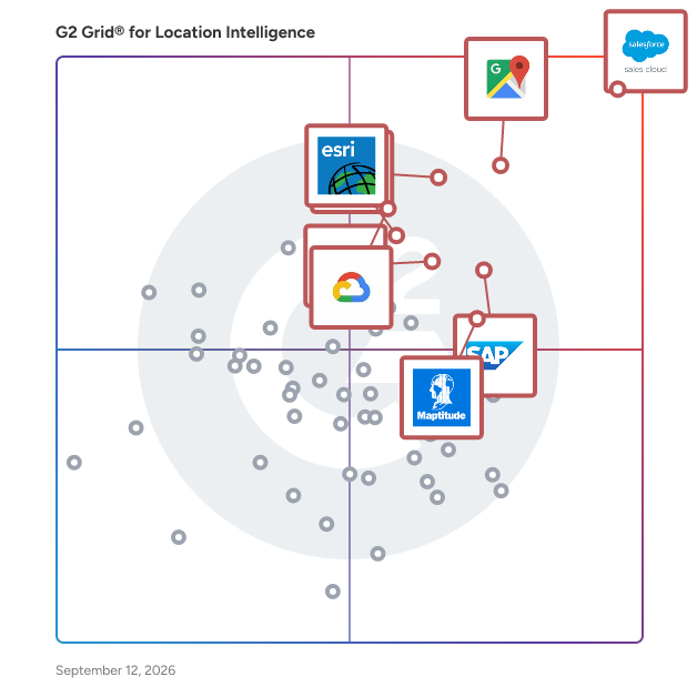
G2 Grid® for Location Intelligence Software

G2 Grid® for Location Intelligence Software plotting products by satisfaction and market presence

Highlighted products: Agentforce Sales (formerly Salesforce Sales Cloud), Google Maps Platform, Tableau, SAP HANA Cloud, Google Earth Engine, Alteryx, Esri ArcGIS, and Maptitude.

Underlying data: [Grid® JSON](https://www.g2.com/categories/location-intelligence/grids.json?focus%5B%5D=agentforce-sales-formerly-salesforce-sales-cloud&focus%5B%5D=google-maps-platform&focus%5B%5D=tableau&focus%5B%5D=sap-hana-cloud-2025-10-01&focus%5B%5D=google-earth-engine&focus%5B%5D=alteryx&focus%5B%5D=esri-arcgis&focus%5B%5D=maptitude)

Maptaskr Power Maps

Maptaskr Power Maps is an enterprise geospatial solution for Microsoft Dynamics 365, Power Apps, and Power Pages that enables organizations to embed location intelligence directly into their business processes. Many organizations already maintain valuable location-based information across CRM, ERP, asset management, GIS, and operational systems. Power Maps brings this information together within the Microsoft Power Platform, allowing users to visualize, analyze, and act on business and geospatial data without leaving the applications they use every day. The platform provides interactive mapping, geospatial authoring, spatial search, routing, filtering, layer management, location-based analysis, and enterprise GIS integration capabilities. Users can view customers, assets, projects, stakeholders, infrastructure, land parcels, operational activities, and GIS datasets within a unified mapping experience, helping teams understand geographic relationships and make better-informed decisions. Power Maps integrates with Microsoft Dataverse, Dynamics 365, ArcGIS Online, ArcGIS Enterprise, Azure Maps, and other enterprise GIS services. Organizations can combine authoritative GIS information with operational business data to support map-driven workflows across planning, operations, engagement, compliance, and reporting activities. The platform supports a wide range of use cases including stakeholder management, asset management, field operations, land access and approvals, environmental management, infrastructure planning, inspections, customer engagement, emergency management, and operational risk assessment. Business users can interact with maps, spatial data, and GIS services directly within familiar Microsoft applications, reducing reliance on specialist GIS tools for day-to-day operational activities. Power Maps is used by organizations across government, utilities, mining, energy, transportation, infrastructure, environmental, and public sector industries to bring geographic context into business workflows and improve operational visibility. By connecting business data and location intelligence in a single operational experience, organizations can better understand what is happening, where it is happening, and what actions need to be taken.

Who Is the Company Behind Maptaskr Power Maps?

Mapular CA

Who Is the Company Behind Mapular CA?

  • Seller: Mapular
  • Year Founded: 2023
  • HQ Location: Berlin, DE
  • LinkedIn® Page: www.linkedin.com
    11 employees on LinkedIn®

Mapular Consumer Analytics

Smarter Consumer Analytics, Location Strategy, and Geomarketing — in One Unified Platform The best product at the wrong location won’t sell - that’s why Mapular Consumer Analytics helps retail and D2C brands make smarter, revenue-driven decisions about where to open stores, how to boost marketing ROI, and when to expand — all powered by real-world location and consumer behavior data. With Mapular Consumer Analytics, you can: Capture First-Party Demand Connect real signals from your store locator, CRM, campaigns, and in-store activity — to understand what your customers want, and where they want it. Combine with Location Intelligence Enrich your internal data with external sources like foot traffic, competitor locations, demographics, and regional trends — to see the full picture. Act on Real-World Insight Spot underperforming stores, uncover demand hotspots, and predict ROI across locations, products, and channels. Simulate and Predict with Digital Twin Modeling Test store openings, product launches, and marketing campaigns before spending budget — with a virtual twin of your real-world business. See How Online Drives Offline Track how store locator searches and digital engagement turn into foot traffic and in-store revenue — closing the attribution gap between digital and physical. What Sets Us Apart: Built for Retail and D2C — Not Repurposed BI Purpose-built for consumer brands — not a generic BI tool forced to fit retail. Every feature solves real-world challenges in location strategy, marketing attribution, and store performance. Real-Time, Omnichannel View See the entire customer journey — from online searches to in-store purchases — on one unified, map-based dashboard. Predictable, Proven ROI Run simulations before you spend. Forecast campaign and store performance to reduce risk and avoid costly expansion mistakes. Scalable, Modular Platform Start simple with store locator analytics. Scale into campaign simulation, consumer journey insights, and expansion planning — all without a heavy IT lift. Privacy by Design Fully GDPR-compliant and built on anonymous, first-party behavioral data — ensuring strategic insights without compromising user privacy.

Who Is the Company Behind Mapular Consumer Analytics?

  • Seller: Mapular
  • Year Founded: 2023
  • HQ Location: Berlin, DE
  • LinkedIn® Page: www.linkedin.com
    11 employees on LinkedIn®

Mapular Site Selection and Expansion Planning

Mapular is a spreadsheet-native location intelligence workspace for site selection and expansion planning. It enables teams to shortlist, compare, and prioritize candidate locations using consistent criteria across regions and rollout cycles. No GIS expertise is required to work with the data. Mapular combines ready-to-use datasets, including points of interest, travel-time catchments, socio-demographics, and network coverage, with your own locations such as stores, competitors, territories, or sales data. All data stays synchronized with a live map and can be analyzed using familiar spreadsheet-style operations like adding columns, filtering, scoring, and ranking. The result: comparable site evaluations, structured market prioritization, and decision-ready outputs for investment and approval discussions.

Who Is the Company Behind Mapular Site Selection and Expansion Planning?

  • Seller: Mapular
  • Year Founded: 2023
  • HQ Location: Berlin, DE
  • LinkedIn® Page: www.linkedin.com
    11 employees on LinkedIn®

MapZot.AI

MapZot.AI is an advanced AI-powered site selection and predictive analytics platform designed to help retailers, commercial real estate professionals, and urban planners make smarter location decisions. Based in Atlanta, GA, our mission is to eliminate guesswork in real estate site selection by combining mobility data, traffic forecasting, and revenue prediction models into one easy-to-use software solution. With MapZot.AI, businesses gain access to real-time predictive traffic analytics and AI-driven mobility insights that uncover where customers are moving, shopping, and engaging across urban and suburban markets. Our flagship tools, such as Traffic-Rx, Revenue Forecasting, White Space Analysis, and GIS Mapping, empower decision-makers to identify growth opportunities, forecast demand, and optimize retail expansion strategies with confidence. Unlike traditional site selection tools, MapZot.AI leverages machine learning algorithms, behavioral mobility data, and geospatial intelligence to deliver forward-looking insights — not just historical patterns. This makes our platform especially valuable for companies navigating shifting consumer behaviors, evolving urban landscapes, and competitive retail environments. Key benefits include: Predictive Site Selection Software for retail and commercial real estate. Traffic Forecasting AI to project customer flow by time, location, and scenario. Mobility Heatmaps & GIS Mapping to visualize demand across trade areas. Revenue Forecasting Models tailored to specific industries and geographies. White Space Analysis Tools to identify untapped opportunities. Trusted by real estate developers, retailers, franchise operators, and city planners, MapZot.AI has been recognized for accuracy, speed, and scalability. Our platform is optimized for mobile-first, cloud-based access, ensuring seamless integration into business workflows. Whether you are a retail brand planning your next store in Atlanta, a commercial real estate investor evaluating urban corridors, or a consultant providing strategic advisory services, MapZot.AI provides the data-driven clarity you need to make high-stakes location decisions in 2025 and beyond. At MapZot.AI, we believe the future of site selection is predictive, transparent, and powered by AI.

Average Rating: 5.0/5.0

Total Reviews: 2

How Do G2 Users Rate MapZot.AI?

  • Ease of Use: 10.0/10 (Category avg: 8.8/10)

Who Is the Company Behind MapZot.AI?

  • Seller: Mapzot.AI
  • Year Founded: 2018
  • HQ Location: Greater Atlanta Area , US
  • Twitter: @mapzot
    54 Twitter followers
  • LinkedIn® Page: www.linkedin.com
    19 employees on LinkedIn®

Who Uses This Product?

  • Company Size: 100% Small

What Are Recent G2 Reviews of MapZot.AI?

Matidor.com

Matidor is a GIS-native field operations platform built for oil and gas companies, environmental consulting firms, and multi-site operations teams. Founded in 2019 in Canada by a team with roots in Google Earth, Matidor was designed to solve the operational problems that generic project management tools cannot: real-time budget control, offline field work, and geographic coordination across distributed sites. Operations teams use Matidor to manage 10 to 100 concurrent projects without spreadsheet chaos — whether overseeing well abandonment programs, pipeline integrity inspections, Phase I through III environmental site assessments, remediation projects, or multi-site construction and utilities work. Four core capabilities power the platform: •Location Intelligence puts every project on an interactive GIS map with multi-layer visualization of regulatory zones, right-of-way corridors, environmental constraints, and asset disposition. Operations managers see their entire portfolio geographically, enabling proximity-based resource coordination and complete spatial context for every decision. •Project Management delivers portfolio dashboards with color-coded health indicators, custom workflows, contractor portals, and centralized communication. Monthly reports that previously took days generate in minutes. •Budget and Cost Control tracks every dollar as field costs flow in real time. Automated alerts trigger at 70, 90, and 100 percent of budget thresholds. AFE budget tracking, cost-by-well reporting, and accounting integration eliminate the month-end surprise cycle. Integrations include QuickBooks Online and Deltek Vantagepoint. •Field Operations delivers 100 percent offline-first mobile apps for remote well sites, pipeline corridors, and environmental assessment zones with zero cellular coverage. Field crews collect GPS-tagged photos and submit forms without connectivity. Everything syncs automatically when connection returns, with timestamps and attribution for compliance-ready documentation. Implementation takes 4 to 6 weeks, not 6 to 12 months. No IT team required. Integrates with QuickBooks Online, Deltek Vantagepoint, ArcGIS, Microsoft Power BI, Harvest, Replicon, and custom systems via REST API. Recognized as a TechCrunch Startup Battlefield finalist and SXSW 2021 pitch finalist. Trusted by 100+ operations teams across North America. Free 14-day trial at matidor.com.

Average Rating: 4.9/5.0

Total Reviews: 7

How Do G2 Users Rate Matidor.com?

  • Ease of Use: 8.8/10 (Category avg: 8.8/10)

Who Is the Company Behind Matidor.com?

  • Seller: Matidor.com
  • Year Founded: 2018
  • HQ Location: Burnaby, CA
  • Twitter: @matidor_com
    147 Twitter followers
  • LinkedIn® Page: www.linkedin.com
    19 employees on LinkedIn®

Who Uses This Product?

  • Company Size: 57% Small, 43% Medium

What Do G2 Reviewers Say About Matidor.com?

AI-generated summary from verified user reviews

Pros
  • Users find Matidor.com to offer ease of use, especially in project tracking and budget management.
  • Users commend Matidor for its effective tracking efficiency, simplifying budget management and project reporting.
  • Users praise the excellent customer support of Matidor.com, highlighting quick responses to issues and project management ease.
  • Users value the easy integration of Matidor.com, enabling seamless data access and input from the field for efficiency.
  • Users find form creation easy with Matidor, streamlining project tracking and budget management effectively.
Cons
  • Users face a learning curve when starting with Matidor, but the support team helps ease the transition.

What Are Recent G2 Reviews of Matidor.com?

mobi.Result

By turning raw GPS data into actionable information with mobi.Result, users can see how investments in personnel, equipment, time, and money are influencing the bottom line. mobis GPS analytics allows users to see key metrics, such as cost-per-visit and revenue, and easily identify variances between actual and planned performance. With reliable, actionable information about operations, users can discover the impact customers and drivers have on revenue and cost.

Who Is the Company Behind mobi.Result?

  • Seller: Mobicorp
  • Year Founded: 2000
  • HQ Location: Oakville, Ontario, Canada
  • Twitter: @mobi_corp
    430 Twitter followers
  • LinkedIn® Page: www.linkedin.com
    2,584 employees on LinkedIn®

Multi-INT ATR for Geospatial Intelligence Capabilities

The Multi-INT ATR for Geospatial Intelligence Capabilities (MAGIC) analytic tool enables users to detect objects of interest quickly in wide-area satellite imagery using a physics-based 3D object model approach, avoiding time-intensive searching of large area imagery.

Average Rating: 5.0/5.0

Total Reviews: 1

How Do G2 Users Rate Multi-INT ATR for Geospatial Intelligence Capabilities?

  • Ease of Use: 10.0/10 (Category avg: 8.8/10)

Who Is the Company Behind Multi-INT ATR for Geospatial Intelligence Capabilities?

  • Seller: BAE Systems
  • Year Founded: 2016
  • HQ Location: Falls Church, US
  • Twitter: @BAES_Careers
    1,914 Twitter followers
  • LinkedIn® Page: www.linkedin.com
    17,268 employees on LinkedIn®
  • Ownership: LON: BA

Who Uses This Product?

  • Company Size: 100% Large

What Are Recent G2 Reviews of Multi-INT ATR for Geospatial Intelligence Capabilities?

NITRO GEO

NITRO GEO, developed by VIAVI Solutions, is a subscriber-centric, app-aware intelligence platform designed to provide mobile service providers with comprehensive insights into customer experiences. By capturing and analyzing all mobile events across the radio access network and core, NITRO GEO correlates data by location and application, enabling service providers to optimize network performance and enhance service quality. Key Features and Functionality: - Location Intelligence: Offers building-level accuracy in geolocating network events, allowing precise identification of service-impacting issues. - Automated Problem Detection: Rapidly identifies network areas that do not meet defined KPI thresholds, facilitating swift troubleshooting. - Subscriber-Centric Analytics: Provides insights into individual subscriber experiences, enabling targeted service improvements and personalized customer care. - Vendor-Agnostic Integration: Compatible with various network technologies and equipment vendors, ensuring seamless deployment across diverse infrastructures. Primary Value and Problem Solved: NITRO GEO addresses the challenges of increasing network complexity and the need for enhanced customer experience by offering real-time, location-based analytics. It empowers service providers to swiftly identify and resolve network issues, optimize performance, and deliver superior service quality, ultimately reducing subscriber churn and fostering revenue growth.

Who Is the Company Behind NITRO GEO?

  • Seller: Viavi Solutions
  • HQ Location: Chandler, Arizona, United States
  • Twitter: @ViaviSolutions
    9,013 Twitter followers
  • LinkedIn® Page: www.linkedin.com
    4,677 employees on LinkedIn®
  • Ownership: NASDAQ: VIAV

OALLEY

OALLEY is an interactive map where you can create zones according to travel times. Perform easily and quickly your catchment areas analysis, optimize your logistics, prepare your local marketing strategies

Who Is the Company Behind OALLEY?

  • Seller: OALLEY
  • Year Founded: 2018
  • HQ Location: Toulouse, FR
  • LinkedIn® Page: www.linkedin.com
    20 employees on LinkedIn®

Octoscreen

Octoscreen is an AI-based SaaS platform developed in Germany for qualitative location analysis, location intelligence, and retail analytics. The software analyzes over 35,000 data sources daily—including zoning plans, municipal documents, building codes, market reports, and competitor activities—and provides decision-makers in the retail and real estate sectors with timely, geocoded, and content-filtered location information for strategic expansion, investment, and portfolio decisions.

Who Is the Company Behind Octoscreen?

OmniGEO

OmniGEO is an AI visibility platform that monitors and analyzes what AI powered search and answer engines actually say about your brand. It runs a structured battery of real buyer intent queries across eight frontier AI models, ChatGPT, Claude, Gemini, Perplexity, Grok, DeepSeek, Mistral, and MiniMax, reads every generated response, and scores your visibility across six dimensions: presence, accuracy, sentiment, citations, competitive position, and recommendation pull. Every scan delivers a written report with engine by engine findings, a hallucination audit that flags false claims AI tells your customers, a competitor comparison matched to your size and market, and a prioritized action plan with quick wins and strategic moves. Findings are verified from actual response text, no metadata shortcuts, no estimates. Built for marketing teams, SEO specialists, agencies, and local businesses who need to know whether AI recommends them or their competitor, and exactly what to fix when it doesn't. Start with a free scan; full reports are delivered in minutes, with quarterly re-scans to catch drift as models retrain.

Who Is the Company Behind OmniGEO?

  • Seller: AIXF
  • Year Founded: 2024
  • HQ Location: N/A
  • LinkedIn® Page: www.linkedin.com
    1 employees on LinkedIn®

OptiGEO

OptiGEO is the platform that places you in the responses of ChatGPT, Perplexity, Claude, Gemini, and Grok—and locks in your Google rankings. Real-time LLM verification, NarrativeOS audit, Wikidata Coach, AI generation, multi-platform publishing. One single app.

Who Is the Company Behind OptiGEO?

Phunware's Mobile Cloud Platform

Reach millions of new customers anywhere and anytime with a Phunware-powered mobile application. Engage your customers when and where they are to drive incremental revenue and reduce operating costs. Real-time Location Based Services (LBS) provide app-enabled indoor mapping, navigation and wayfinding, proximity-based engagement, and more. Our software can be added to your existing app or we can create an experience just for you.

Who Is the Company Behind Phunware's Mobile Cloud Platform?

  • Seller: Phunware
  • Year Founded: 2009
  • HQ Location: Austin, US
  • Twitter: @phunware
    12,139 Twitter followers
  • LinkedIn® Page: www.linkedin.com
    83 employees on LinkedIn®
  • Ownership: NASDAQ: PHUN
Bijou Barry
BB
Researched and written by Bijou Barry
Updated October 3, 2024