Best GIS Software - Page 20

How Many GIS Software Products Does G2 Track?

Total Products under this Category: 414

Category Stats (Sep 2026)

  • Average Rating: 4.29/5 The average rating of products in this category, based on all submitted ratings
  • Top Trending Product: Smappen (+9.51%) - Among all products in this category, Smappen recorded the largest rating increase compared to last month

Last updated: September 01, 2026

How Does G2 Rank GIS Software Products?

Why You Can Trust G2's Software Rankings:

  • 30 Analysts and Data Experts
  • 8,100+ Authentic Reviews
  • 414+ Products
  • Unbiased Rankings

G2's software rankings are built on verified user reviews, rigorous moderation, and a consistent research methodology maintained by a team of analysts and data experts. Each product is measured using the same transparent criteria, with no paid placement or vendor influence. While reviews reflect real user experiences, which can be subjective, they offer valuable insight into how software performs in the hands of professionals. Together, these inputs power the G2 Score, a standardized way to compare tools within every category.

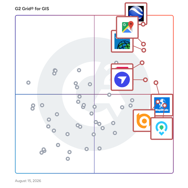
G2 Grid® for GIS Software

G2 Grid® for GIS Software plotting products by satisfaction and market presence

Highlighted products: Google Earth Pro, Google Maps Platform, Esri ArcGIS, AutoCAD, Maptitude, DroneDeploy, Mapme, and BatchGeo.

Underlying data: [Grid® JSON](https://www.g2.com/categories/gis/grids.json?focus%5B%5D=google-earth-pro&focus%5B%5D=google-maps-platform&focus%5B%5D=esri-arcgis&focus%5B%5D=autocad&focus%5B%5D=maptitude&focus%5B%5D=dronedeploy&focus%5B%5D=mapme&focus%5B%5D=batchgeo)

GeoTrellis

GeoTrellis provides a number of operations to manipulate raster data, including cropping/warping, Map Algebra operations, and rendering operations, as well as vector to raster operations such as Kernel Density and vectorization of raster data.

Who Is the Company Behind GeoTrellis?

  • Seller: Azavea
  • Year Founded: 2000
  • HQ Location: Philadelphia, US
  • Twitter: @HunchLab
    74 Twitter followers
  • LinkedIn® Page: www.linkedin.com
    9 employees on LinkedIn®

GIMLabs

Geotechnical information management platform. Built for the way you actually work. GIMLabs replaces spreadsheets, paper logs and legacy software with one platform built for geotechnical teams. Capture data on-site with Log. Manage and edit in Manage. Analyse in Excel with Calc. Export to AGS, PDF or your own templates. Built by engineers who've been on-site and know the pain of bad data workflows. Now with integrated mapping - historical OS maps, BGS geology layers, your locations in one view and so much more.

Who Is the Company Behind GIMLabs?

  • Seller: GIMLabs
  • Year Founded: 2022
  • HQ Location: Global, GB
  • LinkedIn® Page: www.linkedin.com
    2 employees on LinkedIn®

GISCARTA

GISCARTA is a geospatial intelligence company with over 10 years of experience, offering an advanced GIS platform along with mapping and analytics services. We support decision-making across industries — from urban planning and real estate to oil and gas — by delivering precise, actionable location-based insights.

Who Is the Company Behind GISCARTA?

GISGRO

GISGRO is a smart and easy-to-use online platform for infrastructure management. With GISGRO infrastructure owners, managers or maintenance staff can easily access and log information such as repair work, technical maintenance or operational data in an easy to understand visual format. GISGRO digitalizes physical structures and enables efficient management of infrastructure for anyone, at any time and remotely from any place. Infrastructure management has never been this smooth.   GISGRO has been developed by VRT Finland to make better use of underutilized survey data. VRT Finland is the pioneer and expert in surveying of infrastructure such as harbors, bridges, dams and pipelines. More information: www.gisgro.com

Who Is the Company Behind GISGRO?

GIS in SaaS model

We are enabling municipalities, businesses and institutions to efficiently acquire, store, present, manage, and utilize their geospatial data with our future-proof 2D/3D Geographic Information Systems.

Who Is the Company Behind GIS in SaaS model?

GovPilot

When local government departments run their own siloed systems, no one has the full picture. A permit gets issued without recognizing an open code violation. An inspection gets scheduled without seeing the pending stormwater complaint. GovPilot eliminates these blind spots by putting 125+ municipal functions on a single workflow management platform with a shared view of properties, assets, and workflows across departments. Staff configure the platform to match the way they actually work, and implementation takes weeks, not months.

Who Is the Company Behind GovPilot?

  • Seller: GovPilot
  • Year Founded: 2015
  • HQ Location: Brick, NJ 08723
  • LinkedIn® Page: www.linkedin.com
    41 employees on LinkedIn®

Hivemapper

Hivemapper is modern mapping infrastructure. Hivemapper provides mapping, visualization, and analytic tools—for humans and machines alike—that uncover changes humans can’t see. Our machine vision powered mapping tools help forward thinking businesses and organizations build and visualize smarter living maps.

Average Rating: 3.8/5.0

Total Reviews: 3

How Do G2 Users Rate Hivemapper?

  • Ease of Use: 8.9/10 (Category avg: 8.4/10)

Who Is the Company Behind Hivemapper?

  • Seller: Hivemapper
  • Year Founded: 2015
  • HQ Location: San Francisco, US
  • Twitter: @Hivemapper
    56,511 Twitter followers
  • LinkedIn® Page: www.linkedin.com
    52 employees on LinkedIn®

Who Uses This Product?

  • Company Size: 67% Medium, 33% Large

What Are Recent G2 Reviews of Hivemapper?

HOGS Maps

Who Is the Company Behind HOGS Maps?

  • Seller: Hogs
  • Year Founded: 2018
  • HQ Location: Gdańsk, PL
  • LinkedIn® Page: www.linkedin.com
    32 employees on LinkedIn®

HooMap

HooMap is a browser-based, high-performance geospatial data visualization tool designed to replace complex, resource-heavy GIS software. It enables researchers, data analysts, and professionals to instantly transform CSV/Excel coordinate data into interactive, professional-grade maps.

Who Is the Company Behind HooMap?

iGIS

Indictrans is one of the pioneers in GIS segment for India. So, you benefit from our extensive experience, proven track record and in-depth understanding of trends in spatial data and analysis.

Who Is the Company Behind iGIS?

IGIS Map Tool

IGIS Map Tool helps in creating fully featured and interactive web maps in minutes, which provides visualization of almost every format of core datasets to help you understand the demographics, develop solutions for critical problems and analytic reports according to your needs.

Who Is the Company Behind IGIS Map Tool?

IIC GIS

IIC Technologies is a CMMI level 3 rated, ISO 27001, ISO 20000-1 and ISO 9001 accredited global provider of geospatial solutions and services. We provide consultancy, training and specialist services to our clients in government (national, state, and local), defense, Aeronautics, maritime, water resources, utilities, and transportation sectors.

Who Is the Company Behind IIC GIS?

Inframappa

InfraMappa is a cloud-based facility-management and digital-twin platform that turns scattered plans, spreadsheets, and institutional memory into a live, searchable map of every asset, indoors and out. Clients are live in weeks and billed at an annual subscription rate—no GIS specialists, costly consultants, or special training required. Facility managers, maintenance leaders, capital-planning teams, and public-works directors use InfraMappa to locate shut-offs in seconds, create accurate budgets, quickly share information with construction teams, prevent unplanned downtime, and run their operations more efficiently. InfraMappa handles all onboarding at no cost. We collect your paper drawings and digital files, fill data gaps with new imagery, digitize everything, and verify it in the field. The result is an intuitive, cloud-based infrastructure digital twin accessible by any authorized user 24/7 across devices. Key capabilities • Full-service data onboarding InfraMappa manages scanning, correction, and digitization of legacy maps and records, delivering a validated data set that’s ready to use and constantly updated. • Comprehensive digital twin Get a holistic model of above- and below-ground assets, eliminating reliance on outdated paper maps and disconnected scans. • Multi-mode visualization Access 2D web maps, 3D augmented-reality overlays, and VR walk-throughs so teams can interact with assets in the office, in the field, or remotely. • All-inclusive subscription pricing A single annual subscription—priced by acreage, system count, and interior/exterior scope—covers an organization’s entire staff, contractors, and partners, with no per-user fees or hidden charges. • Lifecycle planning & predictive maintenance Track asset age and condition, attach inspection history, and generate reports on replacement and maintenance costs based on local market data to support data-driven budgeting. • System integrations InfraMappa consolidates tabular and IoT sensor data into the map view and connects with asset-management systems and other related software (such as IBM Maximo, Siemens Brightly, ESRI ArcGIS, and others) for a single source of truth. InfraMappa’s SaaS platform offers continuous software updates, full data backups, and live support. And InfraMappa maintains your digital twin—clients simply send new documentation, and our team manages the updates to provide an always-accurate representation of your facility. By replacing paper binders, siloed spreadsheets, and one-off GIS projects, InfraMappa gives facilities teams a clear, current picture of their infrastructure, shortens emergency response, and enables proactive capital planning—all through a single, easy-to-use platform.

Who Is the Company Behind Inframappa?
Daniel Rivera
DR
Researched and written by Daniel Rivera
Updated March 4, 2025