Top Free GIS Software - Page 5

How Many GIS Software Products Does G2 Track?

Total Products under this Category: 415

Category Stats (Sep 2026)

  • Average Rating: 4.29/5 The average rating of products in this category, based on all submitted ratings
  • Top Trending Product: Smappen (+9.51%) - Among all products in this category, Smappen recorded the largest rating increase compared to last month

Last updated: September 01, 2026

How Does G2 Rank GIS Software Products?

Why You Can Trust G2's Software Rankings:

  • 30 Analysts and Data Experts
  • 8,100+ Authentic Reviews
  • 415+ Products
  • Unbiased Rankings

G2's software rankings are built on verified user reviews, rigorous moderation, and a consistent research methodology maintained by a team of analysts and data experts. Each product is measured using the same transparent criteria, with no paid placement or vendor influence. While reviews reflect real user experiences, which can be subjective, they offer valuable insight into how software performs in the hands of professionals. Together, these inputs power the G2 Score, a standardized way to compare tools within every category.

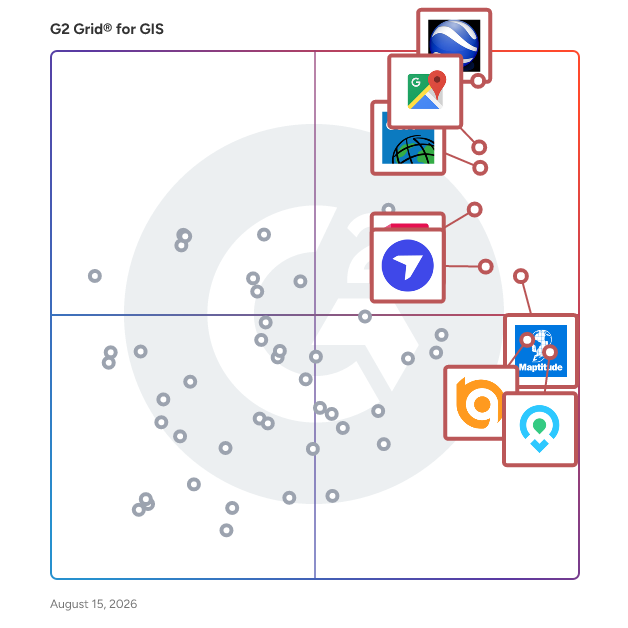
G2 Grid® for GIS Software

G2 Grid® for GIS Software plotting products by satisfaction and market presence

Highlighted products: Google Earth Pro, Google Maps Platform, Esri ArcGIS, AutoCAD, Maptitude, DroneDeploy, Mapme, and BatchGeo.

Underlying data: [Grid® JSON](https://www.g2.com/categories/gis/grids.json?focus%5B%5D=google-earth-pro&focus%5B%5D=google-maps-platform&focus%5B%5D=esri-arcgis&focus%5B%5D=autocad&focus%5B%5D=maptitude&focus%5B%5D=dronedeploy&focus%5B%5D=mapme&focus%5B%5D=batchgeo)

TargomoLOOP

TargomoLOOP is a location optimization tool that assists brick-and-mortar businesses such as shops, restaurants, and service providers in strategic location planning and decision-making. TargomoLOOP is a centralized platform for managing all of your business's location-based information, including customer demographics, retail sales, and service area offerings. Insights gained from this method can be used to examine and enhance retail and hospitality locations, as well as to plot development and optimize the network. Analytics powered by AI can accurately predict sales with an accuracy of 80-90%, as well as find the success drivers of firms and growth possibilities.

Average Rating: 4.0/5.0

Total Reviews: 1

How Do G2 Users Rate TargomoLOOP?

  • Ease of Use: 8.3/10 (Category avg: 8.4/10)

Who Is the Company Behind TargomoLOOP?

  • Seller: Targomo
  • Year Founded: 2013
  • HQ Location: Berlin, DE
  • Twitter: @targomo
    1,212 Twitter followers
  • LinkedIn® Page: www.linkedin.com
    22 employees on LinkedIn®

Who Uses This Product?

  • Company Size: 100% Small

What Do G2 Reviewers Say About TargomoLOOP?

AI-generated summary from verified user reviews

Pros
  • Users value the effective heat map generation of TargomoLOOP for identifying optimal store locations.
  • Users find TargomoLOOP's map creation capabilities invaluable for identifying strategic locations for new store openings.
  • Users value TargomoLOOP for its powerful tools that effectively create heat maps for strategic store placements.

What Are Recent G2 Reviews of TargomoLOOP?

Viewer for mobile mapping & aerial data GEORIZON

The GEORIZON Viewer is a high-performance, web-based geospatial viewer designed for visualizing and exploring large datasets from mobile mapping systems, aerial surveys, drone imagery, and LiDAR sensors. The platform provides a vendor-independent environment where organizations can combine multiple geospatial data sources and interact with them directly in the browser. GEORIZON supports a wide range of data types commonly used in modern geospatial workflows, including panoramic street-level imagery, aerial imagery (nadir and oblique), drone imagery, LiDAR point clouds, textured 3D meshes, elevation models, and vector layers. These datasets can be viewed simultaneously within a single interface, allowing users to move seamlessly between ground-level imagery, aerial perspectives, and 3D spatial data. This integrated visualization makes it possible to analyze spatial environments with both photographic detail and accurate 3D geometry. A key characteristic of the GEORIZON Viewer is its vendor-independent architecture. The platform is designed to work with data from different mobile mapping systems, aerial survey providers, drone mapping platforms, and LiDAR sensors. This allows organizations to combine datasets from multiple vendors within a single viewer and prevents dependency on proprietary ecosystems. As a result, organizations retain full control over their geospatial data infrastructure. The viewer is optimized for large geospatial datasets, enabling efficient streaming of high-resolution imagery and dense LiDAR point clouds directly in the web browser. Users can navigate large areas smoothly without requiring specialized desktop GIS software. Built-in tools support measurements, spatial inspection, and interactive exploration of imagery and 3D data. GEORIZON integrates seamlessly with existing GIS platforms, CAD systems, and asset management software through APIs and standard geospatial services. This allows imagery, LiDAR, and 3D datasets to be connected to existing geospatial workflows and enterprise systems. The viewer can also be embedded in web applications or digital platforms to provide access to geospatial data across organizations. The platform plays an important role in digital twin environments, where large geospatial datasets represent real-world locations. By combining mobile mapping imagery, aerial imagery, drone data, LiDAR point clouds, and 3D models in a single viewer, GEORIZON provides a scalable visualization layer for organizations working with complex geospatial and digital twin datasets.

Who Is the Company Behind Viewer for mobile mapping & aerial data GEORIZON?