# Best Urban Planning and Design Software - Page 2

## How Many Urban Planning and Design Software Products Does G2 Track?

**Total Products under this Category:** 35

### Category Stats (Aug 2026)

- **Average Rating:** 4.43/5 (↑0.02 vs Jul 2026) The average rating of products in this category, based on all submitted ratings
- **Top Trending Product:** Archicad (+0.07%) - Among all products in this category, Archicad recorded the largest rating increase compared to last month

_Last updated: August 01, 2026_

## How Does G2 Rank Urban Planning and Design Software Products?

**Why You Can Trust G2's Software Rankings:**

- 30 Analysts and Data Experts
- 2,900+ Authentic Reviews
- 35+ Products
- Unbiased Rankings

G2's software rankings are built on verified user reviews, rigorous moderation, and a consistent research methodology maintained by a team of analysts and data experts. Each product is measured using the same transparent criteria, with no paid placement or vendor influence. While reviews reflect real user experiences, which can be subjective, they offer valuable insight into how software performs in the hands of professionals. Together, these inputs power the G2 Score, a standardized way to compare tools within every category.

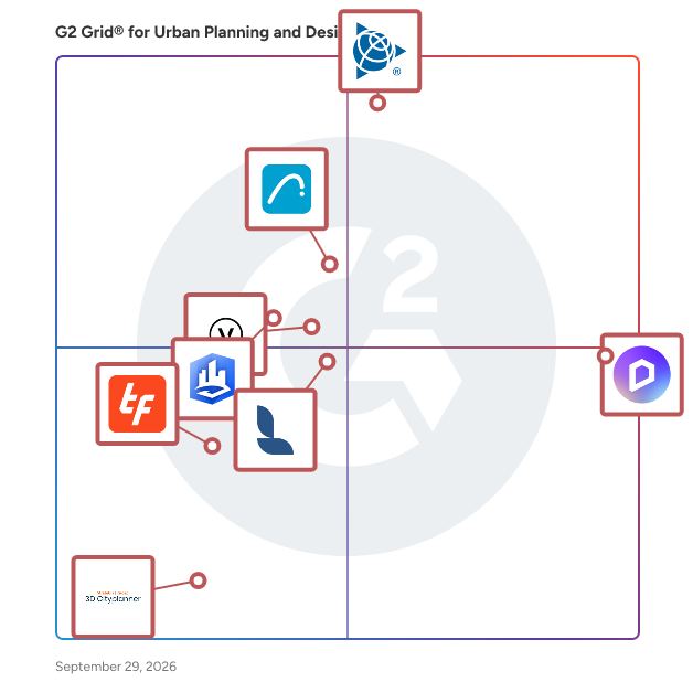
## G2 Grid® for Urban Planning and Design Software
 ![G2 Grid® for Urban Planning and Design Software plotting products by satisfaction and market presence](https://www.g2.com/categories/urban-planning-and-design/grids.png?focus%5B%5D=1798&focus%5B%5D=149352&focus%5B%5D=2989&focus%5B%5D=18817&focus%5B%5D=5318&focus%5B%5D=18336&focus%5B%5D=142586&focus%5B%5D=165970)

Highlighted products: SketchUp, D5 Render, Archicad, Lumion Pro, Vectorworks Landmark, ArcGIS CityEngine, TestFit, and 3D Cityplanner.

Underlying data: [Grid® JSON](https://www.g2.com/categories/urban-planning-and-design/grids.json?focus%5B%5D=sketchup&focus%5B%5D=d5-render&focus%5B%5D=archicad&focus%5B%5D=lumion-pro&focus%5B%5D=vectorworks-landmark&focus%5B%5D=arcgis-cityengine&focus%5B%5D=testfit&focus%5B%5D=3d-cityplanner)

**Sponsored**

### cmBuilder.io

cmBuilder democratizes 4D construction site logistics with fast & easy cloud-based workflows, powerful sequencing simulation capabilities, and unparalleled real-time collaboration.

[Visit website](https://www.g2.com/external_clickthroughs/record?secure%5Bad_program%5D=ppc&secure%5Bad_slot%5D=category_product_list_llm&secure%5Bcategory_id%5D=2032&secure%5Bchosen_at%5D=2026-08-02T07%3A53%3A19Z&secure%5Bdisplayable_resource_id%5D=292&secure%5Bdisplayable_resource_type%5D=Category&secure%5Bmedium%5D=sponsored&secure%5Bplacement_reason%5D=neighbor_category&secure%5Bplacement_resource_ids%5D%5B%5D=292&secure%5Bprioritized%5D=false&secure%5Bproduct_id%5D=1324845&secure%5Bresource_id%5D=2032&secure%5Bresource_type%5D=Category&secure%5Bsource_type%5D=category_page&secure%5Bsource_url%5D=https%3A%2F%2Fwww.g2.com%2Fcategories%2Furban-planning-and-design%3Fpage%3D2&secure%5Btoken%5D=729420887e0f7df5b891f499fff82f35ea3b29e7ace8ed944279c7f58c13156c&secure%5Burl%5D=https%3A%2F%2Fwww.cmbuilder.io%2Fconstruction-site-simulation%3Futm_campaign%3DG2_ppc%26utm_source%3Dg2%26utm_medium%3Dreview-site&secure%5Burl_type%5D=custom_url)

### [Bentley OpenCities Planner](https://www.g2.com/products/bentley-opencities-planner/reviews)

OpenCities Planner is a cloud-based service that enables visualization of 2D, 3D, and GIS data in a 3D world. You can design, visualize, and communicate projects from large-scale city developments to detailed architectural designs. Powered by Microsoft Azure, OpenCities Planner is scaled to support users globally and offers robust performance and multilayered security thanks to the extensive network of Microsoft's datacenters. All you need is a web browser as OpenCities Planner is completely web based and plug-in free. OpenCities Planner capabilities combined with Bentley’s reality modeling offerings make city-scale digital twins broadly accessible. Synchronizing reality and ‘virtuality,’ OpenCities Planner offers the perfect web solution to enable every city government in going digital. Scalable for all organization types from individual planners, architects, GIS engineers to city governments, and larger organizations.

**Average Rating:** 5.0/5.0

**Total Reviews:** 1

#### How Do G2 Users Rate Bentley OpenCities Planner?

- **Quality of Support:** 8.3/10 (Category avg: 8.4/10)
- **Sequence:** 8.3/10 (Category avg: 7.8/10)
- **3D Modeling:** 10.0/10 (Category avg: 8.5/10)

#### Who Is the Company Behind Bentley OpenCities Planner?

- **Seller:** [Bentley Systems](https://www.g2.com/sellers/bentley-systems)
- **Year Founded:** 1984
- **HQ Location:** Exton, PA
- **Twitter:** @BentleySystems  
17,564 Twitter followers
- **LinkedIn® Page:** [www.linkedin.com](https://www.g2.com/external_clickthroughs/record?secure%5Bsource_type%5D=product_profile&secure%5Btoken%5D=3dcf7c9e5c41323034d72c8b4aaa7d0fc90f77668995d474f35466baaee4ef4b&secure%5Burl%5D=https%3A%2F%2Fwww.linkedin.com%2Fcompany%2F4929%2F&secure%5Burl_type%5D=linkedin_company_website)  
5,621 employees on LinkedIn®
- **Ownership:** NASDAQ: BSY

#### Who Uses This Product?

- **Company Size:** 100% Medium

#### What Are Recent G2 Reviews of Bentley OpenCities Planner?

**["Easiest planning tool"](https://www.g2.com/survey_responses/bentley-opencities-planner-review-6822064)**

**Rating:** 5.0/5.0 stars

_— Dr. Tanmay G._

[Read full review](https://www.g2.com/survey_responses/bentley-opencities-planner-review-6822064)

### [Giraffe](https://www.g2.com/fr/products/giraffe/reviews)

Giraffe est la plateforme pour l'analyse urbaine. Connectez les personnes, les projets et les données. Rapide et Précis : Dessinez une volumétrie en position en quelques secondes. Intelligent et connecté : Gérez facilement vos hypothèses et définissez des métriques personnalisées. Analyse Instantanée : Pendant que vous esquissez, Giraffe vous montre des rendements à jour pour évaluer votre conception. Collaborez sans effort : Travaillez ensemble en temps réel. Voyez instantanément les mises à jour de votre équipe. Flux de travail suralimentés : Les outils de dessin génératifs automatisent les tâches fastidieuses.

**Average Rating:** 4.5/5.0

**Total Reviews:** 1

#### Who Is the Company Behind Giraffe?

- **Vendeur:** [Giraffe](https://www.g2.com/fr/sellers/giraffe)
- **Année de fondation:** 2017
- **Emplacement du siège social:** Sydney, AU
- **Page LinkedIn®:** [www.linkedin.com](https://www.g2.com/fr/external_clickthroughs/record?secure%5Bsource_type%5D=product_profile&secure%5Btoken%5D=0b8c00e04b65fec19880921ed48cc052d6f1de5641ac57ede6529a160ffb7427&secure%5Burl%5D=https%3A%2F%2Fwww.linkedin.com%2Fcompany%2Fgiraffebuild%2F&secure%5Burl_type%5D=linkedin_company_website)  
17 employés sur LinkedIn®

#### Who Uses This Product?

- **Company Size:** 100% Small

#### What Do G2 Reviewers Say About Giraffe?

_AI-generated summary from verified user reviews_

##### Pros

- Les utilisateurs apprécient la **facilité d'utilisation** de Giraffe, louant le flux de travail simple et les résultats positifs.
- Les utilisateurs apprécient le **flux de travail facile et la visualisation** de Giraffe, améliorant leur expérience et leur satisfaction avec les résultats.
- Les utilisateurs adorent le **flux de travail facile et les résultats positifs** obtenus avec Giraffe, améliorant ainsi leur efficacité globale.

#### What Are Recent G2 Reviews of Giraffe?

**["Répondu aux attentes élevées en matière de flux de travail et de qualité"](https://www.g2.com/fr/survey_responses/giraffe-review-7442546)**

**Rating:** 4.5/5.0 stars

_— Drishti C._

[Read full review](https://www.g2.com/fr/survey_responses/giraffe-review-7442546)

### [Modelur](https://www.g2.com/products/modelur/reviews)

Modelur is an easy-to-use, yet very powerful parametric urban design software tool, developed to help you quickly create conceptual urban massing. It calculates key urban control parameters on the fly (e.g. FAR or required number of parking lots), delivering important information while design is still evolving. This way it fosters well-informed decision making during the earliest stages, when design decisions have the highest impact.

**Average Rating:** 4.0/5.0

**Total Reviews:** 1

#### Who Is the Company Behind Modelur?

- **Seller:** [Modelur](https://www.g2.com/sellers/modelur)
- **Year Founded:** 2017
- **HQ Location:** Ljubljana, SI
- **Twitter:** @Modelur  
547 Twitter followers
- **LinkedIn® Page:** [www.linkedin.com](https://www.g2.com/external_clickthroughs/record?secure%5Bsource_type%5D=product_profile&secure%5Btoken%5D=18d4549e21fa4c18237d9bf83626db0a7f466a335a1b481275f08e3bad890d29&secure%5Burl%5D=https%3A%2F%2Fwww.linkedin.com%2Fcompany%2Fagilicity%2F&secure%5Burl_type%5D=linkedin_company_website)  
4 employees on LinkedIn®

#### Who Uses This Product?

- **Company Size:** 100% Large

#### What Are Recent G2 Reviews of Modelur?

**["Best 3D modelling software out there!"](https://www.g2.com/survey_responses/modelur-review-5314532)**

**Rating:** 4.0/5.0 stars

_— KALPIT P._

[Read full review](https://www.g2.com/survey_responses/modelur-review-5314532)

### [PTV Visum](https://www.g2.com/fr/products/ptv-visum/reviews)

PTV Visum est le logiciel leader pour la planification des transports macroscopiques et mésoscopiques et la modélisation de la mobilité. Il permet aux villes, agences, consultants et chercheurs de simuler des systèmes de transport multimodaux incluant les véhicules privés, les transports en commun, les piétons et les modes actifs. La plateforme prend en charge la modélisation de la demande, l'affectation du trafic, la planification des transports publics, l'analyse basée sur les SIG et la prévision des émissions. Son architecture flexible et ses API ouvertes permettent une intégration transparente avec des données et outils externes. Cas d'utilisation clés : 1. Planification stratégique des transports 2. Optimisation du réseau de transport public et des horaires 3. Prévision et affectation de la demande de trafic 4. Évaluation des politiques et des scénarios (par exemple, ZFE, péage, MaaS) 5. Analyse de l'impact des infrastructures 6. Évaluation de l'accessibilité et des émissions 7. Planification des investissements pluriannuels 8. Soutien aux Plans de Mobilité Urbaine Durable (PMUD) PTV Visum fournit des informations basées sur les données pour façonner des stratégies de mobilité à long terme aux niveaux municipal, régional et national.

**Average Rating:** 4.8/5.0

**Total Reviews:** 3

#### How Do G2 Users Rate PTV Visum?

- **Qualité du support:** 10.0/10 (Category avg: 8.4/10)

#### Who Is the Company Behind PTV Visum?

- **Vendeur:** [PTV Group](https://www.g2.com/fr/sellers/ptv-group)
- **Année de fondation:** 1979
- **Emplacement du siège social:** Karlsruhe, Baden-Württemberg, Germany
- **Page LinkedIn®:** [www.linkedin.com](https://www.g2.com/fr/external_clickthroughs/record?secure%5Bsource_type%5D=product_profile&secure%5Btoken%5D=3f3a734b885051fb2fbf349c17165b8eb0cdac8005b00be3f221029d6ca37b7e&secure%5Burl%5D=https%3A%2F%2Fwww.linkedin.com%2Fcompany%2Fptvlogistics%2F&secure%5Burl_type%5D=linkedin_company_website)  
291 employés sur LinkedIn®
- **Téléphone:** +49 721 9651-0

#### Who Uses This Product?

- **Company Size:** 67% Large, 33% Medium

#### What Are Recent G2 Reviews of PTV Visum?

**["Visum est fiable et suffisant pour la plupart des projets de transport."](https://www.g2.com/fr/survey_responses/ptv-visum-review-7793698)**

**Rating:** 4.5/5.0 stars

_— Mark M._

[Read full review](https://www.g2.com/fr/survey_responses/ptv-visum-review-7793698)

**["meilleur logiciel pour la modélisation de la demande de voyage avec un minimum de codage"](https://www.g2.com/fr/survey_responses/ptv-visum-review-8510655)**

**Rating:** 5.0/5.0 stars

_— Sai S._

[Read full review](https://www.g2.com/fr/survey_responses/ptv-visum-review-8510655)

#### What Are G2 Users Discussing About PTV Visum?

- [À quoi sert PTV Visum ?](https://www.g2.com/fr/discussions/what-is-ptv-visum-used-for)

### [ChatAEC](https://www.g2.com/products/chataec/reviews)

ChatAEC AI for development codes, due diligence, and early planning ChatAEC is an AI powered assistant that helps architects, planners, civil engineers, and developers understand site specific rules and requirements in seconds. It analyzes zoning, development codes, overlays, and other local regulations and returns clear, source linked answers that support faster and more accurate project decisions. ChatAEC is built for early stage planning and due diligence. It helps users move from scattered research to one organized workspace where every question, code reference, and project detail lives in a single project chat. What ChatAEC does: Answers development code, zoning, and due diligence questions instantly Identifies allowed uses, setbacks, height limits, density, overlays, and development standards Summarizes long code documents into clear, actionable guidance Creates parcel and project based chats for organized research Produces reports such as Summary of Information and Requirements (SIR) Supports early feasibility, concept planning, and entitlement preparation Links every answer to verified municipal sources for transparency Who it is for: Architects, planners, civil engineers, developers, and real estate teams that need fast clarity on what can be built and what rules apply to a site. Why teams choose ChatAEC Speeds up due diligence and early planning Provides accurate and consistent code interpretation Gives verified source links with every answer Reduces hours of manual research across planning, zoning, and development codes Keeps project research organized in one place ChatAEC helps teams move faster, reduce uncertainty, and make better decisions at the start of any development project.

#### Who Is the Company Behind ChatAEC?

- **Seller:** [Datum Point](https://www.g2.com/sellers/datum-point)
- **HQ Location:** Phoenix, US
- **LinkedIn® Page:** [www.linkedin.com](https://www.g2.com/external_clickthroughs/record?secure%5Bsource_type%5D=product_profile&secure%5Btoken%5D=c15c3882ec5ede81393b8d2e5578f51c06180fa1cc367e553039df84db55deef&secure%5Burl%5D=https%3A%2F%2Fwww.linkedin.com%2Fcompany%2Faiaec-international%2F&secure%5Burl_type%5D=linkedin_company_website)  
17 employees on LinkedIn®

### [CivitPLAN](https://www.g2.com/products/civitplan/reviews)

CivitPLAN by SoftTech Engineers Limited is an advanced AI-powered solution designed to streamline urban planning, zoning approvals, and regulatory compliance. This cloud-based platform empowers government authorities, municipalities, and planning agencies with automated workflows, real-time collaboration, and intelligent rule-based verification to accelerate the planning approval process. Key Benefits: 1-Faster and more efficient planning approvals with automated workflows 2- AI-driven compliance checks for error-free submissions 3- Seamless integration with GIS, BIM, and regulatory databases 4- Real-time tracking and collaboration for all stakeholders 5-Enhanced transparency and efficiency in urban planning CivitPLAN ensures a seamless, digital-first approach to urban development, helping cities grow smarter and more efficiently. For More Information Visit us: https://softtechglobal.com/civit-plan/

#### Who Is the Company Behind CivitPLAN?

- **Seller:** [SoftTech Engineers Limited](https://www.g2.com/sellers/softtech-engineers-limited-e199c26c-a6a7-4826-bebf-ffbedd7451a5)
- **Year Founded:** 1996
- **HQ Location:** Pune, IN
- **LinkedIn® Page:** [www.linkedin.com](https://www.g2.com/external_clickthroughs/record?secure%5Bsource_type%5D=product_profile&secure%5Btoken%5D=4c7b7dc1d3b0e18c7e0869052a5aaef93e8bac1bdc5a050a6097b41e3bcc7c24&secure%5Burl%5D=https%3A%2F%2Fwww.linkedin.com%2Fcompany%2Fsofttech_engineers_pvt._ltd.&secure%5Burl_type%5D=linkedin_company_website)  
604 employees on LinkedIn®

### [EDS Technologies](https://www.g2.com/products/eds-technologies/reviews)

EDS Technologies Pvt. Ltd. , established in 1995, is India's leading provider of engineering solutions, specializing in CAD/CAM/CAE/PLM and real-time visual simulation. With over two decades of experience, EDST empowers industries such as aerospace, automotive, industrial machinery, high-tech electronics, railways, infrastructure, consumer packaged goods, defense, research, and education to achieve their business objectives. Headquartered in Bengaluru, EDST operates across multiple Indian cities, including Chennai, Coimbatore, Gurugram, Hyderabad, Pune, Mumbai, Kolkata, Noida, Ahmedabad, and Chandigarh. Key Features and Functionality: - Comprehensive Solutions Portfolio: EDST offers a wide range of solutions, including engineering simulation, digital manufacturing, and lifecycle management, enabling the creation of virtual twins to drive product innovation and optimize business processes. - Consulting Services: The company provides consulting services focused on optimizing business processes, improving operational efficiency, and facilitating digital transformation. - Industry-Specific Expertise: EDST caters to various industries, including aerospace, automotive, industrial machinery, high-tech electronics, railways, infrastructure, consumer packaged goods, defense, research, and education. Primary Value and Solutions Provided: EDST's primary value lies in its ability to deliver end-to-end engineering solutions that enhance product design, streamline manufacturing processes, and facilitate digital transformation. By leveraging advanced technologies and industry expertise, EDST helps organizations improve productivity, reduce costs, and accelerate time-to-market, thereby driving innovation and achieving business success.

#### Who Is the Company Behind EDS Technologies?

- **Seller:** [EDS Technologies](https://www.g2.com/sellers/eds-technologies)
- **Year Founded:** 1995
- **HQ Location:** Bangalore, IN
- **LinkedIn® Page:** [www.linkedin.com](https://www.g2.com/external_clickthroughs/record?secure%5Bsource_type%5D=product_profile&secure%5Btoken%5D=326a30b5bd1603b5da1ad70b3ecceddecd26e1b6358a216e87e66810b0d31b64&secure%5Burl%5D=https%3A%2F%2Fwww.linkedin.com%2Fcompany%2Feds-technologies%2F&secure%5Burl_type%5D=linkedin_company_website)  
592 employees on LinkedIn®

### [Planary](https://www.g2.com/products/planary/reviews)

Planary is designed for architects and urban planners to simplify complex urban planning tasks by automating calculations and enhancing visualization. Key Features: Automated Feasibility Studies: Quickly assess site potential with real-time data-driven insights. Seamless Revit & AutoCAD Integration: Works within Revit and AutoCAD, fitting seamlessly into existing workflows. Data-Driven Design: Generate reports and visualizations to support informed design decisions. Planary empowers architects and city planners by transforming complex urban analysis into an intuitive, efficient, and technology-driven process.

#### Who Is the Company Behind Planary?

- **Seller:** [AgileForm](https://www.g2.com/sellers/agileform)
- **Year Founded:** 2021
- **HQ Location:** Toronto, CA
- **LinkedIn® Page:** [www.linkedin.com](https://www.g2.com/external_clickthroughs/record?secure%5Bsource_type%5D=product_profile&secure%5Btoken%5D=c4e30c42aabea7b76f4dfff67cb13038624bea7714f297b05838cdf9e120efa8&secure%5Burl%5D=https%3A%2F%2Fwww.linkedin.com%2Fcompany%2Fagileform&secure%5Burl_type%5D=linkedin_company_website)  
4 employees on LinkedIn®

### [PointCab Origins](https://www.g2.com/fr/products/pointcab-origins/reviews)

PointCab – Solutions rapides et intuitives pour le traitement et la collaboration des nuages de points PointCab développe des logiciels intelligents et conviviaux qui transforment les données complexes de nuages de points 3D en résultats exploitables—rapidement et efficacement. Nos solutions sont approuvées par des professionnels de l'architecture, de l'ingénierie, de la construction, de la topographie et de la planification urbaine dans le monde entier. Nous proposons deux produits principaux : PointCab Origins PointCab Origins est une solution de bureau haute performance pour le traitement des données de nuages de points provenant de tout scanner laser. Elle permet aux utilisateurs d'extraire des plans d'étage, des sections, des élévations et des orthoimages en quelques clics seulement—aucune compétence avancée en CAO ou BIM n'est requise. - Fonctionne avec les données de toutes les grandes marques de scanners (par exemple, Faro, Leica, NavVis, Riegl) - Prend en charge l'exportation rapide vers des outils CAO et BIM comme AutoCAD, Revit, Archicad, et plus - Idéal pour les flux de travail scan-to-CAD et scan-to-BIM en architecture, construction et topographie - Économise du temps en simplifiant la documentation as-built et l'analyse spatiale PointCab Nebula PointCab Nebula est notre plateforme basée sur le cloud pour visualiser et partager des données de nuages de points en ligne. Elle permet aux équipes et aux parties prenantes de collaborer sur des données 3D—aucune installation de logiciel n'est nécessaire. - Diffusez des nuages de points via le navigateur - Ajoutez des commentaires, liez des documents et organisez des projets visuellement - Contrôlez l'accès avec des permissions utilisateur - Hébergement de votre choix : Connectez Nebula à votre cloud existant, par exemple Google, AWS ou plus Que vous planifiiez des espaces urbains, documentiez des bâtiments existants ou coordonniez des projets de construction, PointCab rend les flux de travail des nuages de points plus rapides, plus faciles et plus accessibles. Nous comblons le fossé entre la capture de la réalité et les résultats concrets.

#### Who Is the Company Behind PointCab Origins?

- **Vendeur:** [PointCab](https://www.g2.com/fr/sellers/pointcab)
- **Année de fondation:** 2013
- **Emplacement du siège social:** Wernau, DE
- **Page LinkedIn®:** [www.linkedin.com](https://www.g2.com/fr/external_clickthroughs/record?secure%5Bsource_type%5D=product_profile&secure%5Btoken%5D=98370714a449a381ea29c338d59c05b31f8ab9798ee7aaca4fb12fb3fe859423&secure%5Burl%5D=https%3A%2F%2Fwww.linkedin.com%2Fcompany%2Fpointcab-gmbh&secure%5Burl_type%5D=linkedin_company_website)  
12 employés sur LinkedIn®

### [Ratio.City](https://www.g2.com/products/ratio-city/reviews)

Smarter Planning, Faster Decisions Ratio.City is a powerful, map-based platform that accelerates real estate and urban planning decisions. Designed for developers, planners, and municipalities, our intuitive tools simplify complex site analysis, zoning research, and feasibility studies—saving weeks of manual work. With curated, high-quality data layers and dynamic visualizations, Ratio.City helps you identify development opportunities, understand policy constraints, and collaborate more efficiently. Whether you're planning a multi-family residential project or evaluating new housing policy impacts, Ratio.City turns data into actionable insights. From concept to application, Ratio.City de-risks your decisions and empowers faster, more confident planning. Key Features: - Locate Tool – Quickly identify sites with development potential across major cities - Feasibility Analysis – Run high-level development scenarios including zoning and built form constraints - Interactive Mapping – Visualize planning layers, land use policies, and infrastructure data - 3D Massing Generator – Instantly create and compare building massing studies - Reports – Generate ready-to-share summaries for internal or municipal use - Collaboration Tools – Share interactive maps and findings with teams or external partners - Custom Layers & Uploads – Add your own data to layer over city-wide datasets 🌐 Available in Multiple Markets – Currently supporting major Canadian cities, with expansion ongoing...

**Average Rating:** 4.0/5.0

**Total Reviews:** 1

#### How Do G2 Users Rate Ratio.City?

- **Quality of Support:** 10.0/10 (Category avg: 8.4/10)

#### Who Is the Company Behind Ratio.City?

- **Seller:** [Esri Canada](https://www.g2.com/sellers/esri-canada)
- **Year Founded:** 2017
- **HQ Location:** Toronto, CA
- **LinkedIn® Page:** [www.linkedin.com](https://www.g2.com/external_clickthroughs/record?secure%5Bsource_type%5D=product_profile&secure%5Btoken%5D=c0689d53863add5a22fa8a60f8dc99a994901c2e8921a52b361e9c8ffb3b9cc4&secure%5Burl%5D=https%3A%2F%2Fwww.linkedin.com%2Fcompany%2Fratio-city&secure%5Burl_type%5D=linkedin_company_website)  
15 employees on LinkedIn®

#### Who Uses This Product?

- **Company Size:** 100% Medium

#### What Do G2 Reviewers Say About Ratio.City?

_AI-generated summary from verified user reviews_

##### Pros

- Users praise the **user-friendly interface** of Ratio.City, appreciating its simplicity and efficiency for seamless navigation.

#### What Are Recent G2 Reviews of Ratio.City?

**["Very good experience"](https://www.g2.com/survey_responses/ratio-city-review-10693975)**

**Rating:** 4.0/5.0 stars

_— Christine H._

[Read full review](https://www.g2.com/survey_responses/ratio-city-review-10693975)

### [Simplex 3D](https://www.g2.com/products/simplex-3d/reviews)

Simplex 3D is a groundbreaking 3D visualization platform that empowers real estate professionals to plan, analyze, and present projects with unmatched accuracy and context. Using patented aerial photography technology, the platform transforms massive data into a highly accurate, real-life 3D model—seamlessly integrated with powerful tools and enriched data layers. With a unified workspace for visualizing, analyzing, and optimizing urban projects, Simplex 3D reveals hidden opportunities, reduces risk, and helps teams work smarter.

#### Who Is the Company Behind Simplex 3D?

- **Seller:** [Simplex 3D](https://www.g2.com/sellers/simplex-3d)
- **Year Founded:** 2013
- **HQ Location:** Herzliya, IL
- **LinkedIn® Page:** [www.linkedin.com](https://www.g2.com/external_clickthroughs/record?secure%5Bsource_type%5D=product_profile&secure%5Btoken%5D=4b41a5c1866503d74cba49f7ba0059e7bc280b04faed2aa93347883d519fa035&secure%5Burl%5D=https%3A%2F%2Fwww.linkedin.com%2Fcompany%2Fsimplex3d&secure%5Burl_type%5D=linkedin_company_website)  
56 employees on LinkedIn®

### [SimWalk-360](https://www.g2.com/products/simwalk-360/reviews)

SimWalk is a leading pedestrian simulation software for transport, aviation, urban planning and architecture.

**Average Rating:** 5.0/5.0

**Total Reviews:** 1

#### Who Is the Company Behind SimWalk-360?

- **Seller:** [SimWalk](https://www.g2.com/sellers/simwalk)
- **HQ Location:** N/A
- **Twitter:** @SimWalkSoftware  
223 Twitter followers
- **LinkedIn® Page:** [www.linkedin.com](https://www.g2.com/external_clickthroughs/record?secure%5Bsource_type%5D=product_profile&secure%5Btoken%5D=7886df2ed926834e5eb248c77dcfa8e5c815d3ab1f0fe3132ced0dba45868834&secure%5Burl%5D=https%3A%2F%2Fwww.linkedin.com%2Fcompany%2FNo-Linkedin-Presence-Added-Intentionally-By-DataOps&secure%5Burl_type%5D=linkedin_company_website)  
1 employees on LinkedIn®

#### Who Uses This Product?

- **Company Size:** 100% Small

#### What Are Recent G2 Reviews of SimWalk-360?

**["Trusted software with 2D/3D visualizations available"](https://www.g2.com/survey_responses/simwalk-360-review-8748629)**

**Rating:** 5.0/5.0 stars

_— Anket A._

[Read full review](https://www.g2.com/survey_responses/simwalk-360-review-8748629)

### [SimWalk PRO](https://www.g2.com/products/simwalk-pro/reviews)

SimWalk PRO integrates the CAD software SimDraw for easier adaptation of simulation plans. In addition, SimWalk Event Handler allows creating highly dynamic simulations with integrated run-time events.

#### Who Is the Company Behind SimWalk PRO?

- **Seller:** [SimWalk](https://www.g2.com/sellers/simwalk)
- **HQ Location:** N/A
- **Twitter:** @SimWalkSoftware  
223 Twitter followers
- **LinkedIn® Page:** [www.linkedin.com](https://www.g2.com/external_clickthroughs/record?secure%5Bsource_type%5D=product_profile&secure%5Btoken%5D=7886df2ed926834e5eb248c77dcfa8e5c815d3ab1f0fe3132ced0dba45868834&secure%5Burl%5D=https%3A%2F%2Fwww.linkedin.com%2Fcompany%2FNo-Linkedin-Presence-Added-Intentionally-By-DataOps&secure%5Burl_type%5D=linkedin_company_website)  
1 employees on LinkedIn®

### [Snaptrude](https://www.g2.com/products/snaptrude/reviews)

Snaptrude is a web-based 3D modeling software (BIM) for Architects and Designers. Designers use Snaptrude to create better buildings faster with the help of data and automation. Unlike other design tools, Snaptrude allows for multiplayer collaboration enabling project teams to design together.

#### Who Is the Company Behind Snaptrude?

- **Seller:** [Snaptrude](https://www.g2.com/sellers/snaptrude)
- **Year Founded:** 2017
- **HQ Location:** New York, New York, United States
- **LinkedIn® Page:** [www.linkedin.com](https://www.g2.com/external_clickthroughs/record?secure%5Bsource_type%5D=product_profile&secure%5Btoken%5D=011043aaf7ff1f4d41ab539f81fda0c8181e2e21e0f10e8b1a8b04871de281e0&secure%5Burl%5D=https%3A%2F%2Fwww.linkedin.com%2Fcompany%2Fsnaptrude&secure%5Burl_type%5D=linkedin_company_website)  
79 employees on LinkedIn®

### [UrbanCanvas Modeler](https://www.g2.com/products/urbancanvas-modeler/reviews)

UrbanCanvas Modeler is a web-based platform designed for planners and modelers to generate long-range, small area socioeconomic forecasts using UrbanSim to inform Regional Transportation Plans. You can craft and analyze multiple scenarios using an interactive 2D and 3D mapping environment to manage model data inputs and results. You can quickly configure and launch UrbanSim simulations harnessing cloud-based, scalable, on demand computing power. UrbanCanvas Modeler is designed to help planners manage workflows for developing input data relevant to land use and future development. It also supports rapidly creating new policy and investment scenarios and running UrbanSim simulations to explore their impacts on the real-estate market. UrbanCanvas Modeler makes UrbanSim accessible to users regardless of in-house technical expertise and computing capacity. UrbanCanvas Modeler is provided as an annual or monthly subscription basis, with new features and data updates incorporated as they become available.

#### Who Is the Company Behind UrbanCanvas Modeler?

- **Seller:** [UrbanSim](https://www.g2.com/sellers/urbansim)
- **Year Founded:** 2016
- **HQ Location:** Berkeley, US
- **LinkedIn® Page:** [www.linkedin.com](https://www.g2.com/external_clickthroughs/record?secure%5Bsource_type%5D=product_profile&secure%5Btoken%5D=3fd05ddd4f363f7b2d81d001fd104daf33a4ea508d1392ea55083efdc174bca1&secure%5Burl%5D=https%3A%2F%2Fwww.linkedin.com%2Fcompany%2Furbansim&secure%5Burl_type%5D=linkedin_company_website)  
8 employees on LinkedIn®

- [&lsaquo; Prev‹ Prev](/categories/urban-planning-and-design?order=g2_score#product-list)
- [1](/categories/urban-planning-and-design?order=g2_score#product-list)
- 2
- [3](/categories/urban-planning-and-design?order=g2_score&page=3#product-list)
- [Next &rsaquo;Next ›](/categories/urban-planning-and-design?order=g2_score&page=3#product-list)

Spotlight Categories

[Integration Platform as a Service (iPaaS) Solutions](https://www.g2.com/categories/ipaas)

[Customer Success Software](https://www.g2.com/categories/customer-success)

[Project Management Software](https://www.g2.com/categories/project-management)

[Media Monitoring Software](https://www.g2.com/categories/media-monitoring)

[Sales Training and Onboarding Software](https://www.g2.com/categories/sales-training-and-onboarding)

Similar Categories

- [Additive Manufacturing](/categories/additive-manufacturing)
- [BIM Objects](/categories/bim-objects)
- [CAD](/categories/cad)
- [Computer-Aided Manufacturing (CAM)](/categories/computer-aided-manufacturing-cam)

- [Engineering Document Management](/categories/engineering-document-management)
- [GIS](/categories/gis)
- [Photogrammetry](/categories/photogrammetry)
- [Plant Design Management Systems](/categories/plant-design-management-systems)

- [Product Data Management (PDM)](/categories/product-data-management-pdm)
- [Product Lifecycle Management (PLM)](/categories/product-lifecycle-management-plm)
- [Robotic Simulation Software](/categories/robotic-simulation-software)
- [Simulation & CAE](/categories/simulation-cae)

[Browse Urban Planning and Design Themes](/categories/urban-planning-and-design/themes)

 ![Daniel Rivera](/assets/transparent-ad5be28fbcd25b7b08d2cebe1d957125437fb5407d75ee717965ad22c8808791.gif "Daniel Rivera")
DR

Researched and written by [Daniel Rivera](https://research.g2.com/insights/author/daniel-rivera)

Updated October 3, 2024

Urban planning and design software is used to plan urban layouts and design 3D models of urban environments. City planners and architects use urban planning and design software to conceptualize how their urban designs would look in the real world. By creating 3D visualizations, urban designers can enhance their urban planning proposals and design urban layouts that abide by city zoning rules. Urban planning and design software is often used by architects, city planners, or any creative department involved with designing the layout of an urban environment. Users can integrate [GIS software](https://www.g2.com/categories/gis) into their urban planning and design software to automatically import structures that already exist in the real world. This saves users time and allows urban planners to build around the preexisting infrastructure of an urban environment.

To qualify for inclusion in the Urban Planning and Design category, a product must:

- Facilitate designing urban environments in either a 3D or 2D environment
- Import detailed 3D models from CAD, GIS, or web services
- Provide users with the ability to collaborate and share design projects with other team members

Show More