Best GIS Software - Page 8

How Many GIS Software Products Does G2 Track?

Total Products under this Category: 414

Category Stats (Sep 2026)

  • Average Rating: 4.29/5 The average rating of products in this category, based on all submitted ratings
  • Top Trending Product: Smappen (+9.51%) - Among all products in this category, Smappen recorded the largest rating increase compared to last month

Last updated: September 01, 2026

How Does G2 Rank GIS Software Products?

Why You Can Trust G2's Software Rankings:

  • 30 Analysts and Data Experts
  • 8,100+ Authentic Reviews
  • 414+ Products
  • Unbiased Rankings

G2's software rankings are built on verified user reviews, rigorous moderation, and a consistent research methodology maintained by a team of analysts and data experts. Each product is measured using the same transparent criteria, with no paid placement or vendor influence. While reviews reflect real user experiences, which can be subjective, they offer valuable insight into how software performs in the hands of professionals. Together, these inputs power the G2 Score, a standardized way to compare tools within every category.

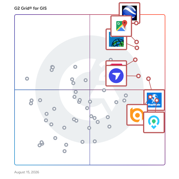
G2 Grid® for GIS Software

G2 Grid® for GIS Software plotting products by satisfaction and market presence

Highlighted products: Google Earth Pro, Google Maps Platform, Esri ArcGIS, AutoCAD, Maptitude, DroneDeploy, Mapme, and BatchGeo.

Underlying data: [Grid® JSON](https://www.g2.com/categories/gis/grids.json?focus%5B%5D=google-earth-pro&focus%5B%5D=google-maps-platform&focus%5B%5D=esri-arcgis&focus%5B%5D=autocad&focus%5B%5D=maptitude&focus%5B%5D=dronedeploy&focus%5B%5D=mapme&focus%5B%5D=batchgeo)

Anysite

AnySite is the essential decision-support solution for analysts and executives looking to uncover the relationship between trade-area demographics and site potential.

Average Rating: 4.5/5.0

Total Reviews: 2

How Do G2 Users Rate Anysite?

  • Data Capture: 10.0/10 (Category avg: 8.6/10)
  • Data Visualization: 9.2/10 (Category avg: 8.6/10)
  • Ease of Use: 9.2/10 (Category avg: 8.4/10)
  • Spatial Analysis: 6.7/10 (Category avg: 8.4/10)

Who Is the Company Behind Anysite?

Who Uses This Product?

  • Company Size: 50% Medium, 50% Small

What Are Recent G2 Reviews of Anysite?

ArcGIS Defense Mapping

Esri Defense Mapping helps you establish repeatable workflows that ensure standardization and consistency across your operations.

Average Rating: 4.3/5.0

Total Reviews: 2

How Do G2 Users Rate ArcGIS Defense Mapping?

  • Data Capture: 8.3/10 (Category avg: 8.6/10)
  • Data Visualization: 8.3/10 (Category avg: 8.6/10)
  • Ease of Use: 5.8/10 (Category avg: 8.4/10)
  • Spatial Analysis: 10.0/10 (Category avg: 8.4/10)

Who Is the Company Behind ArcGIS Defense Mapping?

  • Seller: Esri
  • Year Founded: 1969
  • HQ Location: Redlands, CA
  • Twitter: @Esri
    188,738 Twitter followers
  • LinkedIn® Page: www.linkedin.com
    7,396 employees on LinkedIn®

Who Uses This Product?

  • Company Size: 100% Medium

What Are Recent G2 Reviews of ArcGIS Defense Mapping?

ArcGIS Roads and Highways

Esri Roads and Highways is a linear referencing system solution that makes it possible for departments of transportation to integrate data from multiple linear referencing system (LRS) networks to get a comprehensive view of their roadways.

Average Rating: 5.0/5.0

Total Reviews: 2

How Do G2 Users Rate ArcGIS Roads and Highways?

  • Data Capture: 10.0/10 (Category avg: 8.6/10)
  • Data Visualization: 10.0/10 (Category avg: 8.6/10)
  • Ease of Use: 10.0/10 (Category avg: 8.4/10)
  • Spatial Analysis: 10.0/10 (Category avg: 8.4/10)

Who Is the Company Behind ArcGIS Roads and Highways?

  • Seller: Esri
  • Year Founded: 1969
  • HQ Location: Redlands, CA
  • Twitter: @Esri
    188,738 Twitter followers
  • LinkedIn® Page: www.linkedin.com
    7,396 employees on LinkedIn®

Who Uses This Product?

  • Company Size: 50% Large, 50% Medium

What Are Recent G2 Reviews of ArcGIS Roads and Highways?

ArcGIS StreetMap Premium

StreetMap Premium for ArcGIS is ready for quick deployment, eliminating the need for data conversion, editing, maintenance, and administration.

Average Rating: 4.5/5.0

Total Reviews: 2

How Do G2 Users Rate ArcGIS StreetMap Premium?

  • Data Capture: 6.7/10 (Category avg: 8.6/10)
  • Data Visualization: 10.0/10 (Category avg: 8.6/10)
  • Ease of Use: 8.3/10 (Category avg: 8.4/10)
  • Spatial Analysis: 8.3/10 (Category avg: 8.4/10)

Who Is the Company Behind ArcGIS StreetMap Premium?

  • Seller: Esri
  • Year Founded: 1969
  • HQ Location: Redlands, CA
  • Twitter: @Esri
    188,738 Twitter followers
  • LinkedIn® Page: www.linkedin.com
    7,396 employees on LinkedIn®

Who Uses This Product?

  • Company Size: 50% Medium, 50% Small

What Are Recent G2 Reviews of ArcGIS StreetMap Premium?

What Are G2 Users Discussing About ArcGIS StreetMap Premium?

Arpium

Arpium is a web-based GIS platform providing real-time spatial visualization for linear infrastructure projects. Teams view ROW acquisition, construction progress, and asset locations on interactive maps that update automatically as field crews report, creating a single source of truth accessible from any device. Built for pipeline, transmission line, fiber, and energy projects spanning hundreds of miles, Arpium integrates seamlessly with other tools to give all stakeholders unified, real-time geographic visibility.

Average Rating: 5.0/5.0

Total Reviews: 2

How Do G2 Users Rate Arpium?

  • Data Visualization: 10.0/10 (Category avg: 8.6/10)
  • Ease of Use: 8.3/10 (Category avg: 8.4/10)

Who Is the Company Behind Arpium?

  • Seller: Steel Shire Design
  • Year Founded: 2012
  • HQ Location: 312 South 4th Street Suite 700 Louisville, KY 40202
  • LinkedIn® Page: www.linkedin.com
    5 employees on LinkedIn®
  • Phone: 502-616-5993

Who Uses This Product?

  • Company Size: 50% Large, 50% Small

What Are Recent G2 Reviews of Arpium?

Baidu Map API

Baidu Map API is a comprehensive suite of geospatial services provided by Baidu, designed to offer developers robust tools for integrating advanced mapping and location-based functionalities into their applications. Launched in 2005, Baidu Maps has evolved to become a leading mapping service in China, offering detailed maps, satellite imagery, and street views. Key Features and Functionality: - Geocoding and Reverse Geocoding: Convert addresses into precise geographic coordinates and vice versa, facilitating accurate location identification. - Place Search: Search for points of interest (POIs) by keyword, type, region, or within a specified radius, enabling users to find locations efficiently. - Route Planning: Plan routes between two points for various modes of transportation, including driving, walking, cycling, and public transit, providing optimal navigation solutions. - Weather Data Integration: Retrieve current weather information and forecasts for specific locations, enhancing user experience in travel and outdoor applications. - Real-Time Traffic Information: Access real-time traffic conditions to enhance navigation and route planning functionalities in your applications. - Cross-Platform SDKs: Utilize the MCP Python SDK and MCP TypeScript SDK for easy integration and rapid development of intelligent applications. Primary Value and User Solutions: The Baidu Map API empowers developers to create applications with precise and reliable geospatial data, enhancing user experiences through accurate mapping, efficient navigation, and real-time information. By integrating these APIs, businesses can offer services such as location-based recommendations, delivery tracking, and travel planning, thereby improving operational efficiency and customer satisfaction. The API's compatibility with the MCP protocol ensures seamless integration with intelligent assistants and AI agents, facilitating the development of innovative, location-aware applications.

Average Rating: 4.5/5.0

Total Reviews: 2

How Do G2 Users Rate Baidu Map API?

  • Data Capture: 8.3/10 (Category avg: 8.6/10)
  • Data Visualization: 9.2/10 (Category avg: 8.6/10)
  • Ease of Use: 9.2/10 (Category avg: 8.4/10)
  • Spatial Analysis: 6.7/10 (Category avg: 8.4/10)

Who Is the Company Behind Baidu Map API?

  • Seller: Baidu
  • Year Founded: 2000
  • HQ Location: Beijing, China
  • LinkedIn® Page: www.linkedin.com
    26,567 employees on LinkedIn®
  • Ownership: NASDAQ:BIDU
  • Total Revenue (USD mm): $107,074

Who Uses This Product?

  • Company Size: 50% Medium, 50% Small

What Do G2 Reviewers Say About Baidu Map API?

AI-generated summary from verified user reviews

Pros
  • Users appreciate the address validation feature of Baidu Map API for its accuracy in locating specific addresses.
  • Users appreciate the interactive map display of Baidu Map API, effectively visualizing specific locations and addresses.
Cons
  • Users face integration issues, with some data not being real-time, complicating their overall experience.
  • Users experience time delays with Baidu Map API, affecting real-time functionality and integration smoothly.

What Are Recent G2 Reviews of Baidu Map API?

Blackshark.ai

Blackshark.ai generates a real-time, accurate, searchable, and photorealistic digital 3D map of the infrastructure of the entire planet.

Average Rating: 4.0/5.0

Total Reviews: 2

Who Is the Company Behind Blackshark.ai?

Who Uses This Product?

  • Company Size: 100% Small

What Are Recent G2 Reviews of Blackshark.ai?

CanMap

CanMap provides information and data quality solutions to help manage route logistics and streetfiles, address points, postal code management and more.

Average Rating: 3.0/5.0

Total Reviews: 2

How Do G2 Users Rate CanMap?

  • Data Capture: 9.2/10 (Category avg: 8.6/10)
  • Data Visualization: 7.5/10 (Category avg: 8.6/10)
  • Ease of Use: 7.5/10 (Category avg: 8.4/10)
  • Spatial Analysis: 6.7/10 (Category avg: 8.4/10)

Who Is the Company Behind CanMap?

  • Seller: DMTI Spatial
  • Year Founded: 1994
  • HQ Location: Richmond Hill, CA
  • Twitter: @DMTISpatial
    1,010 Twitter followers
  • LinkedIn® Page: www.linkedin.com
    27 employees on LinkedIn®

Who Uses This Product?

  • Company Size: 50% Large, 50% Small

What Are Recent G2 Reviews of CanMap?

Drawpoint

Drawpoint is an interactive map and image builder. Every Drawpoint map has 2 key elements: 1. The Base Map -This is either a Google Maps-style map or an image. 2. Map Features - Features are shapes, markers, lines and text that can be added on top of a map in order to provide map viewers with additional context or information. Adding map features allows you to bring interactivity to your map since each map feature can be hoverable or clickable in order to trigger popups or modals.

Average Rating: 3.8/5.0

Total Reviews: 2

How Do G2 Users Rate Drawpoint?

  • Data Capture: 10.0/10 (Category avg: 8.6/10)
  • Data Visualization: 10.0/10 (Category avg: 8.6/10)
  • Ease of Use: 8.3/10 (Category avg: 8.4/10)
  • Spatial Analysis: 10.0/10 (Category avg: 8.4/10)

Who Is the Company Behind Drawpoint?

Who Uses This Product?

  • Company Size: 50% Medium, 50% Small

What Are Recent G2 Reviews of Drawpoint?

Easy Trace Pro

Easy Trace Pro is a powerful tool for map creation, from scanned image or imagery up to GIS-ready data. Efficient image preprocessing, automatic, semiautomatic and manual tools for line tracing, creation of points and polygons, symbol and text recognition, topology check up and correction, convinient tools for attributing, map navigation and inspection - these are just some features of Easy Trace. The latest version has built-in technology examples and a powerful technology-building tool.

Average Rating: 4.8/5.0

Total Reviews: 2

How Do G2 Users Rate Easy Trace Pro?

  • Data Capture: 8.3/10 (Category avg: 8.6/10)
  • Data Visualization: 10.0/10 (Category avg: 8.6/10)
  • Ease of Use: 7.5/10 (Category avg: 8.4/10)
  • Spatial Analysis: 10.0/10 (Category avg: 8.4/10)

Who Is the Company Behind Easy Trace Pro?

Who Uses This Product?

  • Company Size: 100% Small

What Do G2 Reviewers Say About Easy Trace Pro?

AI-generated summary from verified user reviews

Pros
  • Users find Easy Trace Pro's ease of use invaluable for quickly creating GIS-compatible data from scanned maps.
  • Users appreciate the GIS tools in Easy Trace Pro, simplifying data production from scanned maps and images.
  • Users commend the variety of tools in Easy Trace Pro, enhancing GIS data production from scanned images.
Cons
  • Users face inaccuracy issues with Easy Trace Pro, especially with complex maps and low-resolution images needing manual corrections.
  • Users experience inaccuracy issues with Easy Trace Pro, especially for complex maps and low-resolution images, needing manual correction.
  • Users find that manual input can be inaccurate, necessitating extensive cleanup for effective use in GIS applications.
  • Users face challenges with mapping inaccuracies, particularly with complex maps and low-resolution images requiring manual adjustments.

What Are Recent G2 Reviews of Easy Trace Pro?

What Are G2 Users Discussing About Easy Trace Pro?

EcoStruxure ArcFM

ArcFM, based on the industry-leading Esri ArcGIS platform, consists of a family of configurable models and a set of sophisticated tools designed to provide a highly efficient asset management solution for energy and water/wastewater utilities.

Average Rating: 4.0/5.0

Total Reviews: 2

How Do G2 Users Rate EcoStruxure ArcFM?

  • Ease of Use: 9.2/10 (Category avg: 8.4/10)

Who Is the Company Behind EcoStruxure ArcFM?

  • Seller: Schneider Electric
  • Year Founded: 1836
  • HQ Location: Rueil Malmaison, Paris
  • Twitter: @SchneiderSftwre
    3,692 Twitter followers
  • LinkedIn® Page: www.linkedin.com
    88,662 employees on LinkedIn®
  • Ownership: EPA: SU.PA

Who Uses This Product?

  • Company Size: 50% Large, 50% Medium

What Are Recent G2 Reviews of EcoStruxure ArcFM?

EDAMS GIS

The EDAMS Network Data Management system constitutes the main asset register for the Utility networks. It provides a network geographical database with proper functionality for the capturing, structuring, maintenance and management of the graphical data. The main purpose of monitoring and control is to supply information for (a) Maintenance management, (b) Water Quality Management, (c) Distribution/ NRW Management and (d) Planning - Demand Analysis

Average Rating: 3.5/5.0

Total Reviews: 2

How Do G2 Users Rate EDAMS GIS?

  • Data Capture: 6.7/10 (Category avg: 8.6/10)
  • Data Visualization: 6.7/10 (Category avg: 8.6/10)
  • Ease of Use: 7.5/10 (Category avg: 8.4/10)
  • Spatial Analysis: 6.7/10 (Category avg: 8.4/10)

Who Is the Company Behind EDAMS GIS?

Who Uses This Product?

  • Company Size: 150% Small

What Are G2 Users Discussing About EDAMS GIS?

Esri Australia

Esri Australia provides Geospatial products, services and consultancy

Average Rating: 4.3/5.0

Total Reviews: 2

How Do G2 Users Rate Esri Australia?

  • Data Capture: 8.3/10 (Category avg: 8.6/10)
  • Data Visualization: 10.0/10 (Category avg: 8.6/10)
  • Ease of Use: 6.7/10 (Category avg: 8.4/10)
  • Spatial Analysis: 9.2/10 (Category avg: 8.4/10)

Who Is the Company Behind Esri Australia?

  • Seller: Esri Australia
  • Year Founded: 1977
  • HQ Location: Brisbane, AU
  • Twitter: @esriaustralia
    2,912 Twitter followers
  • LinkedIn® Page: www.linkedin.com
    294 employees on LinkedIn®

Who Uses This Product?

  • Company Size: 50% Medium, 50% Small

What Do G2 Reviewers Say About Esri Australia?

AI-generated summary from verified user reviews

Pros
  • Users find easy sharing features in ArcGIS beneficial for enhancing collaboration and understanding in GIS projects.
  • Users find that ArcGIS enhances efficiency in GIS analysis, enabling effective spatial data interpretation and collaboration.
  • Users find that GIS tools enhance efficiency, enabling effective spatial data analysis and meaningful map creation.
  • Users value the mapping features of Esri Australia, which enhance efficiency and enable effective communication of spatial data.
Cons
  • Users find the learning difficulty in Esri Australia due to reliance on instructor-led courses that may not suit individual needs.
  • Users find the lack of tutorials limits self-directed learning and requires reliance on time-consuming instructor-led courses.

What Are Recent G2 Reviews of Esri Australia?

Fieldshare

Fieldhsare is a secure, cloud-based data aggregator. It consolidates and structures your scattered data into one place. Why? Because your ability to consolidate data equals your ability to manage it. Fieldshare uses familiar access points like spreadsheets and maps to work with data. That enables you to have more flexibility and control while retaining the familiarity of simpler solutions. It also means that there is as little training as possible when transitioning to FIeldshare. At the first glance, the tools we use are quite simple and one-dimensional. However, in Fieldshare, every data entry is interconnected. That means that you can have 1 dashboard instead of multiple spreadsheets. With the ability to jump right into the nitty-gritty of each project or task with 1 click.

Average Rating: 5.0/5.0

Total Reviews: 2

How Do G2 Users Rate Fieldshare?

  • Data Capture: 10.0/10 (Category avg: 8.6/10)
  • Data Visualization: 10.0/10 (Category avg: 8.6/10)
  • Ease of Use: 10.0/10 (Category avg: 8.4/10)
  • Spatial Analysis: 10.0/10 (Category avg: 8.4/10)

Who Is the Company Behind Fieldshare?

Who Uses This Product?

  • Company Size: 100% Large

What Are Recent G2 Reviews of Fieldshare?

Foursquare Spatial Studio

Foursquare Spatial Studio is a comprehensive geospatial tool that lets you conduct powerful geospatial data analysis from your browser. With Studio, you can: - Visualize large amounts of location data in your browser. - Perform geospatial analytics by grouping and joining your data. - Gain insights by filtering and correlating your location data. - Quickly publish and share your results.

Average Rating: 4.9/5.0

Total Reviews: 4

How Do G2 Users Rate Foursquare Spatial Studio?

  • Ease of Use: 9.6/10 (Category avg: 8.4/10)

Who Is the Company Behind Foursquare Spatial Studio?

  • Seller: Foursquare
  • Year Founded: 2009
  • HQ Location: New York, NY
  • Twitter: @foursquare
    22,906 Twitter followers
  • LinkedIn® Page: www.linkedin.com
    520 employees on LinkedIn®

Who Uses This Product?

  • Company Size: 75% Small, 25% Large

What Are Recent G2 Reviews of Foursquare Spatial Studio?

Daniel Rivera
DR
Researched and written by Daniel Rivera
Updated March 4, 2025